The Latest on Florence
Special Stories
6 Sep 2018 4:42 PM
On Thursday evening, Florence weakened to a tropical storm. The storm was much stronger just a day prior on Wednesday. At one point, it was a Category 4 hurricane with sustained winds of 130 mph. Wind shear in the upper levels of the atmosphere has caused the structure of Florence to unravel a bit. It is less organized, and the eye wall is much less defined. As the storm lurks about a thousand miles to the southeast of Bermuda, this is indeed good news, at least for the moment.
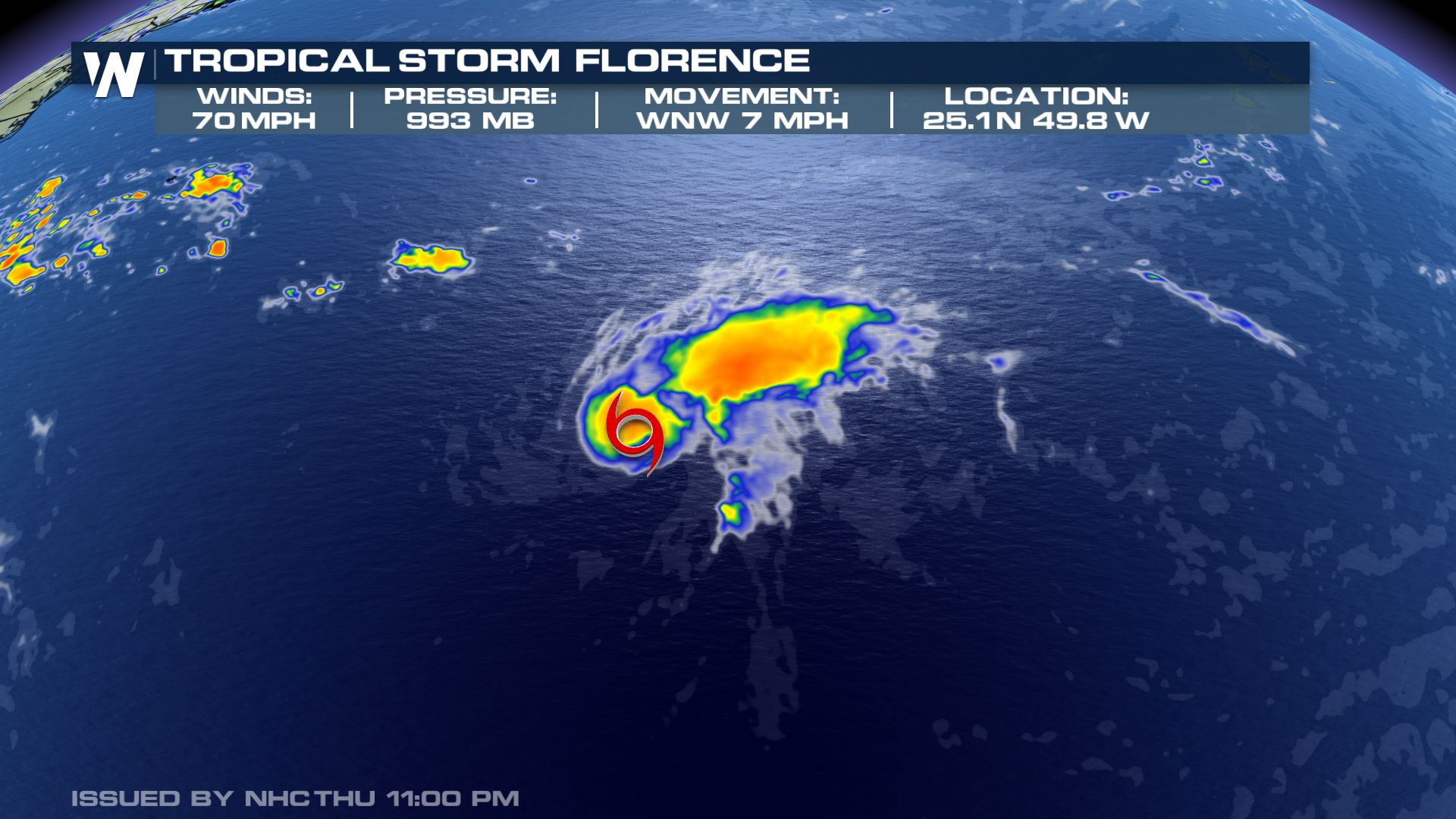 Florence storm statistics as of 11 p.m. eastern Thursday
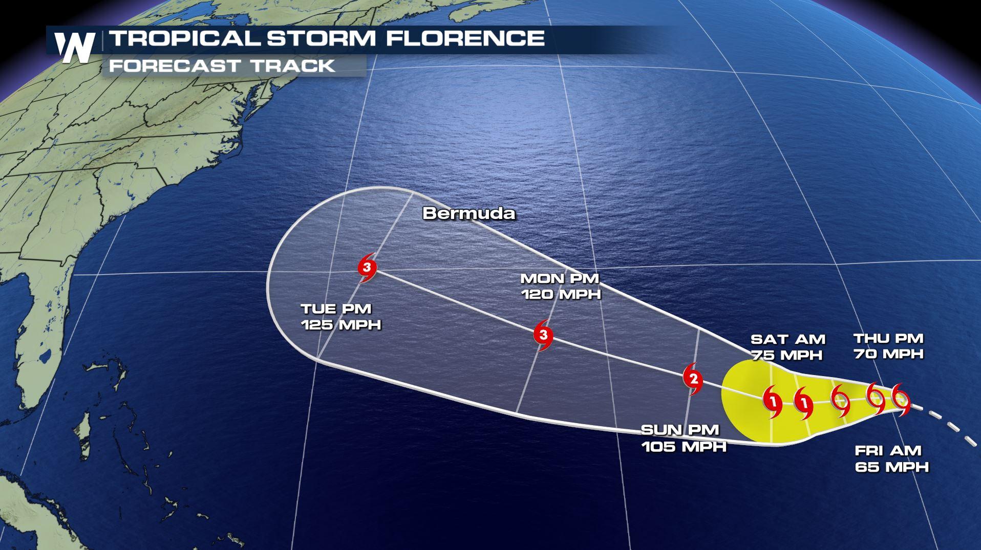
Now the bad news. The forecast has the track of the storm coming very close to Bermuda by Tuesday. And the storm is expected to once again strengthen into a major hurricane by Monday, with winds between 105 mph and 125 mph. You can see the track of the storm in the illustration below. Florence may continue to weaken early Friday. But as the system moves westward, it will encounter less wind shear. This will allow the storm to intensify rapidly. The Cone of Uncertainty also includes Bermuda. So the island could see a direct impact if the track shifts to the north over the next several days.
Florence storm statistics as of 11 p.m. eastern Thursday
Now the bad news. The forecast has the track of the storm coming very close to Bermuda by Tuesday. And the storm is expected to once again strengthen into a major hurricane by Monday, with winds between 105 mph and 125 mph. You can see the track of the storm in the illustration below. Florence may continue to weaken early Friday. But as the system moves westward, it will encounter less wind shear. This will allow the storm to intensify rapidly. The Cone of Uncertainty also includes Bermuda. So the island could see a direct impact if the track shifts to the north over the next several days.
 The forecast for Florence through Tuesday, September 11
The illustration below showcases various hurricane models in one view. Each line represents a different model. Several of these models have the storm very close to the east coast of the U.S. by Wednesday of next week. But there is uncertainly regarding the path the storm.
The forecast for Florence through Tuesday, September 11
The illustration below showcases various hurricane models in one view. Each line represents a different model. Several of these models have the storm very close to the east coast of the U.S. by Wednesday of next week. But there is uncertainly regarding the path the storm.
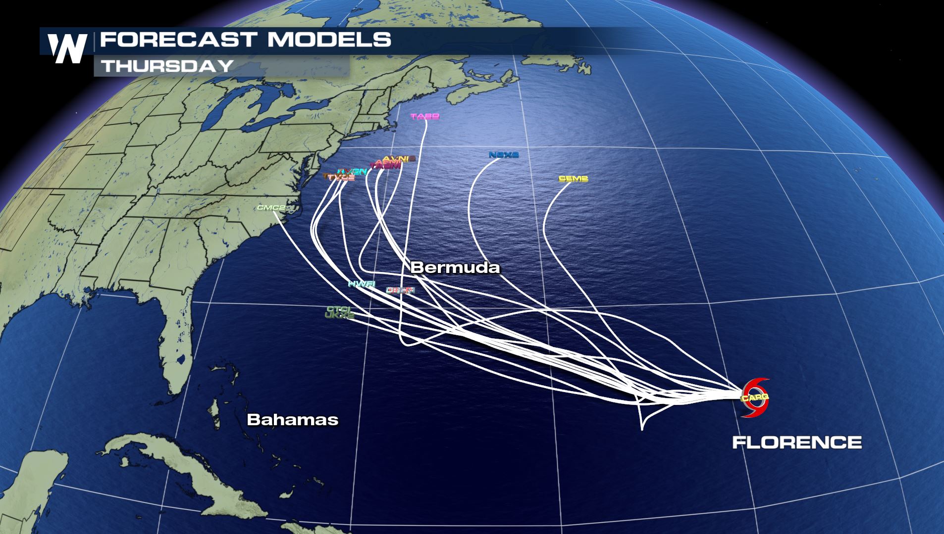 The forecast models for the *center* of Florence now through Thursday, September 13
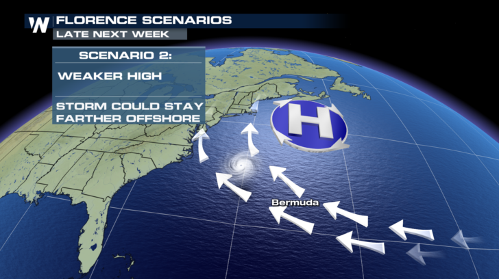
A large area of high pressure is forecasted be north of the storm. If the high pressure is very strong, Florence will not be able to turn northward as easily, and may take a more direct path toward the eastern seaboard. In this case, North Carolina and Virginia are more likely to be impacted by the storm.
The forecast models for the *center* of Florence now through Thursday, September 13
A large area of high pressure is forecasted be north of the storm. If the high pressure is very strong, Florence will not be able to turn northward as easily, and may take a more direct path toward the eastern seaboard. In this case, North Carolina and Virginia are more likely to be impacted by the storm.
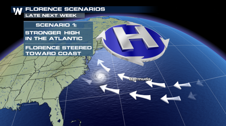 However, if the high pressure area is weaker, the storm may be able to curve to the north. The northeastern U.S. would be more likely to see direct impacts from the storm in this scenario.
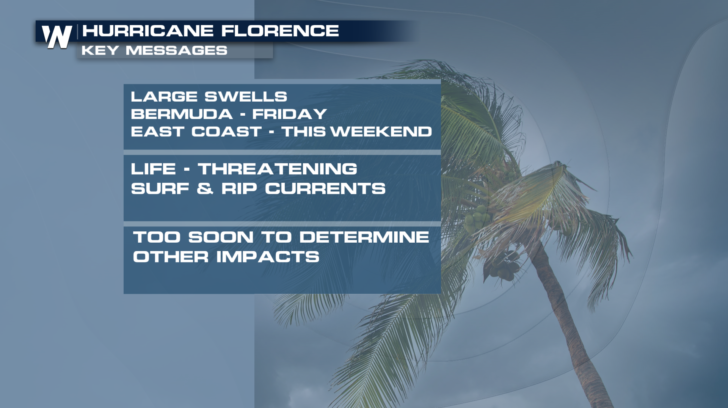
 At the moment, it's too early to determine with a great deal of certainly exactly where the storm is going. It's still a long way off in time and distance. However, Bermuda can expect large swells beginning on Friday. And portions of the east coast will see these large swells over the weekend. If you plan on swimming in the Atlantic, please beware of large surf and rip currents. Florence will still be far away, but the impacts from the storm will begin.
 As always, stay tuned to WeatherNation for more updates on Hurricane Florence, and the rest of the tropics. September is typically the most active month in the tropical season. And more storms are almost certain to form.
For WeatherNation: Meteorologist Matt Monroe with contribution from Meteorologist Steve Glazier
As always, stay tuned to WeatherNation for more updates on Hurricane Florence, and the rest of the tropics. September is typically the most active month in the tropical season. And more storms are almost certain to form.
For WeatherNation: Meteorologist Matt Monroe with contribution from Meteorologist Steve Glazier
Florence storm statistics as of 11 p.m. eastern Thursday
Now the bad news. The forecast has the track of the storm coming very close to Bermuda by Tuesday. And the storm is expected to once again strengthen into a major hurricane by Monday, with winds between 105 mph and 125 mph. You can see the track of the storm in the illustration below. Florence may continue to weaken early Friday. But as the system moves westward, it will encounter less wind shear. This will allow the storm to intensify rapidly. The Cone of Uncertainty also includes Bermuda. So the island could see a direct impact if the track shifts to the north over the next several days.
The forecast for Florence through Tuesday, September 11
The illustration below showcases various hurricane models in one view. Each line represents a different model. Several of these models have the storm very close to the east coast of the U.S. by Wednesday of next week. But there is uncertainly regarding the path the storm.
The forecast models for the *center* of Florence now through Thursday, September 13
A large area of high pressure is forecasted be north of the storm. If the high pressure is very strong, Florence will not be able to turn northward as easily, and may take a more direct path toward the eastern seaboard. In this case, North Carolina and Virginia are more likely to be impacted by the storm.
However, if the high pressure area is weaker, the storm may be able to curve to the north. The northeastern U.S. would be more likely to see direct impacts from the storm in this scenario.
At the moment, it's too early to determine with a great deal of certainly exactly where the storm is going. It's still a long way off in time and distance. However, Bermuda can expect large swells beginning on Friday. And portions of the east coast will see these large swells over the weekend. If you plan on swimming in the Atlantic, please beware of large surf and rip currents. Florence will still be far away, but the impacts from the storm will begin.
As always, stay tuned to WeatherNation for more updates on Hurricane Florence, and the rest of the tropics. September is typically the most active month in the tropical season. And more storms are almost certain to form.
For WeatherNation: Meteorologist Matt Monroe with contribution from Meteorologist Steve GlazierAll Weather News
More
Wildfire Outbreak in the Pacific Northwest
Conditions have been incredibly dry out west.
2 Aug 2026 1:30 PM

After Reaching Category 5, Genevieve Weakens in the Pacific
PacificGenevieve formed on last Friday south
2 Aug 2026 1:25 PM

More Storms for the East Sunday and Monday
A low-pressure system crashing through the Mi
2 Aug 2026 1:25 PM


Flooding, Severe Storms Target the Midwest Again
After an active week of storms across the nor
1 Aug 2026 1:40 AM

Flooding Risk Increases as Heavy Rain Targets the Tri-State Area
Tuesday, heavy rainfall moved across the Nort
30 Jul 2026 12:25 AM

Severe Weather: Energy From the Midwest Now in the Southeast
UPPER MIDWEST - Through Monday, dangerous tor
29 Jul 2026 10:30 PM