Thunderstorm Study in Argentina Aims to Improve Severe Storm Forecasts
Special Stories
26 Oct 2018 9:41 AM
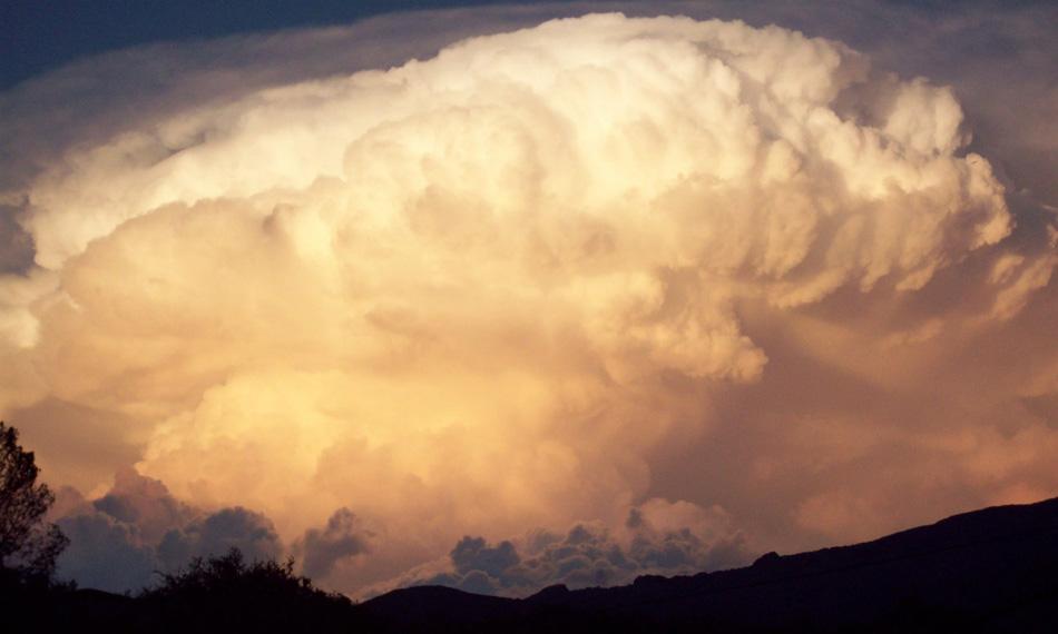
[Researchers with RELAMPAGO-CACTI will track severe thunderstorms in South America's Pampas. Image from RELAMPAGO-CACTI]
[UCAR-NCAR] It's spring in the Pampas — the time of year when vast, intense thunderstorms roil across the region, which extends from the foothills of the Andes Mountains in Argentina to the coasts of Brazil and Uruguay.
Next month, more than 150 scientists, including staff from the National Center for Atmospheric Research (NCAR), will head to Argentina as part of a field campaign to discover why these thunderstorms may be the most intense on Earth. The research project, funded by the National Science Foundation (NSF), aims to improve the prediction of severe storms.
Like the springtime storms that form on the U.S. Great Plains, the storms in the Pampas bring a variety of severe weather, including hail, damaging winds, torrential rains, and deadly tornadoes with catastrophic impacts. But the thunderstorms in the Southern Hemisphere are larger, have more lightning, and may produce more frequent large hail and flooding than their Northern Hemisphere counterparts.
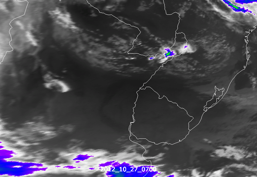 [Met-9 IR10.8 image from October 27, 2012 of intense thunderstorms in Argentina. From eumetsat]
Residents of the Pampas region know about the dangers of these storms, but the tempests are often difficult to predict.
"The frequency and intensity of rainfall in South America make the region an ideal natural laboratory to increase our understanding of heavy rain-producing storms around the globe," said Chungu Lu, a program director in NSF's Division of Atmospheric and Geospace Sciences, which funded the project.
[Met-9 IR10.8 image from October 27, 2012 of intense thunderstorms in Argentina. From eumetsat]
Residents of the Pampas region know about the dangers of these storms, but the tempests are often difficult to predict.
"The frequency and intensity of rainfall in South America make the region an ideal natural laboratory to increase our understanding of heavy rain-producing storms around the globe," said Chungu Lu, a program director in NSF's Division of Atmospheric and Geospace Sciences, which funded the project.
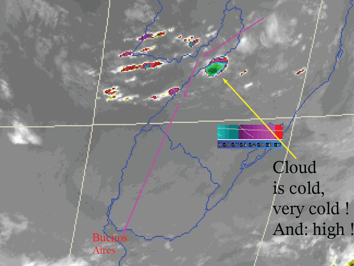 [GOES-13, October 27, 2012, 08:15 UTC, IR channel from Argentina. From eumetsat]
According to atmospheric scientist Steve Nesbitt of the of the University of Illinois, lead principal investigator for RELAMPAGO, the region's topography is unique, with Pampas grasslands and mountains in close proximity. The terrain provides the ideal set-up for the formation of severe storms that affect a wide region of South America.
"Argentina turns out to be a very special place," said Nesbitt. "Its storms are similar in some ways to those of the U.S. Great Plains, which also have severe thunderstorms, but the geography is different. That may exert important controls on how thunderstorms behave. Argentina's geography may set the stage for thunderstorms we think are the strongest on Earth."
Researchers will deploy an array of instrumentation, and track storms from formation through maturity.
Networks of fixed and mobile radars, including NSF's Dopplers on Wheels, will profile the storms' heavy rainfall, strong winds, and hail.
[GOES-13, October 27, 2012, 08:15 UTC, IR channel from Argentina. From eumetsat]
According to atmospheric scientist Steve Nesbitt of the of the University of Illinois, lead principal investigator for RELAMPAGO, the region's topography is unique, with Pampas grasslands and mountains in close proximity. The terrain provides the ideal set-up for the formation of severe storms that affect a wide region of South America.
"Argentina turns out to be a very special place," said Nesbitt. "Its storms are similar in some ways to those of the U.S. Great Plains, which also have severe thunderstorms, but the geography is different. That may exert important controls on how thunderstorms behave. Argentina's geography may set the stage for thunderstorms we think are the strongest on Earth."
Researchers will deploy an array of instrumentation, and track storms from formation through maturity.
Networks of fixed and mobile radars, including NSF's Dopplers on Wheels, will profile the storms' heavy rainfall, strong winds, and hail.
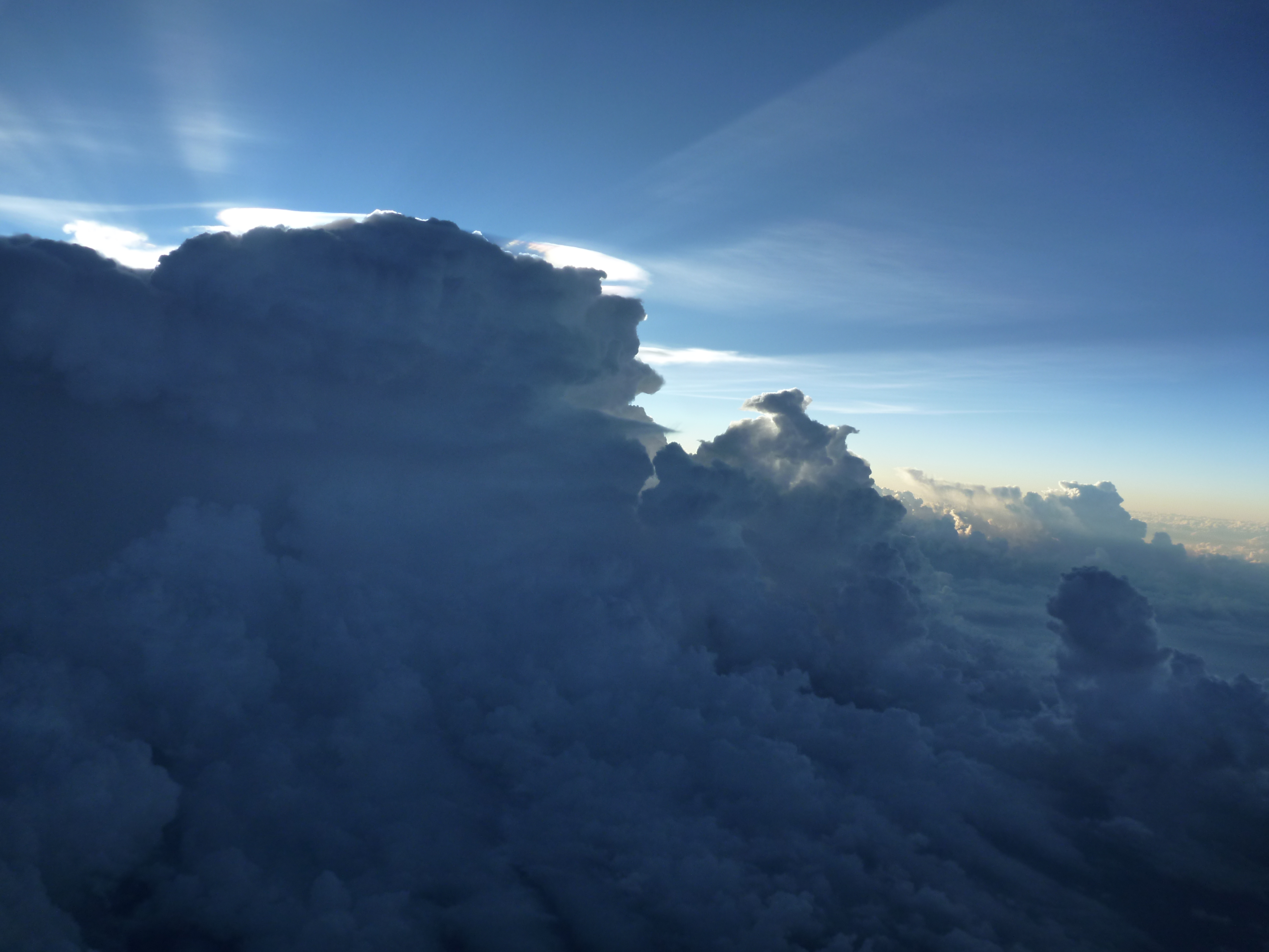 [Thunderstorm from Argentina. From eumetsat]
Environments around these severe storms, thought to be important in dictating how the storms develop, will be observed with weather balloon launches as frequently as every 30 minutes; mobile weather stations; and vehicles with instruments that capture small-scale weather patterns.
Research aircraft will observe conditions aloft in the storms' very early stages. Continuous lightning-observing instruments will improve the understanding of why Argentina's storms produce extreme lightning.
As intense precipitation falls, a flood-chasing team will measure streamflow in rivers. Drones and local citizens' mobile phone apps will help monitor hail.
NCAR's Earth Observing Laboratory is contributing two kinds of instrumentation to the effort. The first is the Water Vapor Differential Absorption Lidar (WV-DIAL), an innovative instrument developed at NCAR that measures water vapor profiles in the lower atmosphere at high temporal and vertical resolution.
[Thunderstorm from Argentina. From eumetsat]
Environments around these severe storms, thought to be important in dictating how the storms develop, will be observed with weather balloon launches as frequently as every 30 minutes; mobile weather stations; and vehicles with instruments that capture small-scale weather patterns.
Research aircraft will observe conditions aloft in the storms' very early stages. Continuous lightning-observing instruments will improve the understanding of why Argentina's storms produce extreme lightning.
As intense precipitation falls, a flood-chasing team will measure streamflow in rivers. Drones and local citizens' mobile phone apps will help monitor hail.
NCAR's Earth Observing Laboratory is contributing two kinds of instrumentation to the effort. The first is the Water Vapor Differential Absorption Lidar (WV-DIAL), an innovative instrument developed at NCAR that measures water vapor profiles in the lower atmosphere at high temporal and vertical resolution.
 [Aircraft weather radar image of thunderstorms in Argentina on 27 October 2012, around 08:06 UTC. From eumetsat]
NCAR is also deploying a network of weather stations, called the Integrated Surface Flux System, which will be set up along rivers in the area. The goal is to measure heavy rain and then observe how flooding occurs across the region.
"RELAMPAGO instruments will probe these regions with remote sensing to improve computer models of what's going on inside the storms," Nesbitt said.
The project is also funded by the U.S. Department of Energy, National Oceanic and Atmospheric Administration, National Aeronautics and Space Administration, and South American federal and provincial agencies. Please visit RELAMPAGO-CACTI for more information.
Edited for WeatherNation by Meteorologist Mace Michaels
[Aircraft weather radar image of thunderstorms in Argentina on 27 October 2012, around 08:06 UTC. From eumetsat]
NCAR is also deploying a network of weather stations, called the Integrated Surface Flux System, which will be set up along rivers in the area. The goal is to measure heavy rain and then observe how flooding occurs across the region.
"RELAMPAGO instruments will probe these regions with remote sensing to improve computer models of what's going on inside the storms," Nesbitt said.
The project is also funded by the U.S. Department of Energy, National Oceanic and Atmospheric Administration, National Aeronautics and Space Administration, and South American federal and provincial agencies. Please visit RELAMPAGO-CACTI for more information.
Edited for WeatherNation by Meteorologist Mace Michaels
[Met-9 IR10.8 image from October 27, 2012 of intense thunderstorms in Argentina. From eumetsat]
Residents of the Pampas region know about the dangers of these storms, but the tempests are often difficult to predict.
"The frequency and intensity of rainfall in South America make the region an ideal natural laboratory to increase our understanding of heavy rain-producing storms around the globe," said Chungu Lu, a program director in NSF's Division of Atmospheric and Geospace Sciences, which funded the project.
CHASING STORMS AND FLOODS IN ARGENTINA
The projects designed to observe these deadly storms are collectively called RELAMPAGO (Remote sensing of Electrification, Lightning And Mesoscale/microscale Processes with Adaptive Ground Observations) and CACTI (Clouds, Aerosols and Complex Terrain Interactions). The projects constitute the largest land-based atmospheric sciences field campaign ever conducted outside the U.S.
[GOES-13, October 27, 2012, 08:15 UTC, IR channel from Argentina. From eumetsat]
According to atmospheric scientist Steve Nesbitt of the of the University of Illinois, lead principal investigator for RELAMPAGO, the region's topography is unique, with Pampas grasslands and mountains in close proximity. The terrain provides the ideal set-up for the formation of severe storms that affect a wide region of South America.
"Argentina turns out to be a very special place," said Nesbitt. "Its storms are similar in some ways to those of the U.S. Great Plains, which also have severe thunderstorms, but the geography is different. That may exert important controls on how thunderstorms behave. Argentina's geography may set the stage for thunderstorms we think are the strongest on Earth."
Researchers will deploy an array of instrumentation, and track storms from formation through maturity.
Networks of fixed and mobile radars, including NSF's Dopplers on Wheels, will profile the storms' heavy rainfall, strong winds, and hail.
[Thunderstorm from Argentina. From eumetsat]
Environments around these severe storms, thought to be important in dictating how the storms develop, will be observed with weather balloon launches as frequently as every 30 minutes; mobile weather stations; and vehicles with instruments that capture small-scale weather patterns.
Research aircraft will observe conditions aloft in the storms' very early stages. Continuous lightning-observing instruments will improve the understanding of why Argentina's storms produce extreme lightning.
As intense precipitation falls, a flood-chasing team will measure streamflow in rivers. Drones and local citizens' mobile phone apps will help monitor hail.
NCAR's Earth Observing Laboratory is contributing two kinds of instrumentation to the effort. The first is the Water Vapor Differential Absorption Lidar (WV-DIAL), an innovative instrument developed at NCAR that measures water vapor profiles in the lower atmosphere at high temporal and vertical resolution.
[Aircraft weather radar image of thunderstorms in Argentina on 27 October 2012, around 08:06 UTC. From eumetsat]
NCAR is also deploying a network of weather stations, called the Integrated Surface Flux System, which will be set up along rivers in the area. The goal is to measure heavy rain and then observe how flooding occurs across the region.
"RELAMPAGO instruments will probe these regions with remote sensing to improve computer models of what's going on inside the storms," Nesbitt said.
The project is also funded by the U.S. Department of Energy, National Oceanic and Atmospheric Administration, National Aeronautics and Space Administration, and South American federal and provincial agencies. Please visit RELAMPAGO-CACTI for more information.
Edited for WeatherNation by Meteorologist Mace MichaelsAll Weather News
More
East Gears Up for Stormy, Wet Weekend
A low pressure system crashing through the Mi
1 Aug 2026 9:15 PM


Flooding, Severe Storms Target the Midwest Again
After an active week of storms across the nor
1 Aug 2026 1:40 AM

After Reaching Category 5, Genevieve Weakens in the Pacific
PacificFausto is now a post-tropical cyclone.
31 Jul 2026 1:30 AM

Flooding Risk Increases as Heavy Rain Targets the Tri-State Area
Tuesday, heavy rainfall moved across the Nort
30 Jul 2026 12:25 AM

Severe Weather: Energy From the Midwest Now in the Southeast
UPPER MIDWEST - Through Monday, dangerous tor
29 Jul 2026 10:30 PM