Tornadoes Strike Northeast Ohio Tuesday Night
Top Stories
8 Apr 2020 3:30 PM
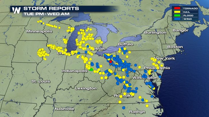
Severe thunderstorms developed across the Great Lakes and Mid-Atlantic regions on Tuesday, April 7, 2020. These storms brought incredibly large hail and damaging wind to multiple states. Unfortunately, these storms also spawned at least three tornadoes in Ohio.
 Well after dark on Tuesday night, a powerful line of severe thunderstorms moved southeast off of Lake Erie into northern Ohio.
https://twitter.com/Jeremy_OHWX/status/1247718846372491267
As the line of storms continued to move inland, rotation began to occur in some rural and suburban areas southwest of Cleveland just after 11 pm ET. A Tornado Warning was issued by the National Weather Service's Cleveland weather forecast office.
https://twitter.com/KellyDWeather/status/1247746957344292866
https://twitter.com/MedinaWxCast/status/1247751408515829761
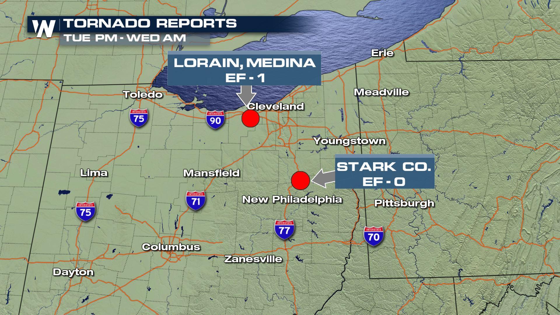
Around 11:30 pm ET, a dangerous nighttime tornado touched down near the village of Grafton in Lorain County. This tornado stayed on the ground for approximately ten minutes, covering 11.5 miles moving in a southeast direction. The tornado eventually lifted south of the city of Medina in Medina County at 11:40 pm ET.
Well after dark on Tuesday night, a powerful line of severe thunderstorms moved southeast off of Lake Erie into northern Ohio.
https://twitter.com/Jeremy_OHWX/status/1247718846372491267
As the line of storms continued to move inland, rotation began to occur in some rural and suburban areas southwest of Cleveland just after 11 pm ET. A Tornado Warning was issued by the National Weather Service's Cleveland weather forecast office.
https://twitter.com/KellyDWeather/status/1247746957344292866
https://twitter.com/MedinaWxCast/status/1247751408515829761
Around 11:30 pm ET, a dangerous nighttime tornado touched down near the village of Grafton in Lorain County. This tornado stayed on the ground for approximately ten minutes, covering 11.5 miles moving in a southeast direction. The tornado eventually lifted south of the city of Medina in Medina County at 11:40 pm ET.
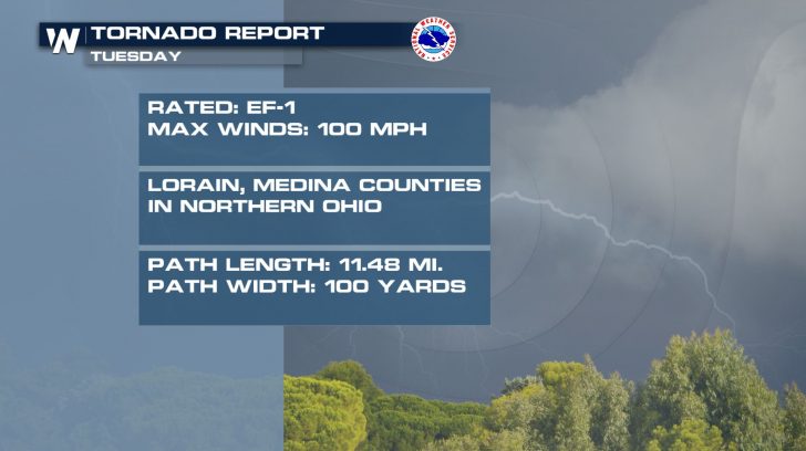 Tornado damage peaked at EF-1 intensity with maximum wind speeds of 100 miles per hour. Numerous large trees toppled onto homes and buildings, causing extensive damage in some cases.
https://twitter.com/bruce_bishop/status/1247912967326310406
https://twitter.com/MedinaWxCast/status/1247857519667621889
https://twitter.com/MedinaWxCast/status/1247851691782942721
https://twitter.com/MedinaWxCast/status/1247851928010272774
https://twitter.com/MedinaWxCast/status/1247854590520971264
As the line of severe thunderstorms continued southeast from there, an EF-1 tornado touched down just before midnight in Summit County. From the city of Barberton to the city of Green, this tornado impacted suburban areas of Akron.
https://twitter.com/NWSCLE/status/1248050014284156928
Preliminary information from the National Weather Service indicate that this tornado was on the ground for approximately 10 miles and had winds up to 90 miles per hour.
https://twitter.com/emilyhamiltontv/status/1247930252661309440
https://twitter.com/NicolKory/status/1247983143979810822
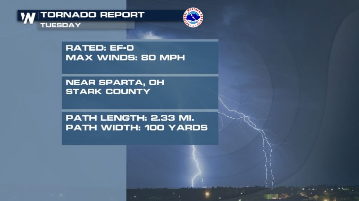
Further south in Stark County, another tornado touched down around 12:22 am ET. Tornado sirens were blaring throughout the county, including the city of Canton.
https://twitter.com/bryanweather/status/1247737630088990720
This tornado was rated an EF-0, with maximum wind speeds of 80 miles per hour. It was on the ground for just over 2 miles near the small village of East Sparta.
Tornado damage peaked at EF-1 intensity with maximum wind speeds of 100 miles per hour. Numerous large trees toppled onto homes and buildings, causing extensive damage in some cases.
https://twitter.com/bruce_bishop/status/1247912967326310406
https://twitter.com/MedinaWxCast/status/1247857519667621889
https://twitter.com/MedinaWxCast/status/1247851691782942721
https://twitter.com/MedinaWxCast/status/1247851928010272774
https://twitter.com/MedinaWxCast/status/1247854590520971264
As the line of severe thunderstorms continued southeast from there, an EF-1 tornado touched down just before midnight in Summit County. From the city of Barberton to the city of Green, this tornado impacted suburban areas of Akron.
https://twitter.com/NWSCLE/status/1248050014284156928
Preliminary information from the National Weather Service indicate that this tornado was on the ground for approximately 10 miles and had winds up to 90 miles per hour.
https://twitter.com/emilyhamiltontv/status/1247930252661309440
https://twitter.com/NicolKory/status/1247983143979810822
Further south in Stark County, another tornado touched down around 12:22 am ET. Tornado sirens were blaring throughout the county, including the city of Canton.
https://twitter.com/bryanweather/status/1247737630088990720
This tornado was rated an EF-0, with maximum wind speeds of 80 miles per hour. It was on the ground for just over 2 miles near the small village of East Sparta.
 Springtime is an especially volatile season for severe weather and tornadoes across the United States. In fact, the threat of severe weather is in the forecast all the way through Sunday! Keep it tuned to WeatherNation as we track storms from the Midwest to the South.
For WeatherNation, I'm Meteorologist Joe Astolfi.
Springtime is an especially volatile season for severe weather and tornadoes across the United States. In fact, the threat of severe weather is in the forecast all the way through Sunday! Keep it tuned to WeatherNation as we track storms from the Midwest to the South.
For WeatherNation, I'm Meteorologist Joe Astolfi.
Well after dark on Tuesday night, a powerful line of severe thunderstorms moved southeast off of Lake Erie into northern Ohio.
https://twitter.com/Jeremy_OHWX/status/1247718846372491267
As the line of storms continued to move inland, rotation began to occur in some rural and suburban areas southwest of Cleveland just after 11 pm ET. A Tornado Warning was issued by the National Weather Service's Cleveland weather forecast office.
https://twitter.com/KellyDWeather/status/1247746957344292866
https://twitter.com/MedinaWxCast/status/1247751408515829761
Around 11:30 pm ET, a dangerous nighttime tornado touched down near the village of Grafton in Lorain County. This tornado stayed on the ground for approximately ten minutes, covering 11.5 miles moving in a southeast direction. The tornado eventually lifted south of the city of Medina in Medina County at 11:40 pm ET.
Tornado damage peaked at EF-1 intensity with maximum wind speeds of 100 miles per hour. Numerous large trees toppled onto homes and buildings, causing extensive damage in some cases.
https://twitter.com/bruce_bishop/status/1247912967326310406
https://twitter.com/MedinaWxCast/status/1247857519667621889
https://twitter.com/MedinaWxCast/status/1247851691782942721
https://twitter.com/MedinaWxCast/status/1247851928010272774
https://twitter.com/MedinaWxCast/status/1247854590520971264
As the line of severe thunderstorms continued southeast from there, an EF-1 tornado touched down just before midnight in Summit County. From the city of Barberton to the city of Green, this tornado impacted suburban areas of Akron.
https://twitter.com/NWSCLE/status/1248050014284156928
Preliminary information from the National Weather Service indicate that this tornado was on the ground for approximately 10 miles and had winds up to 90 miles per hour.
https://twitter.com/emilyhamiltontv/status/1247930252661309440
https://twitter.com/NicolKory/status/1247983143979810822
Further south in Stark County, another tornado touched down around 12:22 am ET. Tornado sirens were blaring throughout the county, including the city of Canton.
https://twitter.com/bryanweather/status/1247737630088990720
This tornado was rated an EF-0, with maximum wind speeds of 80 miles per hour. It was on the ground for just over 2 miles near the small village of East Sparta.
Springtime is an especially volatile season for severe weather and tornadoes across the United States. In fact, the threat of severe weather is in the forecast all the way through Sunday! Keep it tuned to WeatherNation as we track storms from the Midwest to the South.
For WeatherNation, I'm Meteorologist Joe Astolfi.All Weather News
More


More Storms for the East Sunday and Monday
A low-pressure system crashing through the Mi
2 Aug 2026 2:20 AM

After Reaching Category 5, Genevieve Weakens in the Pacific
PacificGenevieve formed on last Friday south
2 Aug 2026 1:30 AM

Flooding, Severe Storms Target the Midwest Again
After an active week of storms across the nor
1 Aug 2026 1:40 AM

Flooding Risk Increases as Heavy Rain Targets the Tri-State Area
Tuesday, heavy rainfall moved across the Nort
30 Jul 2026 12:25 AM

Severe Weather: Energy From the Midwest Now in the Southeast
UPPER MIDWEST - Through Monday, dangerous tor
29 Jul 2026 10:30 PM