Updated August Outlook: Wet & Warm East, Hot & Dry West
Special Stories
5 Aug 2020 1:00 AM
[From NOAA written by Tom Di Liberto] We’ve entered the dog days of summer across the United States which, along with continued summer heat, comes a climatological increase in hurricane activity in the Tropical Atlantic Ocean. (The season’s average peaks occurs around September 10). The updated August 2020 outlook favors hotter-than-average temperatures along both coasts, while tropical moisture is likely to lead to a wetter-than-average August along the East Coast. Plenty of reasons to try to stay inside to beat the heat and rain, if you ask me. Read on to find out more about the August 2020 outlook for temperature and precipitation from NOAA’s Climate Prediction Center.
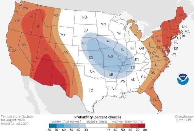
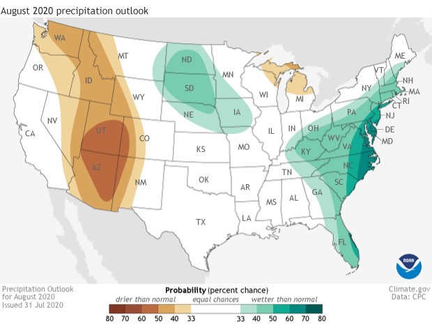
The monthly outlooks from the Climate Prediction Center, importantly, are not predictions for the actual temperatures or precipitation amounts on a given day in August. They simply provide the probability (percent chance) that August precipitation or temperature at any location will be in the upper, middle or lower third of the climatological record (1981-2020) for August. The upper and lower third correspond to “well above” and “well below” average or, similarly, “much wetter” or “much cooler” than average. The colors (red or blue for temperature; brown or teal for precipitation) indicate which outcome is most likely. Darker colors mean higher chances of a given outcome; not more extreme conditions.
https://twitter.com/NWSCPC/status/1289280569012973568
TEMPERATURE OUTLOOK: COOLER THAN AVERAGE OUTLOOK SANDWICHED BETWEEN HOTTER THAN AVERAGE
Unlike previous months’ outlooks, August’s temperature outlook does not favor a nearly coast-to-coast swath of hotter-than-average temperatures. Instead, the tilt in the odds towards a hotter-than-average August are located over both the western and eastern United States, with the highest probabilities (60-70%) located across the desert Southwest in Arizona and New Mexico. But stuck in between, a broad area across the central United States from Nebraska to the Mississippi River is forecast to favor a cooler-than-average month. This region of the country experienced a wetter-than-average July. This wetness is one of the reasons why scientists expect temperatures to be below average.
PRECIPITATION OUTLOOK: WET EAST COAST AND A DRY SOUTHWEST
The precipitation outlook is a tale of two halves of the country. Across the Mountain West and into the Southwest, a drier-than-average August is favored with the highest probabilities over Arizona and Utah. Just like last month’s outlook, this drier- and hotter-than-average outlook for the Southwest indicates a sluggish or weaker-than-average monsoon, which usually begins bringing rain to the southwestern United States in July and August. Meanwhile, the outlook has a tilt in the odds towards a wetter-than-average August for the entire East Coast, with a 60-70% chance across the Mid-Atlantic States. The reason? Look to the tropics! The precipitation outlook across the eastern United States is heavily influenced by the rain expected from Hurricane, now Tropical Storm, Isaias. As the storm moves up the East Coast during the first week of August, tremendous amounts of rain are forecast. For locations where the odds for a wetter-than-average month are greater than 50%, the forecast rain from just this storm would make it impossible for monthly precipitation totals to be below normal. That’s right! If the forecast rains from Isaias come to fruition, some areas need not receive one more drop of rain for the entire month to have August totals be around average. https://twitter.com/NWSCPC/status/1289280959523598336 This event highlights the impact one or two major events can have on monthly outlooks for precipitation, and how monitoring the evolution of precipitation during the month is important. For instance, if the rains stop for the rest of the month after Isaias passes through, there will likely be dryness concerns come September, even if August rainfall amounts were near average or even above average. To see the entire discussion of the monthly climate outlooks from the Climate Prediction Center, head to their website. Later this month, we'll have a recap with the climate highlights on what happened during July in the United States. Edited for WeatherNation by Mace MichaelsAll Weather News
More
Strong July Cold Front Sparks Severe Weather
A strong July cold front is racing through th
15 Jul 2025 7:15 PM

Monitoring "Invest 93L" Near Florida
The National Hurricane Center has upgraded th
15 Jul 2025 7:05 PM

Flash Flooding Threat Continues in Texas
It has been 10 days since the devastating flo
15 Jul 2025 6:10 PM

Torrential Rain Swamps the Northeast Monday
A cold front pushing through the Eastern Seab
15 Jul 2025 6:05 PM

Dangerous Heat Impacting the Western U.S.
High pressure is moving off the California co
15 Jul 2025 10:30 AM

Heavy Rain, Flooding Threat Returns to Florida
Keep the rain boots handy in Florida - heavy
13 Jul 2025 12:50 PM

Severe Storm Risk Pushes into the Great Lakes, Ohio Valley
Friday was another busy day with severe weath
12 Jul 2025 8:00 PM