Updated January Outlook from NOAA's Climate Prediction Center
Special Stories
5 Jan 2022 1:00 AM
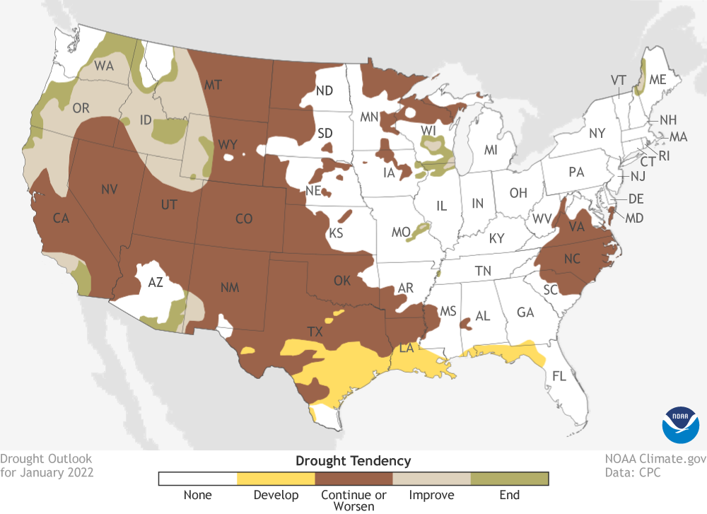
[From NOAA Climate by Rebecca Lindsey] The calendar has rolled over to the new year and the second month of meteorological winter, and the NOAA Climate Prediction Center has released its outlooks for January 2022 temperature, precipitation, and drought. The dominant pattern for the Lower 48 states is a north-south split in the most likely temperature and precipitation outcomes: cooler- and wetter-than-average conditions across much of the North and warmer and drier conditions across the South. While drought is likely to continue or worsen across much of the West in January, significant improvement is likely across the Pacific Northwest.
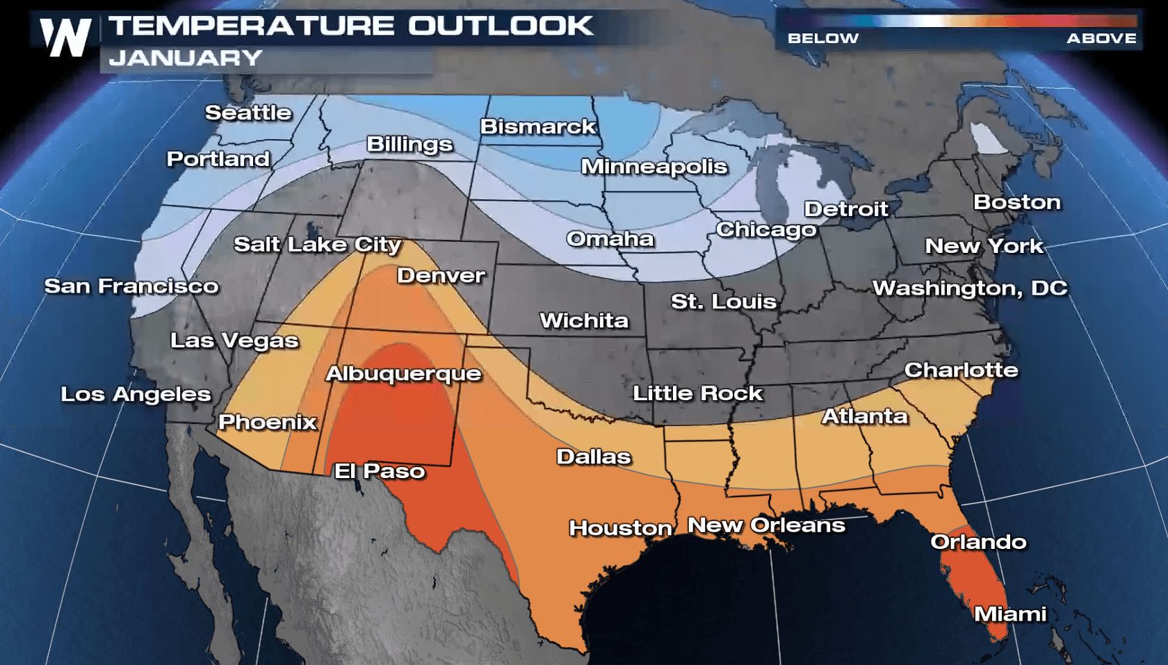
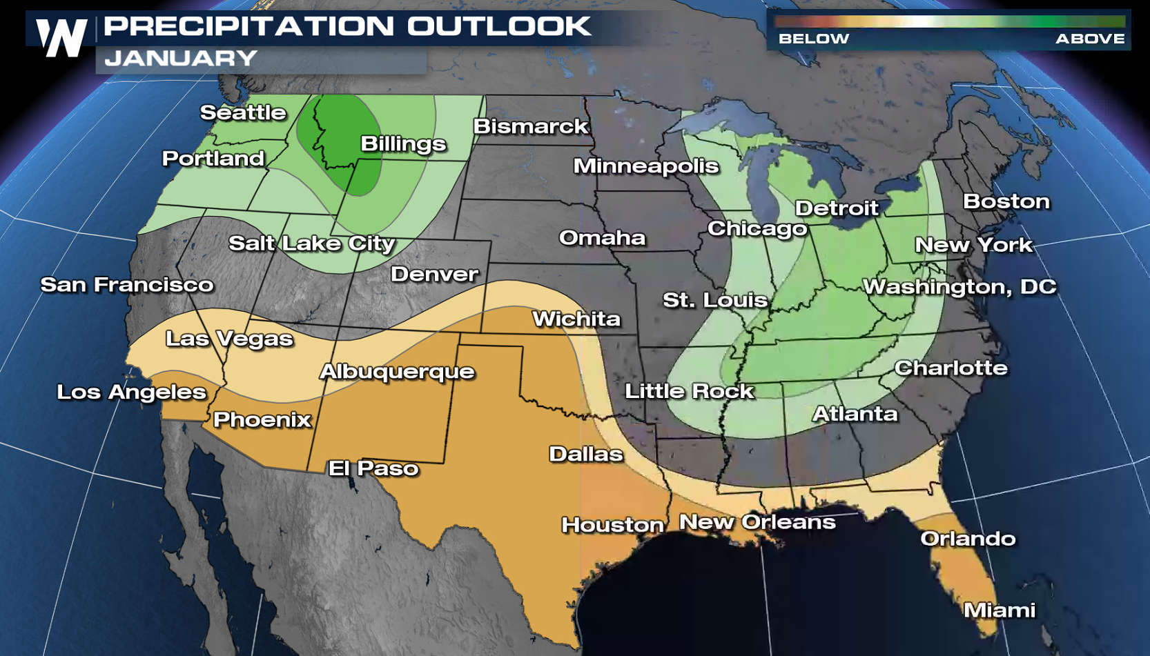 Cooler-than-average temperatures are favored across the Northern contiguous United States from the West Coast to the central Great Lakes, while warmer-than-average temperatures are favored across the Southwest and Gulf Coast states. A wetter-than-average January is favored in the Pacific Northwest and from the Great Lakes down into the Ohio River Valley. A drier-than-average January is favored across the South. In the Pacific Northwest, the cool-wet combination is likely to improve or even end the drought across parts of Washington, Oregon, northern California, Idaho, western Montana and Wyoming, and northern Utah.
 The Madden-Julian Oscillation, or “MJO” for short, is couplet of weather patterns—a large area of storminess adjacent to a large area of clear, calm weather—that traipses around the tropics every 2-3 months. Think of it like a traveling circus, or a Grateful Dead tour. Whenever the MJO arrives in a particular leg of its round-the-world tour, it tends to disrupt the downstream mid-latitude weather in predictable ways. In late December, the MJO was active in the Western Pacific, which tends to favor cooler-than-average temperatures across most of the contiguous U.S. That would work against the La Niña warming influence in the Southern United States, but strengthen it across parts of the North.
In addition, the Climate Prediction Center notes that the Pacific-North America pattern, which had been in its negative mode through December, is predicted to flip into its positive mode at least through the first half of January, according to climate models. The pressure and jet stream patterns associated with the positive PNA mode tend to oppose the typical climate impacts of La Niña, especially the temperature impacts. The positive PNA mode is associated with cooler-than-average temperatures across much of the South and East, in contrast to La Niña’s warming influence.
These overlapping influences—competing in some cases and reinforcing in others—are among the many factors that forecasters considered when building the January outlook. For more detail, read the full discussion.
Edited for WeatherNation by Mace Michaels
The Madden-Julian Oscillation, or “MJO” for short, is couplet of weather patterns—a large area of storminess adjacent to a large area of clear, calm weather—that traipses around the tropics every 2-3 months. Think of it like a traveling circus, or a Grateful Dead tour. Whenever the MJO arrives in a particular leg of its round-the-world tour, it tends to disrupt the downstream mid-latitude weather in predictable ways. In late December, the MJO was active in the Western Pacific, which tends to favor cooler-than-average temperatures across most of the contiguous U.S. That would work against the La Niña warming influence in the Southern United States, but strengthen it across parts of the North.
In addition, the Climate Prediction Center notes that the Pacific-North America pattern, which had been in its negative mode through December, is predicted to flip into its positive mode at least through the first half of January, according to climate models. The pressure and jet stream patterns associated with the positive PNA mode tend to oppose the typical climate impacts of La Niña, especially the temperature impacts. The positive PNA mode is associated with cooler-than-average temperatures across much of the South and East, in contrast to La Niña’s warming influence.
These overlapping influences—competing in some cases and reinforcing in others—are among the many factors that forecasters considered when building the January outlook. For more detail, read the full discussion.
Edited for WeatherNation by Mace Michaels
Cooler-than-average temperatures are favored across the Northern contiguous United States from the West Coast to the central Great Lakes, while warmer-than-average temperatures are favored across the Southwest and Gulf Coast states. A wetter-than-average January is favored in the Pacific Northwest and from the Great Lakes down into the Ohio River Valley. A drier-than-average January is favored across the South. In the Pacific Northwest, the cool-wet combination is likely to improve or even end the drought across parts of Washington, Oregon, northern California, Idaho, western Montana and Wyoming, and northern Utah.
Climate patterns at play
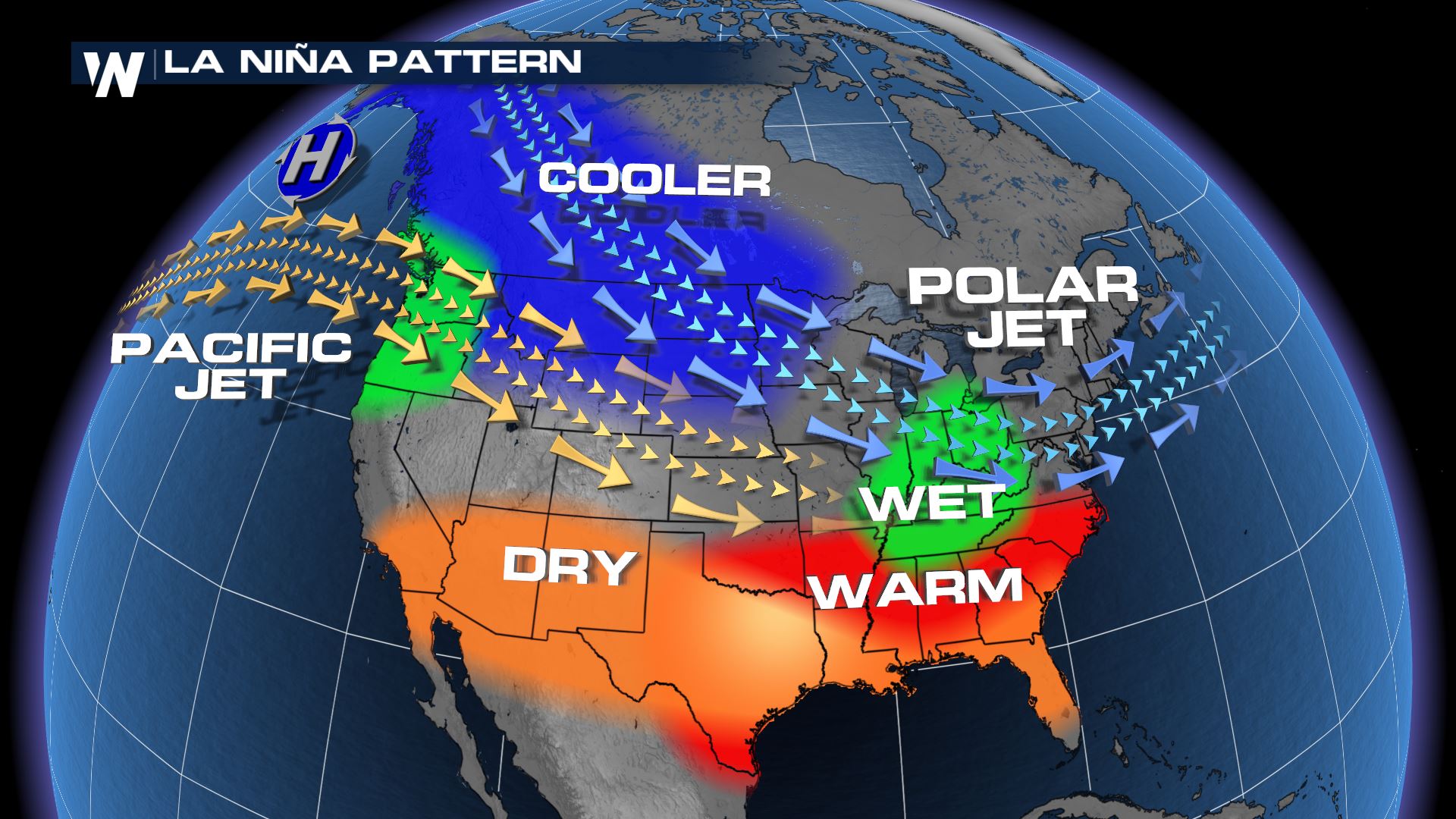
A large influence on the January temperature and climate outlooks is the ongoing La Niña event in the tropical Pacific. La Niña increases the chances for cool and wet winters across the northern tier of the country and warm and dry conditions across the south. That’s the big picture reflected on the maps. Given that fairly reliable connection between La Niña and U.S. winter weather patterns, you might be surprised that the probabilities for those typical climate outcomes aren’t stronger than they are. It’s important to remember that the ”typical impacts” of El Niño and La Niña are for the winter season (December-February) averages. On shorter time scales, other influences can come into play and weaken La Niña’s grip. Such is the case this month, when the phases of the Madden-Julian Oscillation and the Pacific-North America pattern are poised to undermine some of the typical La Niña impacts at least through the first part of the month, according to the discussion from NOAA Climate Prediction Center.
The Madden-Julian Oscillation, or “MJO” for short, is couplet of weather patterns—a large area of storminess adjacent to a large area of clear, calm weather—that traipses around the tropics every 2-3 months. Think of it like a traveling circus, or a Grateful Dead tour. Whenever the MJO arrives in a particular leg of its round-the-world tour, it tends to disrupt the downstream mid-latitude weather in predictable ways. In late December, the MJO was active in the Western Pacific, which tends to favor cooler-than-average temperatures across most of the contiguous U.S. That would work against the La Niña warming influence in the Southern United States, but strengthen it across parts of the North.
In addition, the Climate Prediction Center notes that the Pacific-North America pattern, which had been in its negative mode through December, is predicted to flip into its positive mode at least through the first half of January, according to climate models. The pressure and jet stream patterns associated with the positive PNA mode tend to oppose the typical climate impacts of La Niña, especially the temperature impacts. The positive PNA mode is associated with cooler-than-average temperatures across much of the South and East, in contrast to La Niña’s warming influence.
These overlapping influences—competing in some cases and reinforcing in others—are among the many factors that forecasters considered when building the January outlook. For more detail, read the full discussion.
Edited for WeatherNation by Mace MichaelsAll Weather News
More
Watching the Gulf for Tropical Development
In the Atlantic basin, we are keeping a very
18 Jul 2026 2:10 AM

Monsoon Moisture Brings Weekend Flood Threat
The monsoon has returned to the southwestern
18 Jul 2026 2:00 AM

Severe Storms Target the Northeast Saturday
While smoke and heat have made headlines in t
18 Jul 2026 1:55 AM

Thick Wildfire Smoke Continues to Pour Across the Great Lakes, East Coast
Wildfires burning in Northwestern Ontario, Ca
18 Jul 2026 1:45 AM

After Historic Flooding, Flood Risk Moves West Saturday
TEXAS HILL COUNTRY - Life-threatening floodin
18 Jul 2026 1:00 AM

Heat Alerts Across the Nation End Thursday
ALL-TIME RECORD HIGHS were broken across the
16 Jul 2026 1:00 AM

Rare Enhanced Severe Threat For New England
WHAT TO EXPECT The SPC has issued a severe ou
15 Jul 2026 1:35 AM