Updated September Outlook from NOAA's Climate Prediction Center
Special Stories
9 Sep 2019 5:18 AM
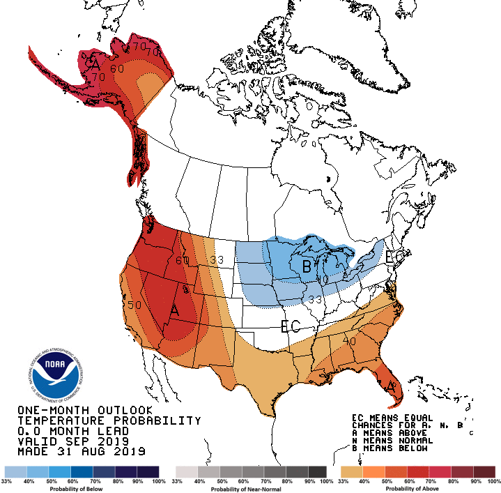
Last week, NOAA's Climate Prediction Center updated their outlook for September. Warmth is still expected across much of the nation, especially in the Southeast and West. The Northeast and Great Lakes were removed from the warmer than normal forecast, as an area of below average temperatures were expanded to include the Northern Plains and Great Lakes.
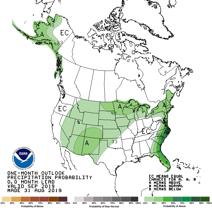
 Most of the Plains are still expected to see a wetter than average month and this has been expanded to include the Southwest. Another area of above average precipitation has been included for most of the Eastern Seaboard and portions of the Southeast.
 Model guidance, statistical tools based on global patterns, and the influences of current soil moisture and coastal sea surface conditions were the main influences of the September outlook. The Climate Prediction Center is expecting a ridge to dominate much of the Western U.S., leading to above average temperatures. The arrival of Hurricane Dorian lead to the above average rainfall forecast for much of the East Coast.
The colder than average forecast in the Northern Plains and Great Lakes is supported by wetter than normal soil moisture conditions and a northerly flow east of the ridge, leading to troughs and more active Jet Stream over the region.
For WeatherNation: Meteorologist Mace Michaels
 Most of the Plains are still expected to see a wetter than average month and this has been expanded to include the Southwest. Another area of above average precipitation has been included for most of the Eastern Seaboard and portions of the Southeast.
 Model guidance, statistical tools based on global patterns, and the influences of current soil moisture and coastal sea surface conditions were the main influences of the September outlook. The Climate Prediction Center is expecting a ridge to dominate much of the Western U.S., leading to above average temperatures. The arrival of Hurricane Dorian lead to the above average rainfall forecast for much of the East Coast.
The colder than average forecast in the Northern Plains and Great Lakes is supported by wetter than normal soil moisture conditions and a northerly flow east of the ridge, leading to troughs and more active Jet Stream over the region.
For WeatherNation: Meteorologist Mace Michaels
Model guidance, statistical tools based on global patterns, and the influences of current soil moisture and coastal sea surface conditions were the main influences of the September outlook. The Climate Prediction Center is expecting a ridge to dominate much of the Western U.S., leading to above average temperatures. The arrival of Hurricane Dorian lead to the above average rainfall forecast for much of the East Coast.
The colder than average forecast in the Northern Plains and Great Lakes is supported by wetter than normal soil moisture conditions and a northerly flow east of the ridge, leading to troughs and more active Jet Stream over the region.
For WeatherNation: Meteorologist Mace MichaelsAll Weather News
More