Using GOES Satellites to Map the California Wildfires
Special Stories
13 Nov 2018 9:06 AM
[NASA] California continues to be plagued by wildfires — including the Woolsey Fire near Los Angeles and the Camp Fire in Northern California, now one of the deadliest in the state's history. NASA satellites are observing these fires — and the damage they're leaving behind — from space.
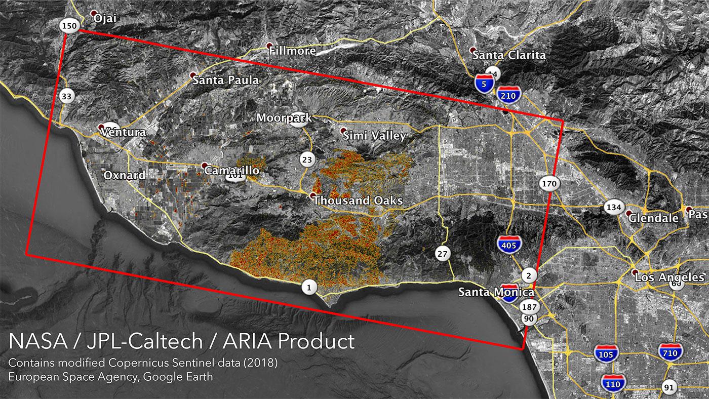
The Advanced Rapid Imaging and Analysis (ARIA) team at NASA's Jet Propulsion Laboratory in Pasadena, California, produced new damage maps using synthetic aperture radar images from the Copernicus Sentinel-1 satellites. The first map shows areas likely damaged by the Woolsey Fire as of Sunday, Nov. 11. It covers an area of about 50 miles by 25 miles (80 km by 40 km) — framed by the red polygon. The color variation from yellow to red indicates increasing ground surface change, or damage.
 [The Advanced Rapid Imaging and Analysis (ARIA) team at NASA's Jet Propulsion Laboratory in Pasadena, California, created these Damage Proxy Maps (DPMs) depicting areas in California likely damaged by the Woolsey and Camp Fires.]
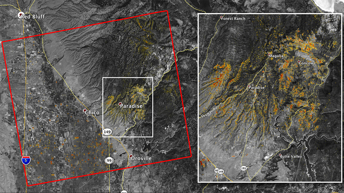
The second map (above) shows damage from the Camp Fire in Northern California as of Saturday, Nov. 10. It depicts an area of about 55 miles by 48 miles (88 km by 77 km) and includes the city of Paradise, one of the most devastated areas. Like the previous map, red areas show the most severe surface change, or damage. The ARIA team compared the data for both images to the Google Crisismap for preliminary validation.
Although the maps may be less reliable over vegetated terrain, like farmland, they can help officials and first responders identify heavily damaged areas and allocate resources as needed.
[The Advanced Rapid Imaging and Analysis (ARIA) team at NASA's Jet Propulsion Laboratory in Pasadena, California, created these Damage Proxy Maps (DPMs) depicting areas in California likely damaged by the Woolsey and Camp Fires.]
The second map (above) shows damage from the Camp Fire in Northern California as of Saturday, Nov. 10. It depicts an area of about 55 miles by 48 miles (88 km by 77 km) and includes the city of Paradise, one of the most devastated areas. Like the previous map, red areas show the most severe surface change, or damage. The ARIA team compared the data for both images to the Google Crisismap for preliminary validation.
Although the maps may be less reliable over vegetated terrain, like farmland, they can help officials and first responders identify heavily damaged areas and allocate resources as needed.
 More information about ARIA is available at https://aria.jpl.nasa.gov/
Edited for WeatherNation by Meteorologist Mace Michaels
More information about ARIA is available at https://aria.jpl.nasa.gov/
Edited for WeatherNation by Meteorologist Mace Michaels
[The Advanced Rapid Imaging and Analysis (ARIA) team at NASA's Jet Propulsion Laboratory in Pasadena, California, created these Damage Proxy Maps (DPMs) depicting areas in California likely damaged by the Woolsey and Camp Fires.]
The second map (above) shows damage from the Camp Fire in Northern California as of Saturday, Nov. 10. It depicts an area of about 55 miles by 48 miles (88 km by 77 km) and includes the city of Paradise, one of the most devastated areas. Like the previous map, red areas show the most severe surface change, or damage. The ARIA team compared the data for both images to the Google Crisismap for preliminary validation.
Although the maps may be less reliable over vegetated terrain, like farmland, they can help officials and first responders identify heavily damaged areas and allocate resources as needed.
More information about ARIA is available at https://aria.jpl.nasa.gov/
Edited for WeatherNation by Meteorologist Mace MichaelsAll Weather News
More
Heavy Rain Returns to Texas This Weekend
It has been over a week since the devastating
13 Jul 2025 3:15 AM

Timeline: How Catastrophic Flooding Unfolded in Texas Hill Country
TEXAS - Catastrophic flooding devastated port
13 Jul 2025 3:10 AM

Watching the Gulf and Atlantic for Tropical Development, CSU Updates Seasonal Forecast
BREAKING: The National Hurricane Center is no
13 Jul 2025 3:00 AM

Heavy Rain, Flooding Threat Returns to Florida
Keep the rain boots handy in Florida - heavy
13 Jul 2025 2:50 AM

Building Heat for West Coast Next Week
High pressure is moving off the California co
13 Jul 2025 2:50 AM

Severe Storm Risk Pushes into the Great Lakes, Ohio Valley
Friday was another busy day with severe weath
12 Jul 2025 8:00 PM

Storms Return From the Front Range to Texas
Moisture is moving back into the Central and
12 Jul 2025 2:50 AM