Wintry Weekend: Increasing Chances for Northeast Snowfall

Special Stories
15 Feb 2018 3:45 PM
There is a rising likelihood for accumulating snowfall this weekend across parts of the Northeast. Here are the details:
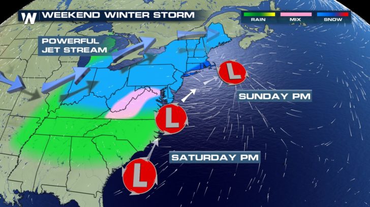 The track of the expected low pressure system to bring light to moderate snowfall to parts of the Northeast Saturday-Sunday, February 17-18
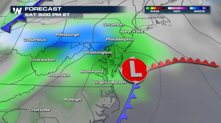 Forecast map on Saturday, February 17 where gray represents clouds, green represents rain, and blue represents snow.
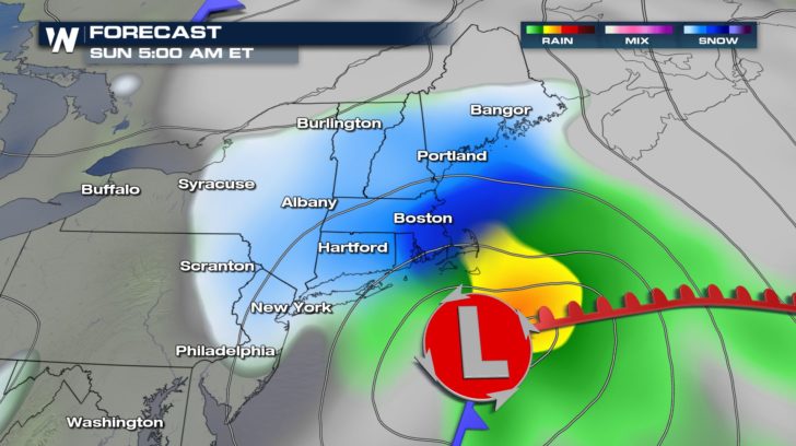 Forecast map on Sunday, February 18 where gray represents clouds, green represents rain, and blue represents snow.
How much snow can *you* expect? Well it ultimately depends on the surface temperature, air temperature, and track/position of this low pressure center. These will likely change, however here is an estimate:
Forecast map on Sunday, February 18 where gray represents clouds, green represents rain, and blue represents snow.
How much snow can *you* expect? Well it ultimately depends on the surface temperature, air temperature, and track/position of this low pressure center. These will likely change, however here is an estimate:
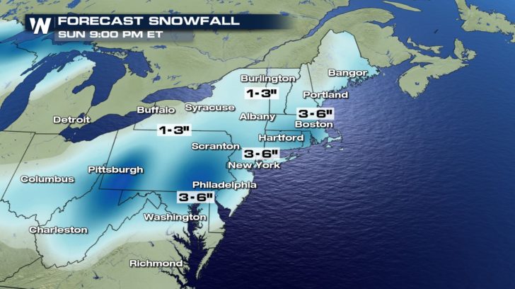 Snowfall forecast from Saturday to Sunday, February 17-18, 2018. *Likely to change slightly*
As we get closer to the event we will have a clearer picture of what you can expect, how much snowfall, and the potential impacts from this quick-moving weather system.
For WeatherNation, Meteorologist Steve Glazier
Snowfall forecast from Saturday to Sunday, February 17-18, 2018. *Likely to change slightly*
As we get closer to the event we will have a clearer picture of what you can expect, how much snowfall, and the potential impacts from this quick-moving weather system.
For WeatherNation, Meteorologist Steve Glazier
- When: Saturday afternoon through Sunday afternoon
- Where: Ohio Valley to Virginia northeastward to New England
- How Much: *As it stands now* One to three inches for most and up to six inches closer to the coast
- What precip: Precipitation mainly falls as a mix of either rain or snow with limited sleet/freezing rain
- Impacts: Still to be determined fully, however some slick roadways and slower travel can be expected
The track of the expected low pressure system to bring light to moderate snowfall to parts of the Northeast Saturday-Sunday, February 17-18
Forecast map on Saturday, February 17 where gray represents clouds, green represents rain, and blue represents snow.
Forecast map on Sunday, February 18 where gray represents clouds, green represents rain, and blue represents snow.
How much snow can *you* expect? Well it ultimately depends on the surface temperature, air temperature, and track/position of this low pressure center. These will likely change, however here is an estimate:
Snowfall forecast from Saturday to Sunday, February 17-18, 2018. *Likely to change slightly*
As we get closer to the event we will have a clearer picture of what you can expect, how much snowfall, and the potential impacts from this quick-moving weather system.
For WeatherNation, Meteorologist Steve GlazierAll Weather News
More
Hurricane Center Monitoring Florida for Tropical Development
Residents and visitors to the Southeast will
30 Jun 2025 10:00 PM

Barry Makes Landfall, Watching Flossie Next
While the Eastern Pacific has made most of th
30 Jun 2025 9:40 PM

Severe Storms For the East Coast Through Tuesday
Frontal systems have been crossing the northe
30 Jun 2025 9:00 PM

Severe Weather Threat Continues in the Midwest
It has been an active, severe season across t
30 Jun 2025 9:00 PM


Where Rain Could Dampen Holiday Travel Plans
AAA is expecting over 70 million travelers to
30 Jun 2025 3:00 PM

Thunderstorms Possible in the Southeast Overnight
SOUTHEAST - Strong thunderstorms have develop
28 Jun 2025 2:40 AM