The 2018 Hurricane Season is Underway with Alberto and Aletta
Special Stories
12 Jun 2018 7:08 AM
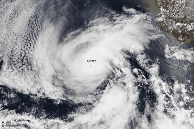
[Suomi NPP satellite image taken of the eastern Pacific Ocean on June 8, 2018. Hurricane Aletta became the first named storm of the 2018 eastern Pacific hurricane season. Aletta rapidly intensified from a Category 1 storm on June 7 to a Category 4 storm on June 8. NOAA Climate image using data provided by the NOAA Visualization Laboratory.]
From NOAA by Tom Di Liberto
Over the past couple of weeks, the first storms of the Atlantic and eastern Pacific Hurricane seasons roared into existence with one already making landfall in the United States along the Florida Panhandle.
In the Atlantic basin, the first named storm of the 2018 Atlantic Hurricane Season rained on a lot of parades over Memorial Day weekend as Alberto made landfall over the panhandle of Florida.
Alberto actually was a subtropical storm when it made landfall, meaning that it didn’t exactly have the scientific characteristics associated with a tropical system. But that doesn’t mean that its impacts were any less.
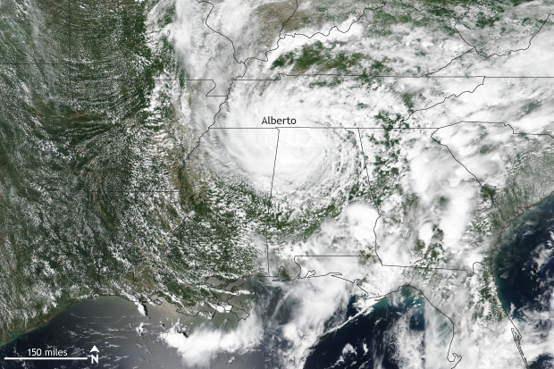 [Suomi NPP satellite image taken of the southeast United States on May 29, 2018. Subtropical storm Alberto became the first named storm of the 2018 Atlantic hurricane season. Oddly, Alberto became better organized as a storm after landfall, and it was classified as a tropical depression. NOAA Climate image using data provided by the NOAA Visualization Laboratory.]
Alberto at landfall had winds of around 45 miles per hour (mph), which was down from its peak of 60 mph. With that wind came heavy rain: nearly 9 inches fell in Florida, with 2-4 inches across much of the rest of the Southeast.
The really astounding thing about Alberto, though, was that it transformed from a disorganized storm to something much more organized after it made landfall. That’s right: it was after Alberto moved onshore that the storm looked more like an actual tropical storm. It was over land on May 29 that the Weather Prediction Center called Alberto a “tropical depression” for the first time.
Alberto moved north through the Midwest, maintaining tropical status even as it moved into Indiana and the Great Lakes region. Eventually, Alberto weakened and dissipated, but not before dropping plenty of rain and serving as quite an odd first named storm of the year.
[Suomi NPP satellite image taken of the southeast United States on May 29, 2018. Subtropical storm Alberto became the first named storm of the 2018 Atlantic hurricane season. Oddly, Alberto became better organized as a storm after landfall, and it was classified as a tropical depression. NOAA Climate image using data provided by the NOAA Visualization Laboratory.]
Alberto at landfall had winds of around 45 miles per hour (mph), which was down from its peak of 60 mph. With that wind came heavy rain: nearly 9 inches fell in Florida, with 2-4 inches across much of the rest of the Southeast.
The really astounding thing about Alberto, though, was that it transformed from a disorganized storm to something much more organized after it made landfall. That’s right: it was after Alberto moved onshore that the storm looked more like an actual tropical storm. It was over land on May 29 that the Weather Prediction Center called Alberto a “tropical depression” for the first time.
Alberto moved north through the Midwest, maintaining tropical status even as it moved into Indiana and the Great Lakes region. Eventually, Alberto weakened and dissipated, but not before dropping plenty of rain and serving as quite an odd first named storm of the year.
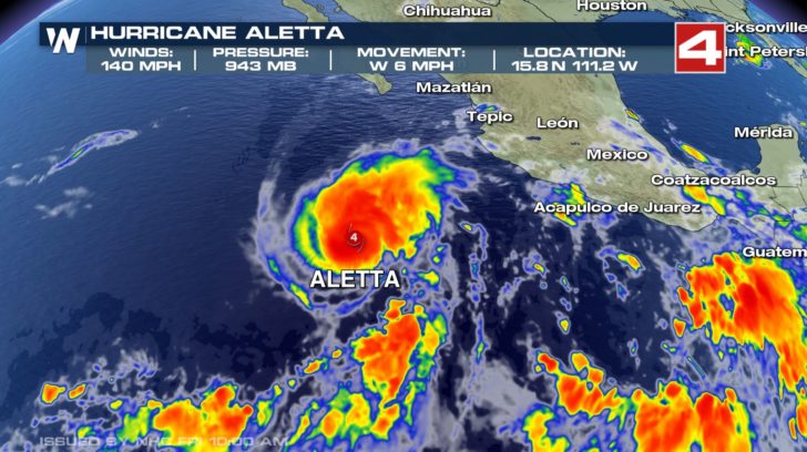 [Hurricane Aletta reached category 4 status on June 8th. It has since weakened and is no longer tropical.]
Meanwhile, it took until the first week of June for the eastern Pacific Ocean to see its first named storm of the year. But once Aletta formed and got its act together, it became the first hurricane of the year, dwarfing Alberto in strength.
Aletta’s ascent was quick. It became a named storm on June 6, a hurricane on June 7, and a major hurricane on June 8. In just 18 hours between June 7 and 8, Aletta rapidly intensified from a Category 1 to a Category 4 storm with 140-mph winds. Luckily, unlike Alberto, Aletta has no inclination to impact land.
[Hurricane Aletta reached category 4 status on June 8th. It has since weakened and is no longer tropical.]
Meanwhile, it took until the first week of June for the eastern Pacific Ocean to see its first named storm of the year. But once Aletta formed and got its act together, it became the first hurricane of the year, dwarfing Alberto in strength.
Aletta’s ascent was quick. It became a named storm on June 6, a hurricane on June 7, and a major hurricane on June 8. In just 18 hours between June 7 and 8, Aletta rapidly intensified from a Category 1 to a Category 4 storm with 140-mph winds. Luckily, unlike Alberto, Aletta has no inclination to impact land.
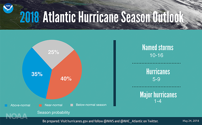 Now that we are in June and have passed the official start of the hurricane season, it might be prudent to look back at this year’s preliminary Atlantic and Pacific hurricane outlooks, issued in late May by NOAA’s Climate Prediction Center.
For the Atlantic Ocean, of the three possible seasonal outcomes (above-normal, near-normal, or below-normal activity), climate scientists forecast that a near-normal season is most likely with a 40% chance, but the odds of an above-normal season are running a close second, with a 35% chance. The least likely outcome is a below-normal hurricane season, but with odds of 25%, it is certainly not out of the question.
Combining probabilities, there is a 75% chance of a near to above-normal hurricane season. Based on statistics from previous average and above-average seasons, scientists predict 10-16 named storms, 5-9 of them hurricanes, and 1-4 of those becoming major (Category 3 or higher).
Now that we are in June and have passed the official start of the hurricane season, it might be prudent to look back at this year’s preliminary Atlantic and Pacific hurricane outlooks, issued in late May by NOAA’s Climate Prediction Center.
For the Atlantic Ocean, of the three possible seasonal outcomes (above-normal, near-normal, or below-normal activity), climate scientists forecast that a near-normal season is most likely with a 40% chance, but the odds of an above-normal season are running a close second, with a 35% chance. The least likely outcome is a below-normal hurricane season, but with odds of 25%, it is certainly not out of the question.
Combining probabilities, there is a 75% chance of a near to above-normal hurricane season. Based on statistics from previous average and above-average seasons, scientists predict 10-16 named storms, 5-9 of them hurricanes, and 1-4 of those becoming major (Category 3 or higher).
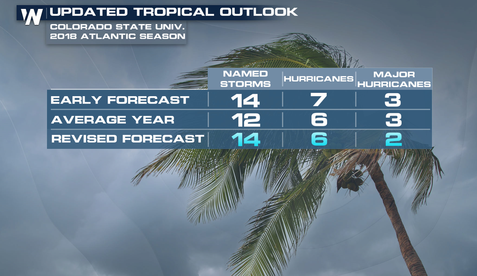 Meteorologists at Colorado State recently updated their 2018 hurricane season forecast on June 1st. They slightly lowered their total storm numbers from the previous forecast issued earlier in April, now calling for 14 named storms (including Alberto), 6 hurricanes, and 2 major hurricanes.
In contrast, for the eastern Pacific Ocean, NOAA scientists slightly favor an above-average hurricane season (45% chance) with 14-20 named storms, 7-12 hurricanes, and 3-7 major hurricanes.
Meteorologists at Colorado State recently updated their 2018 hurricane season forecast on June 1st. They slightly lowered their total storm numbers from the previous forecast issued earlier in April, now calling for 14 named storms (including Alberto), 6 hurricanes, and 2 major hurricanes.
In contrast, for the eastern Pacific Ocean, NOAA scientists slightly favor an above-average hurricane season (45% chance) with 14-20 named storms, 7-12 hurricanes, and 3-7 major hurricanes.
[Suomi NPP satellite image taken of the southeast United States on May 29, 2018. Subtropical storm Alberto became the first named storm of the 2018 Atlantic hurricane season. Oddly, Alberto became better organized as a storm after landfall, and it was classified as a tropical depression. NOAA Climate image using data provided by the NOAA Visualization Laboratory.]
Alberto at landfall had winds of around 45 miles per hour (mph), which was down from its peak of 60 mph. With that wind came heavy rain: nearly 9 inches fell in Florida, with 2-4 inches across much of the rest of the Southeast.
The really astounding thing about Alberto, though, was that it transformed from a disorganized storm to something much more organized after it made landfall. That’s right: it was after Alberto moved onshore that the storm looked more like an actual tropical storm. It was over land on May 29 that the Weather Prediction Center called Alberto a “tropical depression” for the first time.
Alberto moved north through the Midwest, maintaining tropical status even as it moved into Indiana and the Great Lakes region. Eventually, Alberto weakened and dissipated, but not before dropping plenty of rain and serving as quite an odd first named storm of the year.
Heading west to the Pacific Ocean
[Hurricane Aletta reached category 4 status on June 8th. It has since weakened and is no longer tropical.]
Meanwhile, it took until the first week of June for the eastern Pacific Ocean to see its first named storm of the year. But once Aletta formed and got its act together, it became the first hurricane of the year, dwarfing Alberto in strength.
Aletta’s ascent was quick. It became a named storm on June 6, a hurricane on June 7, and a major hurricane on June 8. In just 18 hours between June 7 and 8, Aletta rapidly intensified from a Category 1 to a Category 4 storm with 140-mph winds. Luckily, unlike Alberto, Aletta has no inclination to impact land.
What does the outlook for the hurricane season look like?
Now that we are in June and have passed the official start of the hurricane season, it might be prudent to look back at this year’s preliminary Atlantic and Pacific hurricane outlooks, issued in late May by NOAA’s Climate Prediction Center.
For the Atlantic Ocean, of the three possible seasonal outcomes (above-normal, near-normal, or below-normal activity), climate scientists forecast that a near-normal season is most likely with a 40% chance, but the odds of an above-normal season are running a close second, with a 35% chance. The least likely outcome is a below-normal hurricane season, but with odds of 25%, it is certainly not out of the question.
Combining probabilities, there is a 75% chance of a near to above-normal hurricane season. Based on statistics from previous average and above-average seasons, scientists predict 10-16 named storms, 5-9 of them hurricanes, and 1-4 of those becoming major (Category 3 or higher).
Meteorologists at Colorado State recently updated their 2018 hurricane season forecast on June 1st. They slightly lowered their total storm numbers from the previous forecast issued earlier in April, now calling for 14 named storms (including Alberto), 6 hurricanes, and 2 major hurricanes.
In contrast, for the eastern Pacific Ocean, NOAA scientists slightly favor an above-average hurricane season (45% chance) with 14-20 named storms, 7-12 hurricanes, and 3-7 major hurricanes.
Climate influences on the hurricane season
We are currently in an ENSO-neutral state in the Pacific Ocean. Forecasts suggest that either this neutral state will continue through the hurricane season or else a weak El Niño will develop by fall. El Niños tend to reduce hurricane activity in the Atlantic Ocean and increase it in the eastern Pacific. On top of that, sea surface temperatures in the prime region for hurricane development in the Atlantic Ocean are below normal. This also would reduce the amount of hurricanes. Taken together, these influences would favor at least an average Atlantic hurricane season, if not a below-average one. On the flip side, however, we are still currently in the midst of a high-activity era for Atlantic hurricanes that began in 1995. This high-activity era is associated with the warm phase of the Atlantic Multi-Decadal Oscillation (AMO). The AMO refer to cyclical changing of sea surface temperature patterns across the Atlantic Ocean that last 25-40 years, on average. Add all of these factors together and you get a slight tilt in the odds towards a more active season in the eastern Pacific and a tilt towards a near-average in the Atlantic, although certainly no slam dunk in either case. Of course, it just takes one storm to cause devastating impacts so if you find yourself in a hurricane-prone area, it is important to know what to do now. It’s never too early to begin your preparations. Edited for WeatherNation by Meteorologist Mace MichaelsAll Weather News
More
Heavy Rain Returns to Texas This Weekend
It's been a week since the devastating floods
12 Jul 2025 3:10 AM

Medium Range Tropics Forecast Favors Gulf, CSU Updates Seasonal Forecast
While the Atlantic appears quiet, conditions
12 Jul 2025 3:05 AM

Elevated Tornado Risk Targets the Midwest Friday
Friday was another busy day with severe weath
12 Jul 2025 3:00 AM

Storms Return From the Front Range to Texas
Moisture is moving back into the Central and
12 Jul 2025 2:50 AM

Timeline: How Catastrophic Flooding Unfolded in Texas Hill Country
TEXAS - Catastrophic flooding devastated port
11 Jul 2025 10:00 AM

Severe Thunderstorms Expected Across the East Coast
The severe weather and flood threat continues
11 Jul 2025 2:35 AM

Ruidoso Flash Flooding - Record Crest for the Rio Ruidoso River
A slow-moving monsoonal thunderstorm develope
10 Jul 2025 1:55 AM