Flood Threat Continues Across Upper Midwest
Top Stories
2 Sep 2018 6:24 PM
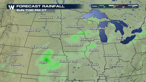
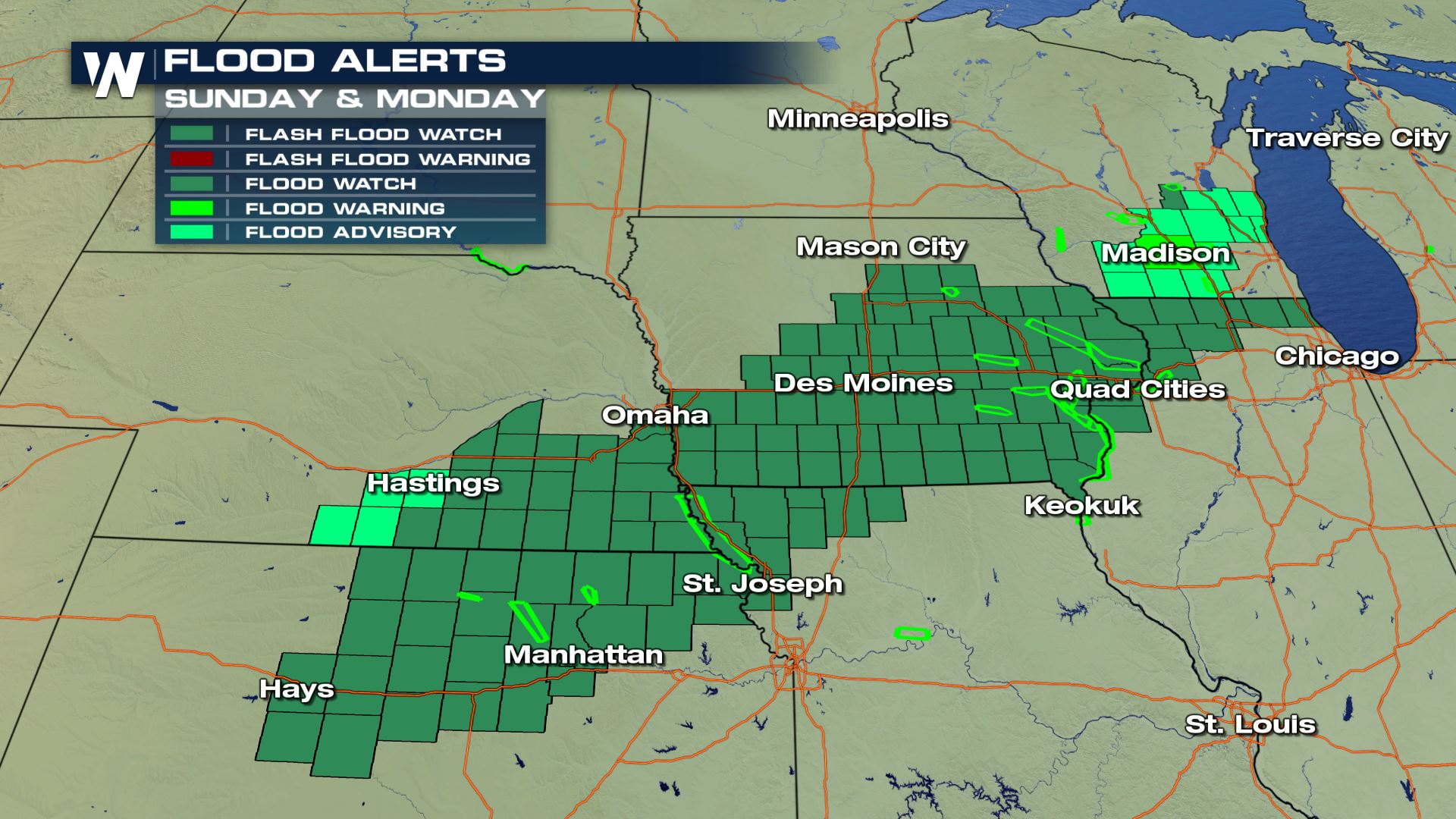
We have been dealing with constant heavy rain and severe storm for several weeks now across much of the Upper Midwest. We have widespread Flood Alerts for Sunday evening and into Monday morning. We will have rounds of showers and storms across the region into Monday from a stalled out frontal boundary. More heavy rain showers paired with already saturated soil will lead to an elevated risk for flash flooding.
 https://twitter.com/NWSDesMoines/status/1036347159405318147
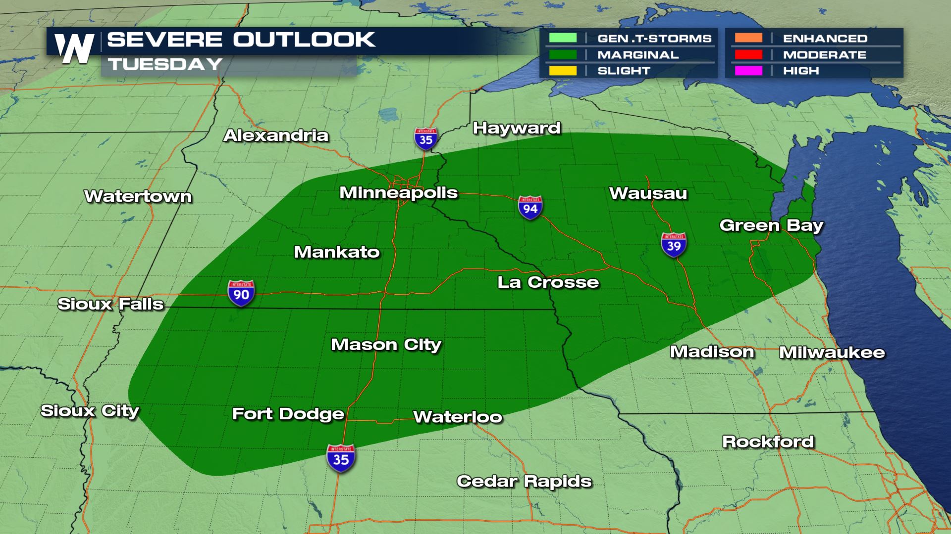
Another low pressure system works into the area on Tuesday. This returns the risk for severe storms as well as more heavy rain.
https://twitter.com/NWSDesMoines/status/1036347159405318147
Another low pressure system works into the area on Tuesday. This returns the risk for severe storms as well as more heavy rain.
 Ahead of the cold front, Iowa, southern Minnesota and Wisconsin will be the in warm sector of the system. This means that it will be very warm (upper 80s and lower 90s) with a lot of humidity. All that humidity is just ample moisture for any storms to tap in to and produce heavy rain.
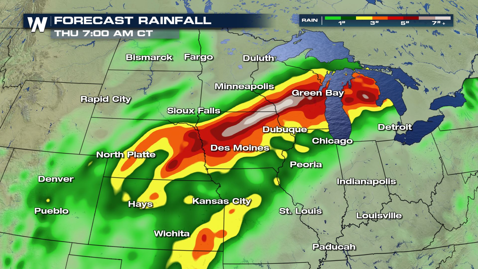
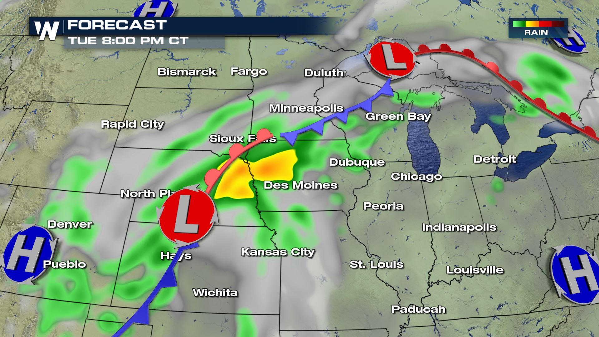 As we head into the first half of the week, Many spots from Nebraska to Michigan could see several inches of rain. Widespread, some spots could see 2-4" of rain and locally up to 6"+.
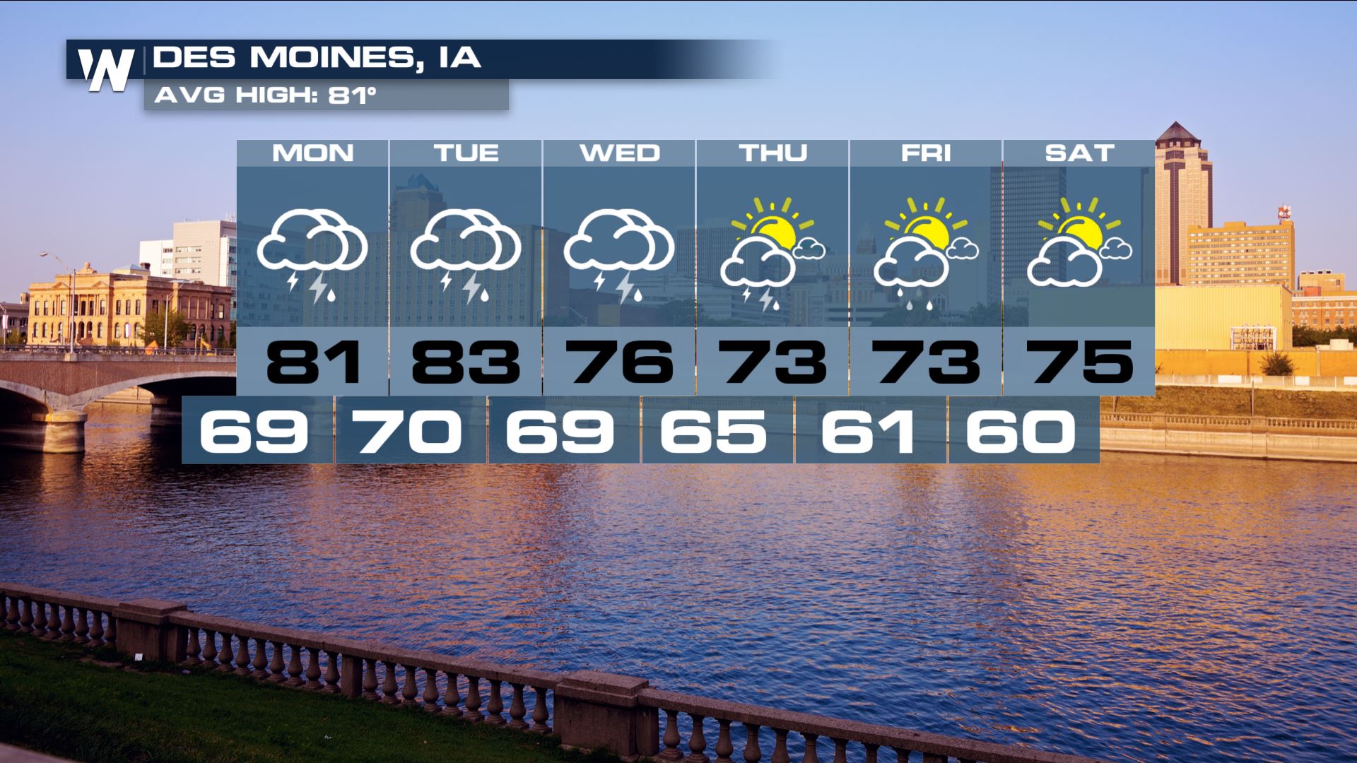
 For Des Moines, the heaviest of the rain will be Monday through Wednesday before this system starts to pull off toward the northeast. Things will become a bit drier come end of the week as high pressure slides in.
 For Madison, most of Tuesday will be dry but the heavy rain will work in in the late afternoon and evening hours and last into Wednesday.
 Be sure to stay weather aware and pay attention to an Flash Flood Watches or Warnings that may be issued in your area.
For WeatherNation, Meteorologist Kate Mantych.
Be sure to stay weather aware and pay attention to an Flash Flood Watches or Warnings that may be issued in your area.
For WeatherNation, Meteorologist Kate Mantych.
https://twitter.com/NWSDesMoines/status/1036347159405318147
Another low pressure system works into the area on Tuesday. This returns the risk for severe storms as well as more heavy rain.
Ahead of the cold front, Iowa, southern Minnesota and Wisconsin will be the in warm sector of the system. This means that it will be very warm (upper 80s and lower 90s) with a lot of humidity. All that humidity is just ample moisture for any storms to tap in to and produce heavy rain.
As we head into the first half of the week, Many spots from Nebraska to Michigan could see several inches of rain. Widespread, some spots could see 2-4" of rain and locally up to 6"+.
For Des Moines, the heaviest of the rain will be Monday through Wednesday before this system starts to pull off toward the northeast. Things will become a bit drier come end of the week as high pressure slides in.
For Madison, most of Tuesday will be dry but the heavy rain will work in in the late afternoon and evening hours and last into Wednesday.
Be sure to stay weather aware and pay attention to an Flash Flood Watches or Warnings that may be issued in your area.
For WeatherNation, Meteorologist Kate Mantych.All Weather News
More


More Storms for the East Through Monday
A low-pressure system that moved through the
3 Aug 2026 1:50 AM

After Reaching Category 5, Genevieve Weakens in the Pacific
PacificGenevieve formed last Friday south of
3 Aug 2026 12:30 AM

Flooding, Severe Storms Target the Midwest Again
After an active week of storms across the nor
1 Aug 2026 1:40 AM

Flooding Risk Increases as Heavy Rain Targets the Tri-State Area
Tuesday, heavy rainfall moved across the Nort
30 Jul 2026 12:25 AM

Severe Weather: Energy From the Midwest Now in the Southeast
UPPER MIDWEST - Through Monday, dangerous tor
29 Jul 2026 10:30 PM