August and Summer Recap: Hot, Dry and Destructive
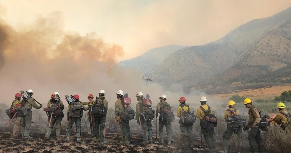
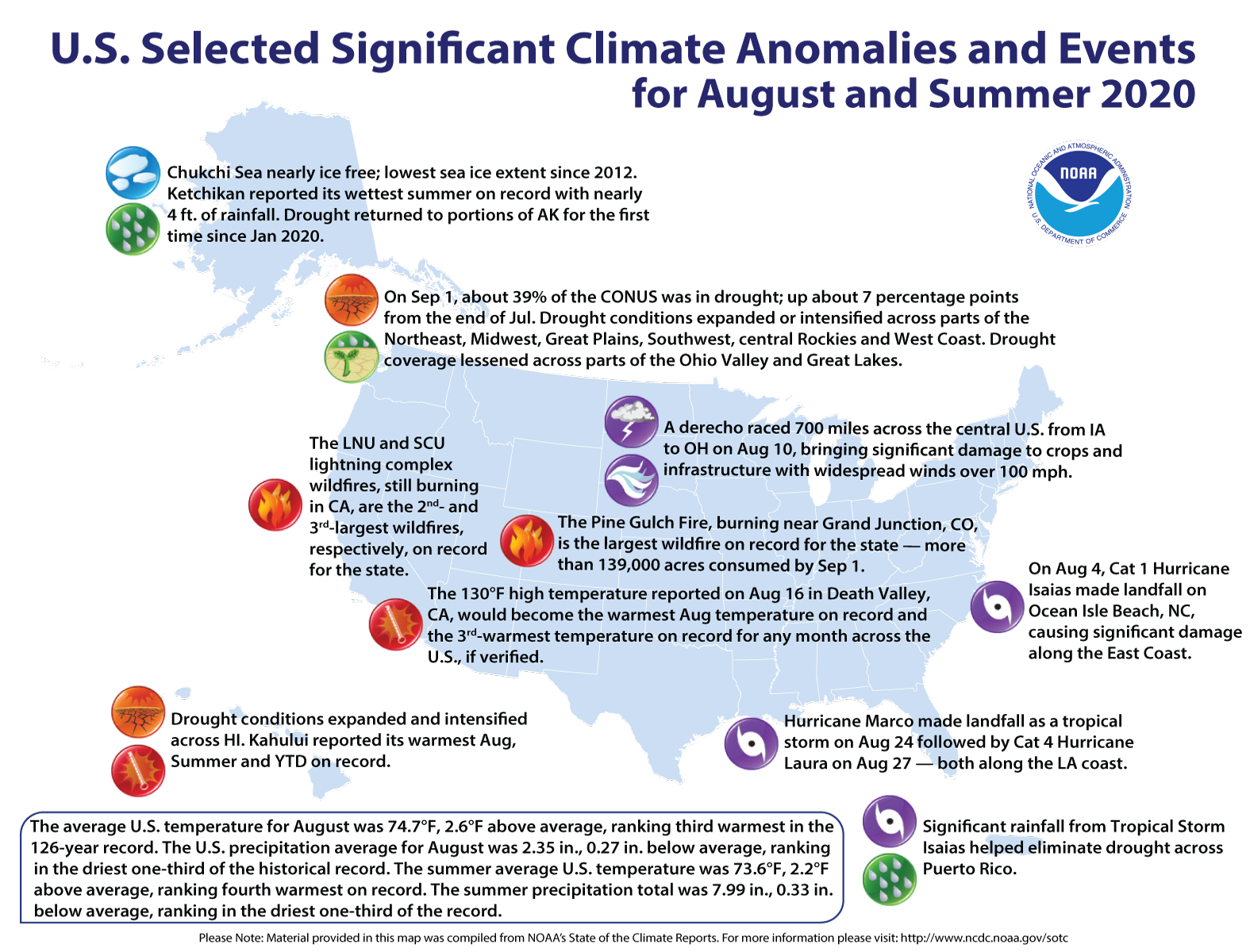
[Firefighters on the march: The Pine Gulch Fire, smoke of which shown here, was started by a lightning strike on July 31, 2020, approximately 18 miles north of Grand Junction, Colorado. According to InciWeb, as of August 27, 2020, the Pine Gulch Fire became the largest wildfire in Colorado State history, surpassing the Hayman Fire that burned near Colorado Springs in the summer of 2002. (Bureau of Land Management-Colorado, via InciWeb and National Interagency Fire Center)]
[Written by NOAA] August 2020 will be remembered for its extreme heat and violent weather: The U.S. endured heat waves, hurricanes, a devastating derecho and raging wildfires out West.
Meteorological summer — June through August’s end — was a standout: It ranked 4th hottest and in the driest one-third of all summers in the historical record.
Here are more highlights from NOAA’s latest monthly U.S. climate report:
CLIMATE BY THE NUMBERS
August 2020
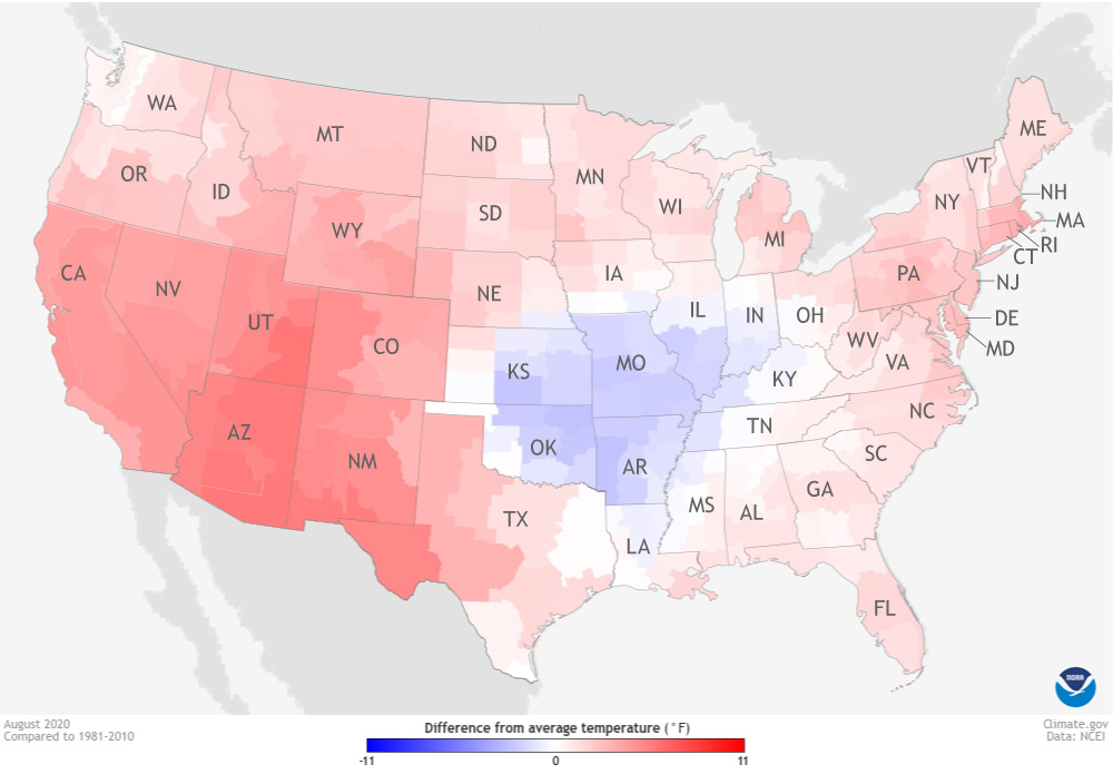
The average temperature for August across the contiguous U.S. was 74.7 degrees F (2.6 degrees above the 20th-century average) and ranked third-hottest August on record.
Arizona, California, Colorado, Nevada, New Mexico and Utah each had their warmest August on record. In particular, Phoenix, Arizona, had its hottest month ever recorded, with an average temperature of 99.1 degrees F.
Also on August 16, Death Valley in California reported a high temperature of 130 degrees F. If verified, this temperature would be the hottest August temperature on record for the U.S.
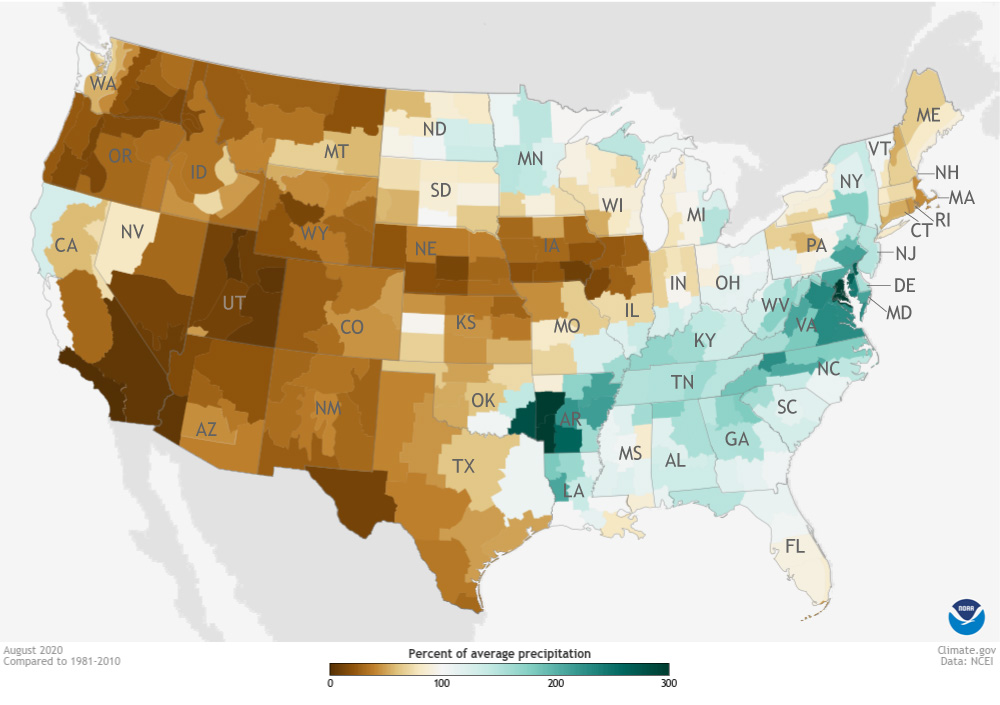
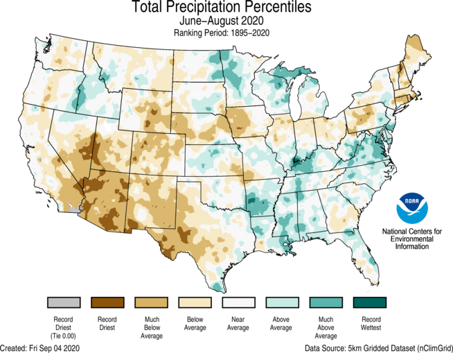
The average August precipitation for the contiguous U.S. was 2.35 inches (0.27 of an inch below average), which put the month in the driest third of the 126-year record.
Arizona, Nebraska and Utah ranked driest on record for August, while New Mexico and Iowa ranked second and third driest on record, respectively.
Year to date & meteorological summer
The average U.S. temperature for the year to date (YTD, January through August) was 56.3 degrees F, 2.4 degrees above the 20th-century average. It ended as the 7th-warmest in the YTD record.
The contiguous U.S. has seen 21.64 inches of precipitation for the YTD (0.93 of an inch above the long-term average), placing it in the wettest third of record.
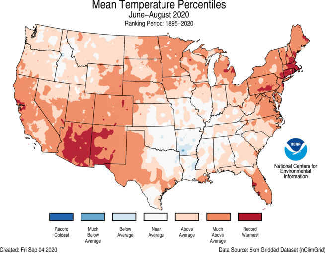
For meteorological summer (June through August), the average temperature for the contiguous U.S. was 73.6 degrees F — 2.2 degrees above the average. Summer 2020 ended with the ranking of 4th-hottest summer on record.
The precipitation total for summer was 7.99 inches (0.33 of an inch below average), which ranked in the driest third of the record.
More notable climate and extreme events
- Two Atlantic hurricanes made landfall.
- Hurricane Isaias struck North Carolina on August 4 and quickly accelerated up the East Coast, bringing widespread damage and power outages across New York, New Jersey and Pennsylvania.
- Hurricane Laura made landfall on August 27 in southwest Louisiana with 150-mph winds. Laura tied the 1856 Louisiana hurricane for having the strongest land-falling winds on record for the state.
- Wildfires blazed. Numerous wildfires burned hundreds of thousands of acres across the West. Lightning from unusual summer thunderstorms sparked the second-,third-, and fourth-largest fires on record in California, while the Pine Gulch Fire, near Grand Junction, Colorado, became the state’s largest wildfire in state history.
- A devastating derecho swept through. On August 10, a line of severe thunderstorms with widespread winds of more than 100 mph, known as a derecho, raced 700 miles across the central U.S. from Iowa to Ohio and brought significant damage to crops and infrastructure.


