Blizzard Conditions Rock Plains; Winds Near 100 mph
Special Stories
13 Mar 2019 4:39 PM
A wild weather day for parts of the Plains, including Colorado, Nebraska, and Kansas with blizzard conditions and record setting pressure drops.
https://youtu.be/u7fhu2FgB3A
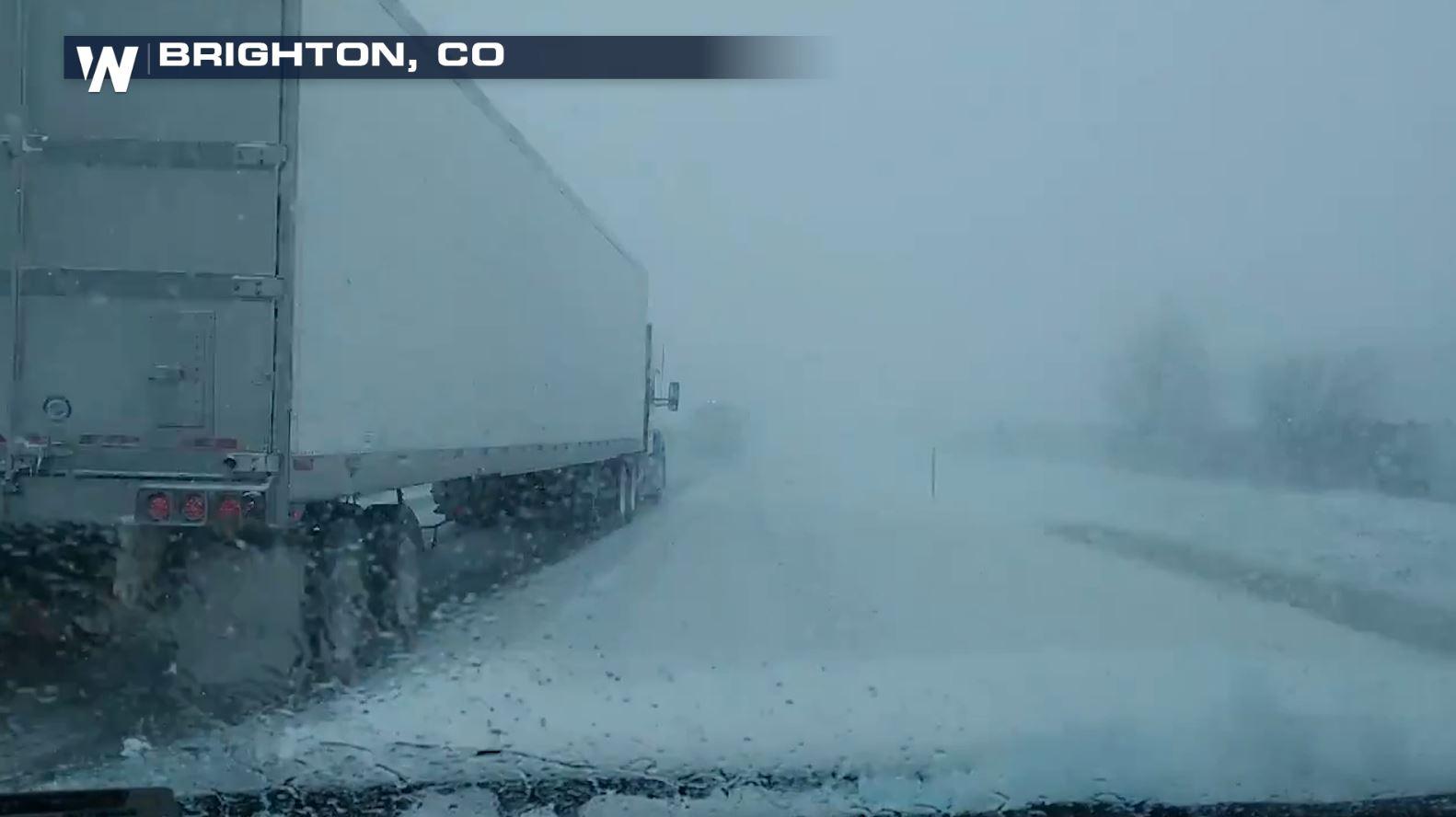
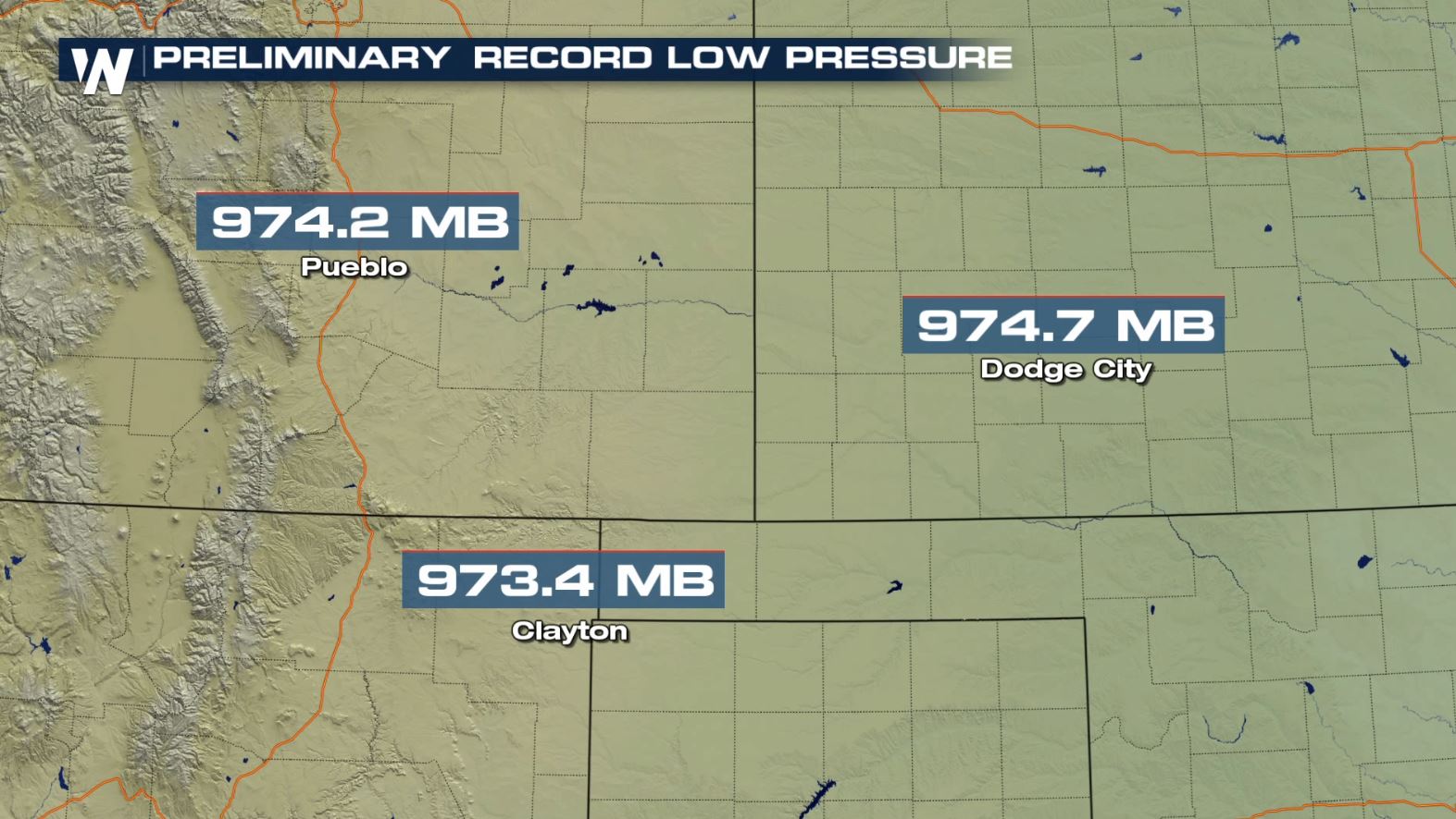
What started as rain early in the morning, quickly changed to snow and high winds as the storm system rapidly intensified. The storm central pressure dropped incredibly fast, a term meteorologists call "bombogenesis". When a storm "bombs out", the pressure drops at least 24 millibars in 24 hours. This storm, dropped more than 30 mb in just 24 hours, setting new state records in Colorado.
WATCH: What is a bomb cyclone?
 Winds quickly ramped up as the storm strengthened. A wind gust of 97 mph was measured at Colorado Springs Airport, according to the National Weather Service in Pueblo. Wind gusts also topped 100 mph in Texas, toppling semi trucks like toys as the powerful storm brought high winds ahead of it from Texas to the Dakotas.
[WATCH: Winds topple semi trucks in Texas high winds]
Conditions in the Denver metro area became treacherous late morning, prompting flight cancellations at the Denver International Airport.
https://twitter.com/WeatherNation/status/1105952995345235968
Major interstates were shut down, including I-25 in Colorado, I-70 from Colorado to Kansas, and I-80 in Nebraska and Wyoming as road conditions became too dangerous for travel.
https://twitter.com/WeatherNation/status/1105886570656067584
https://twitter.com/NickMerianos/status/1105965124966215680
Sadly, a police officer was killed in the storm when he was hit by a car while responding to a crash on I-76 , according to Colorado State Patrol.
As the storm presses northward, blizzard conditions will make travel nearly impossible. Local officials advise those in the path of the storm to stay home and avoid travel if possible.
Stay with WeatherNation as we follow the storm.
Winds quickly ramped up as the storm strengthened. A wind gust of 97 mph was measured at Colorado Springs Airport, according to the National Weather Service in Pueblo. Wind gusts also topped 100 mph in Texas, toppling semi trucks like toys as the powerful storm brought high winds ahead of it from Texas to the Dakotas.
[WATCH: Winds topple semi trucks in Texas high winds]
Conditions in the Denver metro area became treacherous late morning, prompting flight cancellations at the Denver International Airport.
https://twitter.com/WeatherNation/status/1105952995345235968
Major interstates were shut down, including I-25 in Colorado, I-70 from Colorado to Kansas, and I-80 in Nebraska and Wyoming as road conditions became too dangerous for travel.
https://twitter.com/WeatherNation/status/1105886570656067584
https://twitter.com/NickMerianos/status/1105965124966215680
Sadly, a police officer was killed in the storm when he was hit by a car while responding to a crash on I-76 , according to Colorado State Patrol.
As the storm presses northward, blizzard conditions will make travel nearly impossible. Local officials advise those in the path of the storm to stay home and avoid travel if possible.
Stay with WeatherNation as we follow the storm.
All Weather News
More
Wildfire Outbreak in the Pacific Northwest
SPOKANE, WA - On Saturday, August 1st, the Ol
3 Aug 2026 1:55 AM

More Storms for the East Through Monday
A low-pressure system that moved through the
3 Aug 2026 1:50 AM


After Reaching Category 5, Genevieve Weakens in the Pacific
PacificGenevieve formed last Friday south of
3 Aug 2026 12:30 AM

Flooding, Severe Storms Target the Midwest Again
After an active week of storms across the nor
1 Aug 2026 1:40 AM

Flooding Risk Increases as Heavy Rain Targets the Tri-State Area
Tuesday, heavy rainfall moved across the Nort
30 Jul 2026 12:25 AM

Severe Weather: Energy From the Midwest Now in the Southeast
UPPER MIDWEST - Through Monday, dangerous tor
29 Jul 2026 10:30 PM