Climate Prediction Center's February Through April Outlook
Special Stories
21 Jan 2020 10:00 PM
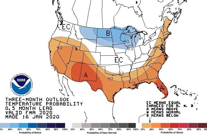
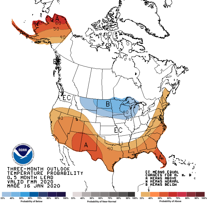
Last week, NOAA's Climate Prediction Center issued their outlook covering February, March, and April. Warmer than normal temperature are forecast from the Eastern Seaboard through the Mississippi Valley and into the Southwest. Winter's grip may hold on a little longer in the Upper Midwest with colder than average weather predicted.
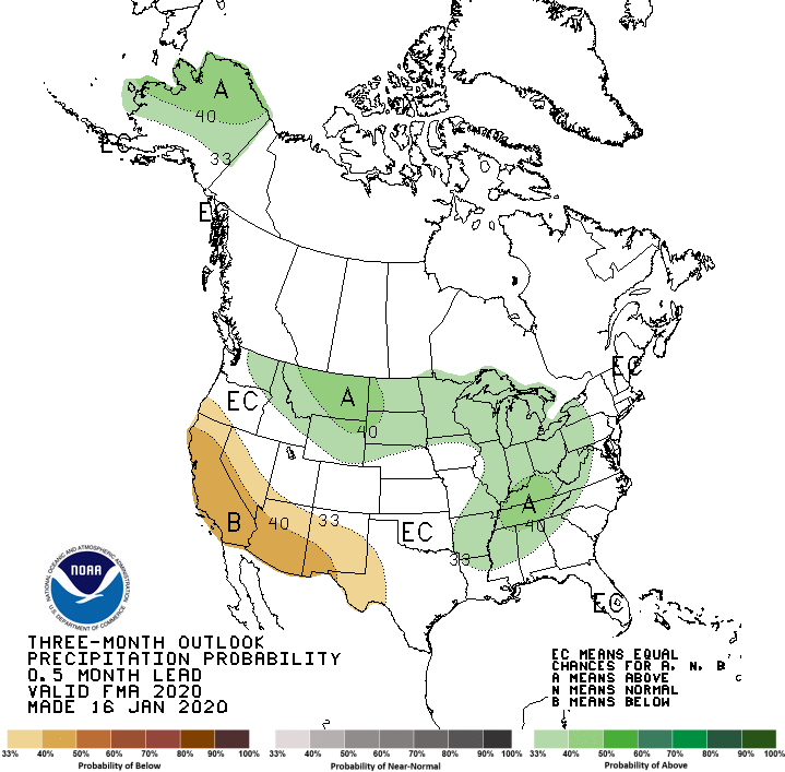
 In the precipitation outlook, wetter than average weather is expected from the Northwest to the Great Lakes and Tennessee Valley. Drier than normal conditions are forecast for the Southwest. This will likely lead to drought conditions persisting and possibly further development from the Four Corners to California and Oregon.
 https://twitter.com/NWSCPC/status/1217809348304363520
The CPC noted that the forecast were based on model guidance and statistical tools. Sea surface temperatures in the Pacific Ocean are near normal, and that is expected to continue. Therefore, El Nino or La Nina will not be in a factor over the coming months.
https://twitter.com/NWSCPC/status/1217809348304363520
The CPC noted that the forecast were based on model guidance and statistical tools. Sea surface temperatures in the Pacific Ocean are near normal, and that is expected to continue. Therefore, El Nino or La Nina will not be in a factor over the coming months.
In the precipitation outlook, wetter than average weather is expected from the Northwest to the Great Lakes and Tennessee Valley. Drier than normal conditions are forecast for the Southwest. This will likely lead to drought conditions persisting and possibly further development from the Four Corners to California and Oregon.
https://twitter.com/NWSCPC/status/1217809348304363520
The CPC noted that the forecast were based on model guidance and statistical tools. Sea surface temperatures in the Pacific Ocean are near normal, and that is expected to continue. Therefore, El Nino or La Nina will not be in a factor over the coming months.All Weather News
More
Heavy Rain Returns to Texas This Weekend
It's been a week since the devastating floods
12 Jul 2025 3:10 AM

Medium Range Tropics Forecast Favors Gulf, CSU Updates Seasonal Forecast
While the Atlantic appears quiet, conditions
12 Jul 2025 3:05 AM

Elevated Tornado Risk Targets the Midwest Friday
Friday was another busy day with severe weath
12 Jul 2025 3:00 AM

Storms Return From the Front Range to Texas
Moisture is moving back into the Central and
12 Jul 2025 2:50 AM

Timeline: How Catastrophic Flooding Unfolded in Texas Hill Country
TEXAS - Catastrophic flooding devastated port
11 Jul 2025 10:00 AM

Severe Thunderstorms Expected Across the East Coast
The severe weather and flood threat continues
11 Jul 2025 2:35 AM

Ruidoso Flash Flooding - Record Crest for the Rio Ruidoso River
A slow-moving monsoonal thunderstorm develope
10 Jul 2025 1:55 AM