Distant Tropical Storms have Ripple Effects on Weather Close to Home

Special Stories
28 Feb 2018 2:17 PM
From Colorado State University
The famously intense tropical rainstorms along the Earth’s equator occur thousands of miles from the United States. But atmospheric scientists know that, like ripples in a pond, tropical weather creates powerful waves in the atmosphere that travel all the way to North America and have major impacts on weather in the U.S.
These far-flung, interconnected weather processes are crucial to making better, longer-term weather predictions than are currently possible. Colorado State University atmospheric scientists, led by professors Libby Barnes and Eric Maloney, are hard at work to address these longer-term forecasting challenges.
In a new paper in npj Climate and Atmospheric Science, the CSU researchers describe a breakthrough in making accurate predictions of weather weeks ahead. They’ve created an empirical model fed by careful analysis of 37 years of historical weather data. Their model centers on the relationship between two well-known global weather patterns: the Madden-Julian Oscillation and the quasi-biennial oscillation.
According to the study, led by former graduate researcher Bryan Mundhenk, the model, using both these phenomena, allows skillful prediction of the behavior of major rain storms, called atmospheric rivers, three and up to five weeks in advance.
 “It’s impressive, considering that current state-of-the-art numerical weather models, such as NOA’s Global Forecast System, or the European Centre for Medium-Range Weather Forecasts’ operational model, are only skillful up to one to two weeks in advance,” says paper co-author Cory Baggett, a postdoctoral researcher in the Barnes and Maloney labs.
The researchers’ chief aim is improving forecast capabilities within the tricky no-man’s land of “subseasonal to seasonal” timescales: roughly three weeks to three months out. Predictive capabilities that far in advance could save lives and livelihoods, from sounding alarms for floods and mudslides to preparing farmers for long dry seasons. Barnes also leads a federal NOAA task force for improving subseasonal to seasonal forecasting, with the goal of sharpening predictions for hurricanes, heat waves, the polar vortex and more.
“It’s impressive, considering that current state-of-the-art numerical weather models, such as NOA’s Global Forecast System, or the European Centre for Medium-Range Weather Forecasts’ operational model, are only skillful up to one to two weeks in advance,” says paper co-author Cory Baggett, a postdoctoral researcher in the Barnes and Maloney labs.
The researchers’ chief aim is improving forecast capabilities within the tricky no-man’s land of “subseasonal to seasonal” timescales: roughly three weeks to three months out. Predictive capabilities that far in advance could save lives and livelihoods, from sounding alarms for floods and mudslides to preparing farmers for long dry seasons. Barnes also leads a federal NOAA task force for improving subseasonal to seasonal forecasting, with the goal of sharpening predictions for hurricanes, heat waves, the polar vortex and more.
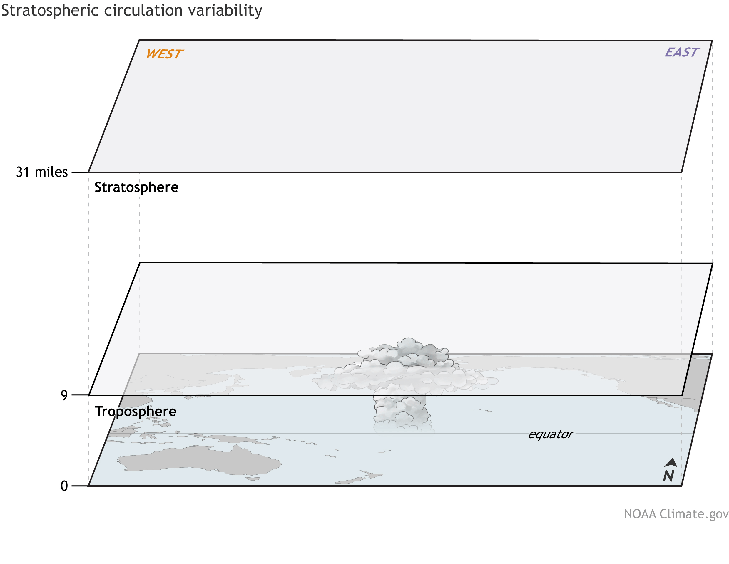 [The wind in the tropical stratosphere shifts between easterlies and westerlies over two to three years. This alternating pattern is called the QBO. Credit: NOAA Climate animation.]
“It would be worthwhile to develop a good understanding of the physical relationship between the Madden-Julian Oscillation and the quasi-biennial oscillation, and see what can be done to improve models’ simulation of this relationship,” Mundhenk said. Another logical extension of their work would be to test how well their model can forecast actual rainfall and wind or other severe weather, such as tornadoes and hail.
Edited for WeatherNation by Meteorologist Mace Michaels
[The wind in the tropical stratosphere shifts between easterlies and westerlies over two to three years. This alternating pattern is called the QBO. Credit: NOAA Climate animation.]
“It would be worthwhile to develop a good understanding of the physical relationship between the Madden-Julian Oscillation and the quasi-biennial oscillation, and see what can be done to improve models’ simulation of this relationship,” Mundhenk said. Another logical extension of their work would be to test how well their model can forecast actual rainfall and wind or other severe weather, such as tornadoes and hail.
Edited for WeatherNation by Meteorologist Mace Michaels
“It’s impressive, considering that current state-of-the-art numerical weather models, such as NOA’s Global Forecast System, or the European Centre for Medium-Range Weather Forecasts’ operational model, are only skillful up to one to two weeks in advance,” says paper co-author Cory Baggett, a postdoctoral researcher in the Barnes and Maloney labs.
The researchers’ chief aim is improving forecast capabilities within the tricky no-man’s land of “subseasonal to seasonal” timescales: roughly three weeks to three months out. Predictive capabilities that far in advance could save lives and livelihoods, from sounding alarms for floods and mudslides to preparing farmers for long dry seasons. Barnes also leads a federal NOAA task force for improving subseasonal to seasonal forecasting, with the goal of sharpening predictions for hurricanes, heat waves, the polar vortex and more.
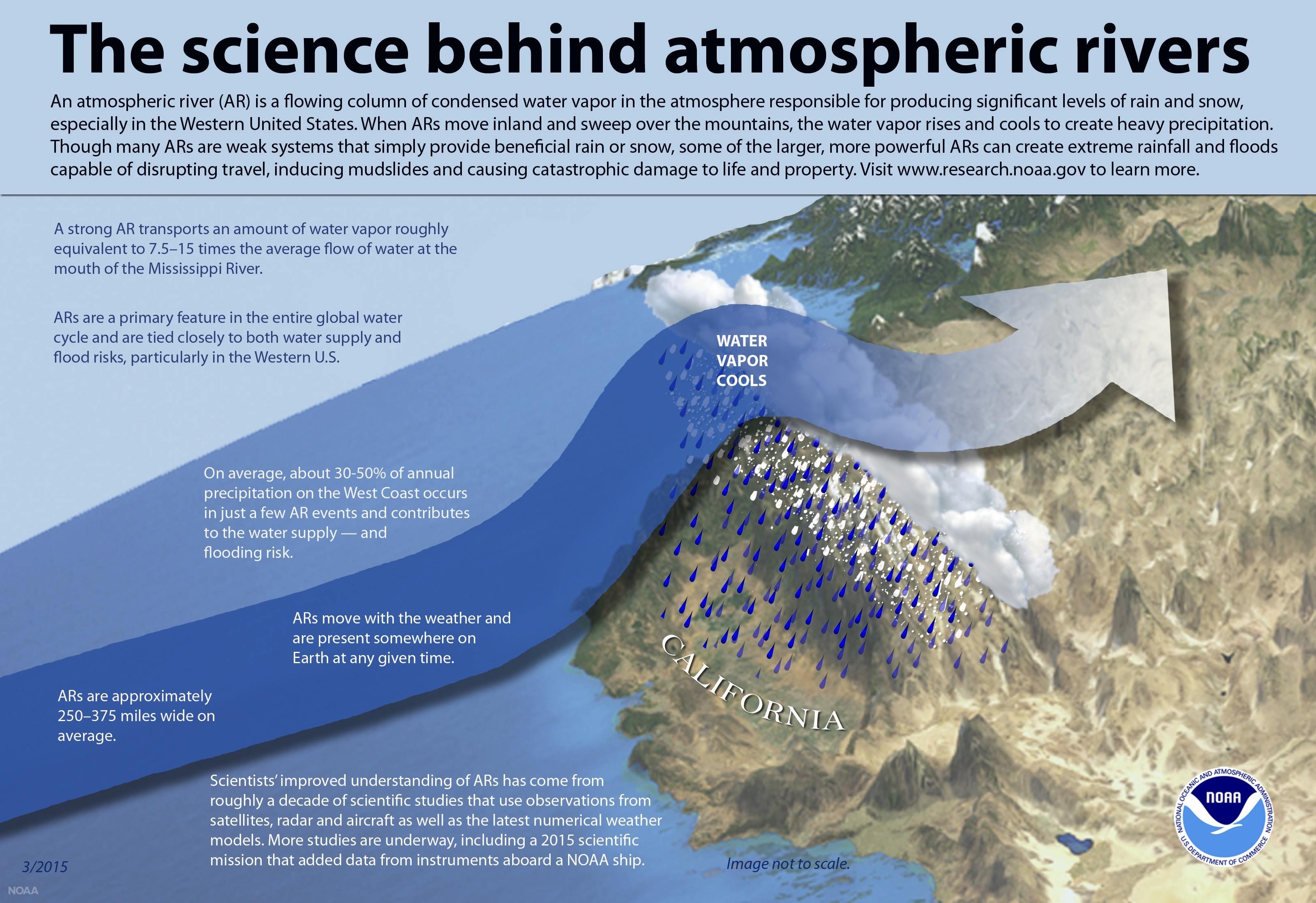
Atmospheric rivers aren’t rivers at all
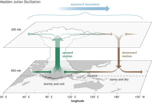
Atmospheric rivers aren’t actual waterways, but “rivers in the sky,” according to researchers. They’re intense plumes of water vapor that cause extreme precipitation, plumes so large they resemble rivers in satellite pictures. These “rivers” are responsible for more than half the rainfall in the western U.S. The Madden-Julian Oscillation is a cluster of rainstorms that moves east along the Equator over 30 to 60 days. The location of the oscillation determines where atmospheric waves will form, and their eventual impact on say, California. In previous work, the researchers have uncovered key stages of the Madden-Julian Oscillation that affect far-off weather, including atmospheric rivers. Sitting above the Madden-Julian Oscillation is a very predictable wind pattern called the quasi-biennial oscillation. Over two- to three-year periods, the winds shift east, west and back east again, and almost never deviate. This pattern directly affects the Madden-Julian Oscillation, and thus indirectly affects weather all the way to California and beyond.
The QBO matters
The CSU researchers created a model that can accurately predict atmospheric river activity in the western U.S. three weeks from now. Its inputs include the current state of the Madden-Julian Oscillation and the quasi-biennial oscillation. Using information on how atmospheric rivers have previously behaved in response to these oscillations, they found that the quasi-biennial oscillation matters – a lot. Armed with their model, the researchers want to identify and understand deficiencies in state-of-the-art numerical weather models that prevent them from predicting weather on these subseasonal time scales.
[The wind in the tropical stratosphere shifts between easterlies and westerlies over two to three years. This alternating pattern is called the QBO. Credit: NOAA Climate animation.]
“It would be worthwhile to develop a good understanding of the physical relationship between the Madden-Julian Oscillation and the quasi-biennial oscillation, and see what can be done to improve models’ simulation of this relationship,” Mundhenk said. Another logical extension of their work would be to test how well their model can forecast actual rainfall and wind or other severe weather, such as tornadoes and hail.
Edited for WeatherNation by Meteorologist Mace MichaelsAll Weather News
More
Babylon Fire in UT Surpasses 100,000 Acres, CO Fires Continue to Grow
The Aspen Acres fire continues to burn in Sou
9 Jul 2026 2:10 PM

Stormy Pattern Ahead for the Plains and Midwest
Severe weather is in the forecast across the
9 Jul 2026 12:15 PM

Saharan Dust, Excessive Heat Impact the Southeast
Hazy skies will be hovering over portions of
9 Jul 2026 11:15 AM
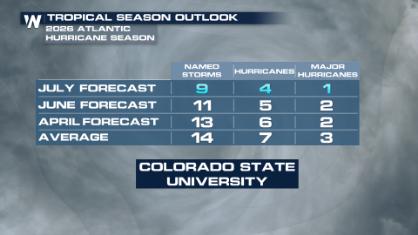
Colorado State University Scales Back 2026 Atlantic Hurricane Season Forecast
Colorado State University researchers have lo
9 Jul 2026 11:00 AM

After Flooding in the NE, Strong Storms Stick Around
NEW JERSEY - Heavy rainfall rates of around 2
8 Jul 2026 2:05 PM