End of Active Hurricane Season in Sight
Special Stories
1 Nov 2018 9:34 AM
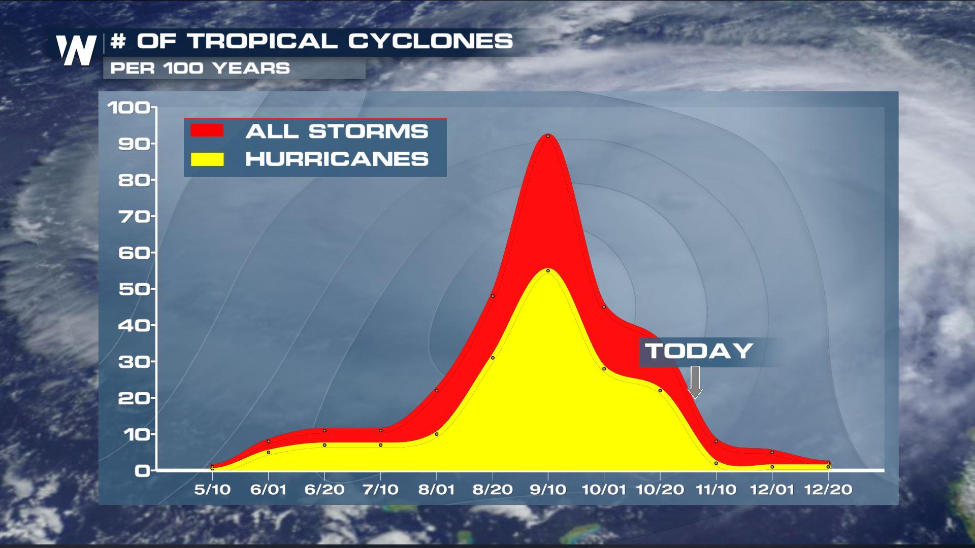
As the calendar turns to November, the final days of hurricane season are in sight. NOAA defines hurricane season from June 1 through November 30. Though storms have formed outside of those dates, this is typically the time that activity in the tropical Atlantic and Eastern Pacific begins to wind down.
So far, 2018 has been an active season, with above average activity in both basins surrounding the United States.
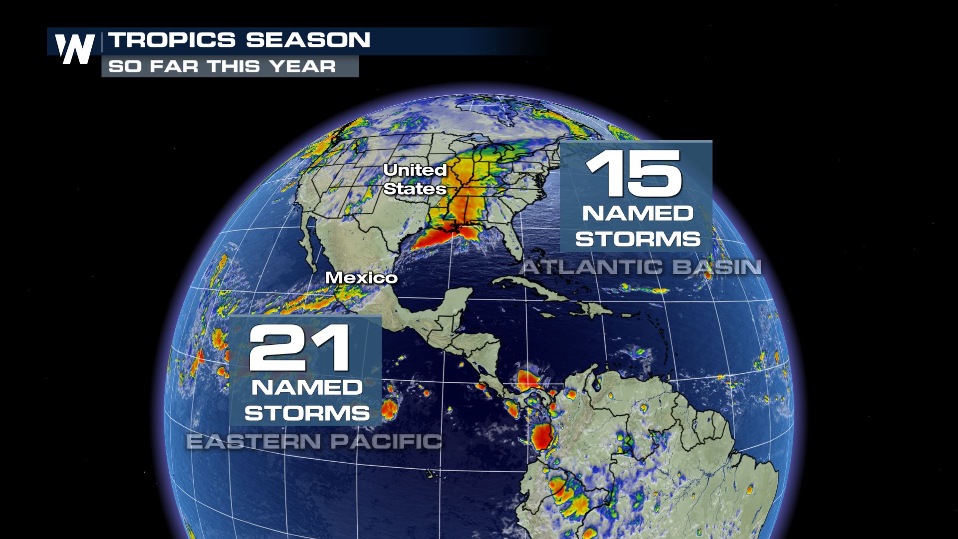
As of November 1, there have been a total of 15 named storms in the tropical Atlantic basin and 21 in the eastern Pacific.
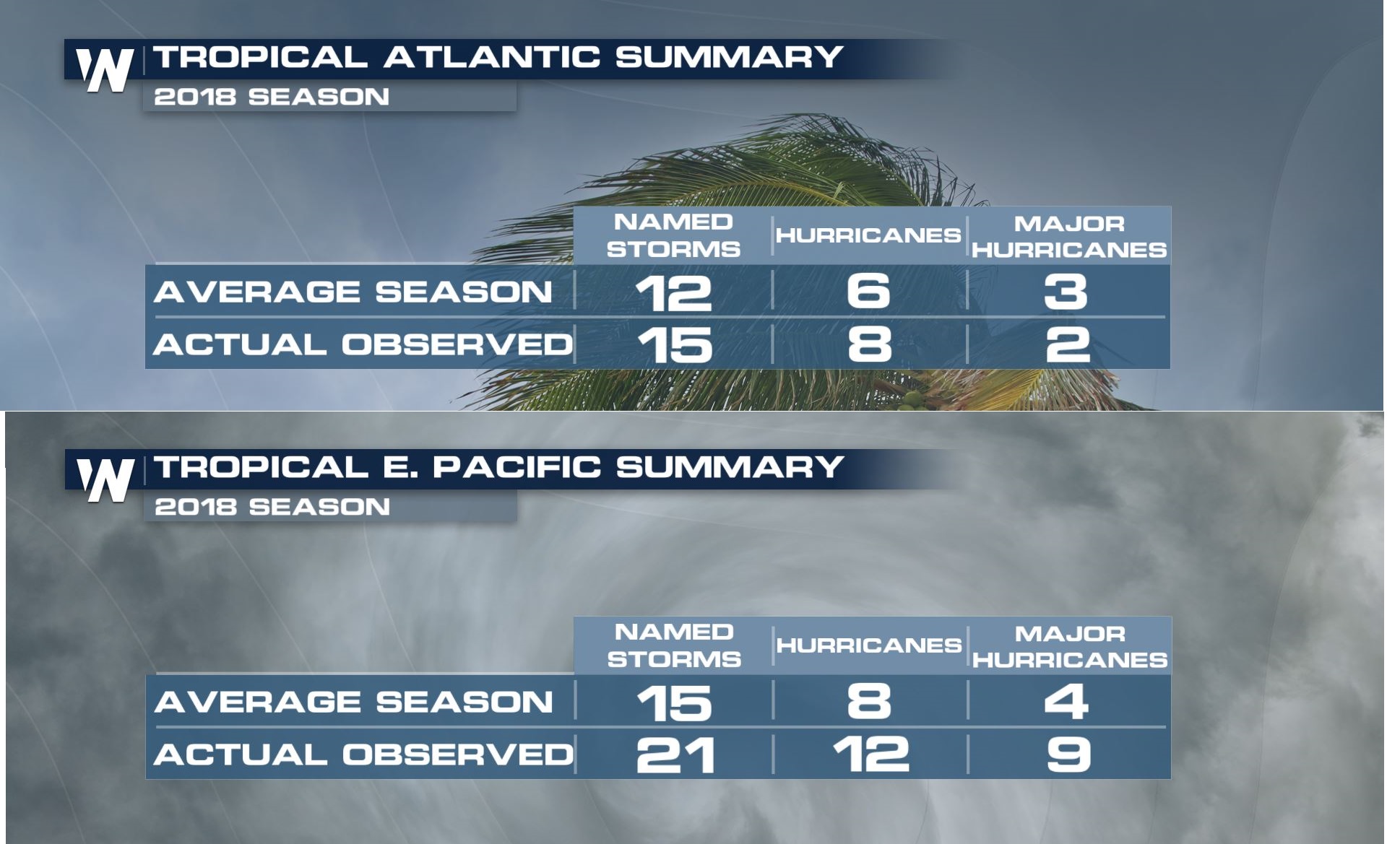
 The numbers above account for named storms, which means winds in each storm reached a threshold of tropical storm force of 39 mph or greater. When a system becomes stronger and winds reach a threshold of 74 mph or greater, it is deemed a hurricane. At 111 mph mph sustained winds or higher, a system is considered a major hurricane.
Here's how each basin breaks down into further categories. In the Eastern Pacific, there were 12 hurricanes of the 21 named storms, and 9 of those became major hurricanes. All of these numbers are considered above average.
In the Atlantic, 8 hurricanes formed of the 15 named systems, and 2 of those became major hurricanes. Florence and Michael were the 2 major hurricanes that formed in the Atlantic this season. All numbers in the Atlantic are also considered above average.
The numbers above account for named storms, which means winds in each storm reached a threshold of tropical storm force of 39 mph or greater. When a system becomes stronger and winds reach a threshold of 74 mph or greater, it is deemed a hurricane. At 111 mph mph sustained winds or higher, a system is considered a major hurricane.
Here's how each basin breaks down into further categories. In the Eastern Pacific, there were 12 hurricanes of the 21 named storms, and 9 of those became major hurricanes. All of these numbers are considered above average.
In the Atlantic, 8 hurricanes formed of the 15 named systems, and 2 of those became major hurricanes. Florence and Michael were the 2 major hurricanes that formed in the Atlantic this season. All numbers in the Atlantic are also considered above average.
 Read the National Hurricane Center season summary (released on November 1) for both the Atlantic and Eastern Pacific with specifics of each tropical cyclone.
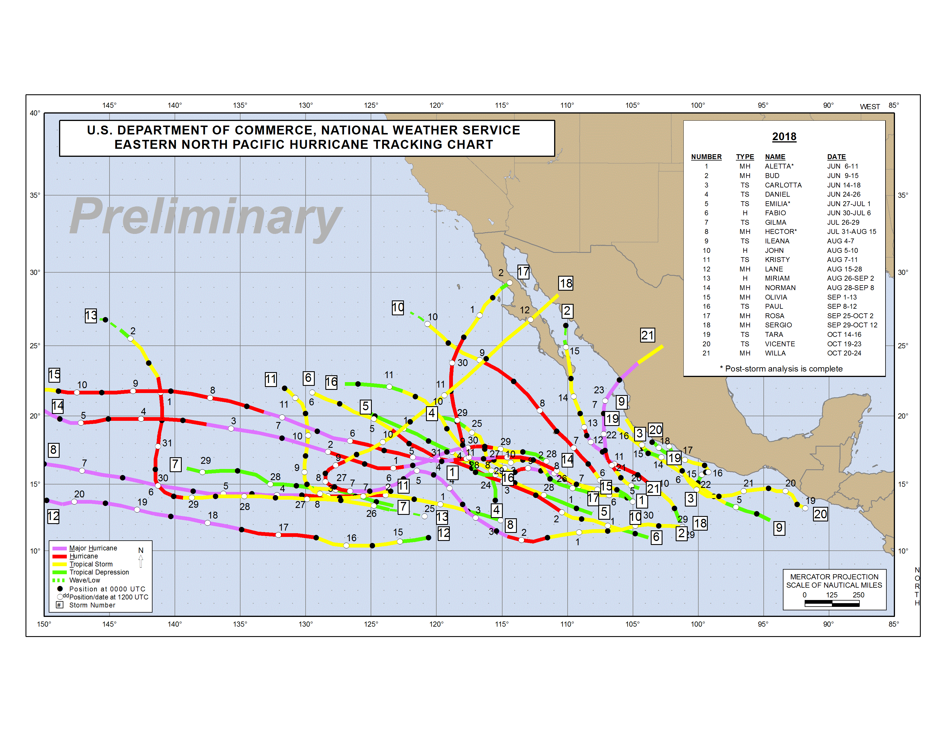 The Eastern Pacific tropical observed activity overview. Credit: US Dept. of Commerce, NWS
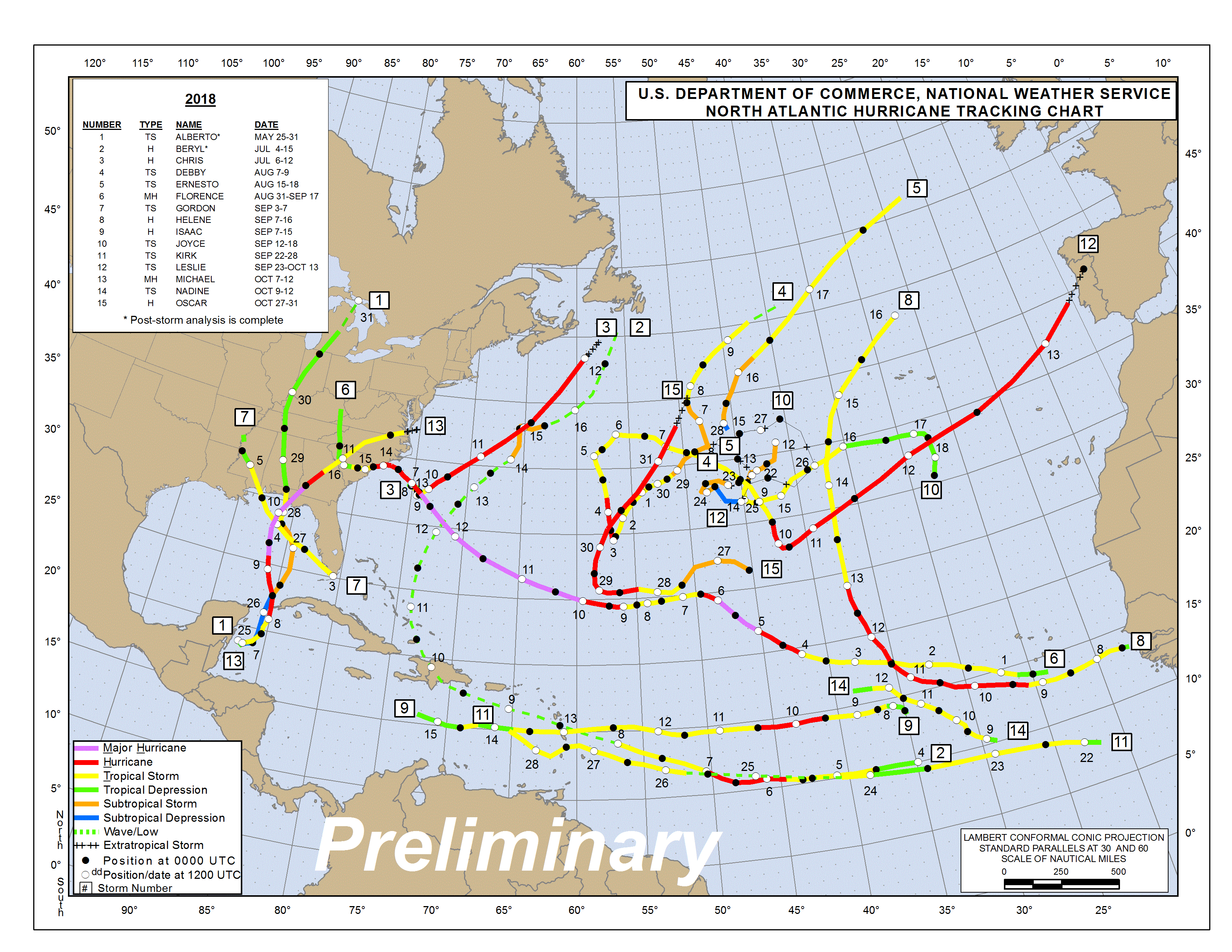 The Atlantic tropical observed activity overview. Credit: US Dept. of Commerce, NWS
The numbers above account for named storms, which means winds in each storm reached a threshold of tropical storm force of 39 mph or greater. When a system becomes stronger and winds reach a threshold of 74 mph or greater, it is deemed a hurricane. At 111 mph mph sustained winds or higher, a system is considered a major hurricane.
Here's how each basin breaks down into further categories. In the Eastern Pacific, there were 12 hurricanes of the 21 named storms, and 9 of those became major hurricanes. All of these numbers are considered above average.
In the Atlantic, 8 hurricanes formed of the 15 named systems, and 2 of those became major hurricanes. Florence and Michael were the 2 major hurricanes that formed in the Atlantic this season. All numbers in the Atlantic are also considered above average.
Read the National Hurricane Center season summary (released on November 1) for both the Atlantic and Eastern Pacific with specifics of each tropical cyclone.
The Eastern Pacific tropical observed activity overview. Credit: US Dept. of Commerce, NWS
The Atlantic tropical observed activity overview. Credit: US Dept. of Commerce, NWSAll Weather News
More
Texas Facing Major Flood Threat This week
Texas is facing a major flooding threat this
15 Jul 2026 1:45 AM

Canadian Wildfires to Send Thick Dense Smoke Across The Northern U.S.
As temperatures have soared across the Northe
15 Jul 2026 1:45 AM

Rare Enhanced Severe Threat For New England
WHAT TO EXPECT The SPC has issued a severe ou
15 Jul 2026 1:35 AM

Historic Heatwave Hits the Northern Rockies, California Heat Expands
Dangerous heat and record high temperatures c
15 Jul 2026 1:30 AM

Monsoon Moisture Returns to the Southwest, Increasing Storm and Flash Flood Potential
After weeks of hot and mostly dry weather, th
14 Jul 2026 4:15 PM

Saharan Dust and Excessive Heat Impact the Southeast
Hazy skies will be hovering over portions of
14 Jul 2026 10:05 AM

Another Day of Storms for the Plains & Front Range
Several rounds of severe weather have been ro
11 Jul 2026 1:50 AM