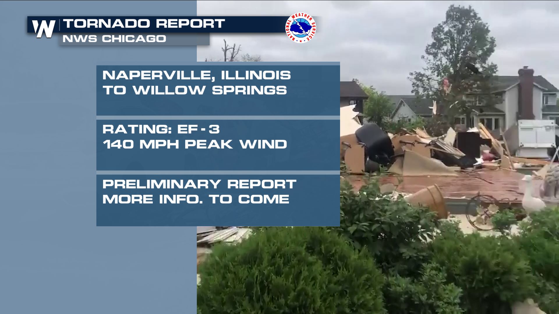
Tornado Near Chicago Rated An EF-3

Special Stories
26 Jun 2021 3:40 AM
https://twitter.com/WeatherNation/status/1406960093095104517
A powerful line of thunderstorms worked through northern Illinois Sunday night, causing widespread damage and producing a dangerous tornado. Multiple areas of rotation produced tornadic storms along the line from the Chicago suburbs, to northwest Indiana and southwest Lower Michigan.
Just after 11 pm CDT, one of the stronger cells moved through the cities of Naperville and Woodridge. As it passed through town, the National Weather Service in Chicago, IL noticed a tornado debris signature on radar, confirming a touchdown.
https://twitter.com/NWSChicago/status/1406827142642429953
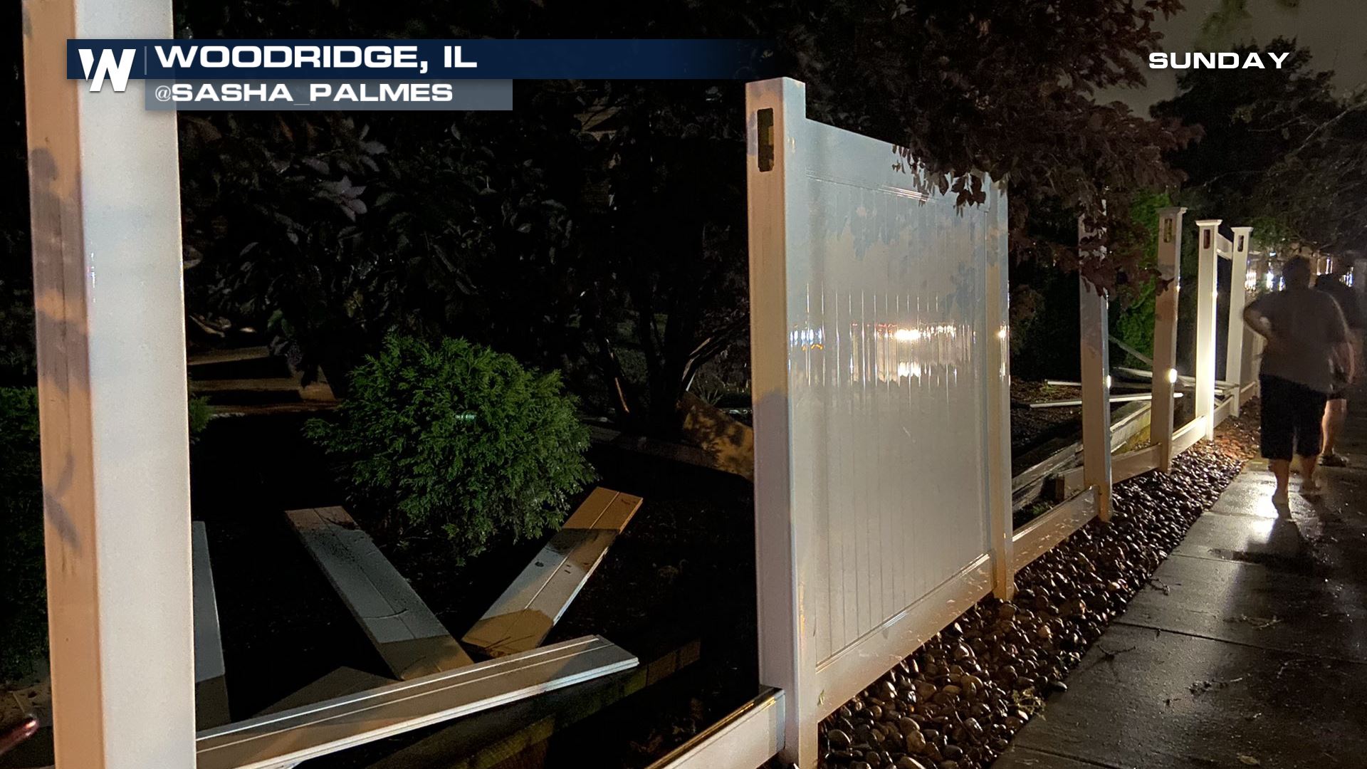 Reports of a gas leak and at least three injuries came in from Naperville, IL. Many reports of trees down in neighborhoods from Darien to Addison, IL.
The storms stayed strong as they moved through northwest Indiana. Reports of a roof collapse in South Haven, IN had officials worried about potential injuries.
The National Weather Service in Chicago has rated the Naperville tornado as an EF-3 with peak winds estimated around 140 mph.
Reports of a gas leak and at least three injuries came in from Naperville, IL. Many reports of trees down in neighborhoods from Darien to Addison, IL.
The storms stayed strong as they moved through northwest Indiana. Reports of a roof collapse in South Haven, IN had officials worried about potential injuries.
The National Weather Service in Chicago has rated the Naperville tornado as an EF-3 with peak winds estimated around 140 mph.
 This is a preliminary report, and more information is expected soon. For the latest breaking weather, stream WeatherNation 24/7.
Reports of a gas leak and at least three injuries came in from Naperville, IL. Many reports of trees down in neighborhoods from Darien to Addison, IL.
The storms stayed strong as they moved through northwest Indiana. Reports of a roof collapse in South Haven, IN had officials worried about potential injuries.
The National Weather Service in Chicago has rated the Naperville tornado as an EF-3 with peak winds estimated around 140 mph.
This is a preliminary report, and more information is expected soon. For the latest breaking weather, stream WeatherNation 24/7.All Weather News
More
Heavy Rain Returns to Texas This Weekend
It's been a week since the devastating floods
12 Jul 2025 3:10 AM

Medium Range Tropics Forecast Favors Gulf, CSU Updates Seasonal Forecast
While the Atlantic appears quiet, conditions
12 Jul 2025 3:05 AM

Elevated Tornado Risk Targets the Midwest Friday
Friday was another busy day with severe weath
12 Jul 2025 3:00 AM

Storms Return From the Front Range to Texas
Moisture is moving back into the Central and
12 Jul 2025 2:50 AM

Timeline: How Catastrophic Flooding Unfolded in Texas Hill Country
TEXAS - Catastrophic flooding devastated port
11 Jul 2025 10:00 AM

Severe Thunderstorms Expected Across the East Coast
The severe weather and flood threat continues
11 Jul 2025 2:35 AM

Ruidoso Flash Flooding - Record Crest for the Rio Ruidoso River
A slow-moving monsoonal thunderstorm develope
10 Jul 2025 1:55 AM