Flooding Continues to Worsen in the Great Lakes and Ohio Valley
Special Stories
22 Feb 2018 9:41 AM
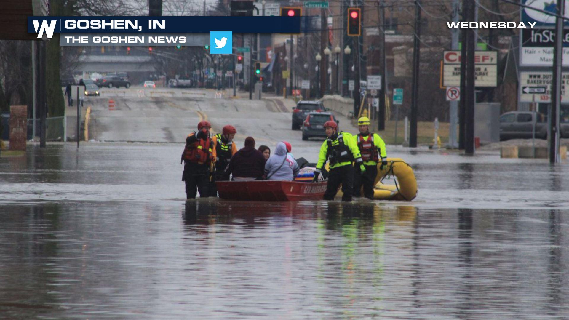
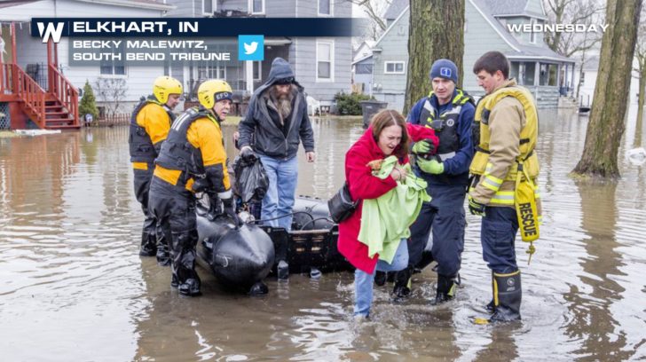
Flooding problems continue to worsen across portions of the Ohio Valley and Great Lakes. River flooding has prompted a State of Emergency in some areas of Indiana. The St. Joseph River is expected to crest at record levels around 13 feet, more than two feet above the previous record of 10.9 feet. Water rescues and evacuations have been ongoing.
 Boardwalks in Lansing, Michigan along the Grand River were submerged. 1.22 inches of rain fell, breaking a previous record of 1.04 inches, set in 1891. Even with less rain in the forecast for many flooded areas, flooding conditions are expected to worsen due to melting ice and snow.
The St. Joseph River Walk in Mishawaka, Indiana, was under water on after record-setting rain fell across Michiana, the border towns of Michigan and Indiana. South Bend had received 4.29 inches of rain since the storm system began on Monday, breaking a rainfall record set in 2014. In Mishawaka, city officials had to close access to parks and streets because of the rising St. Joseph River.
https://www.instagram.com/p/Bfb-hi3AHvq/
[Credit: Derrick Gilliam via Instagram/Storyful]
https://www.instagram.com/p/BfbilVUla-1
[Credit: Sara Rosenberg via Instagram/Storyful]
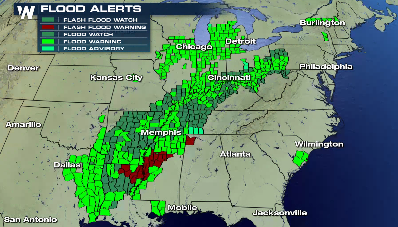
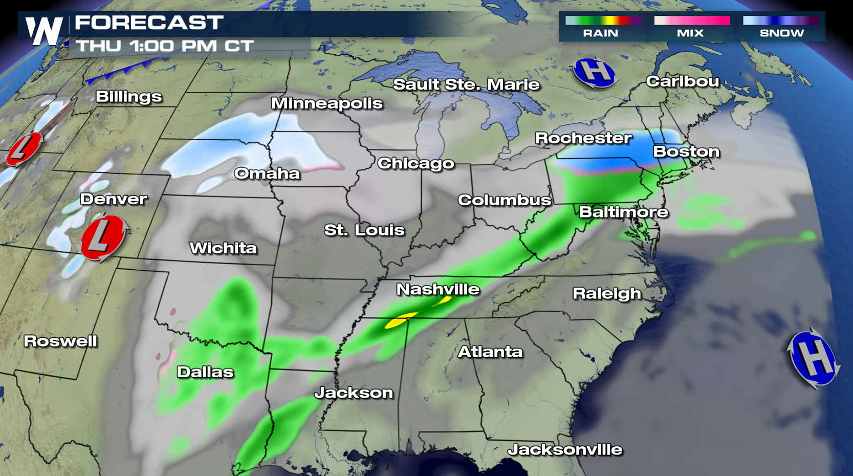
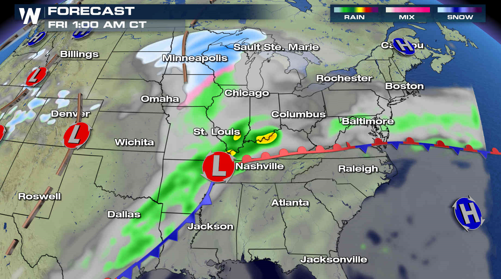
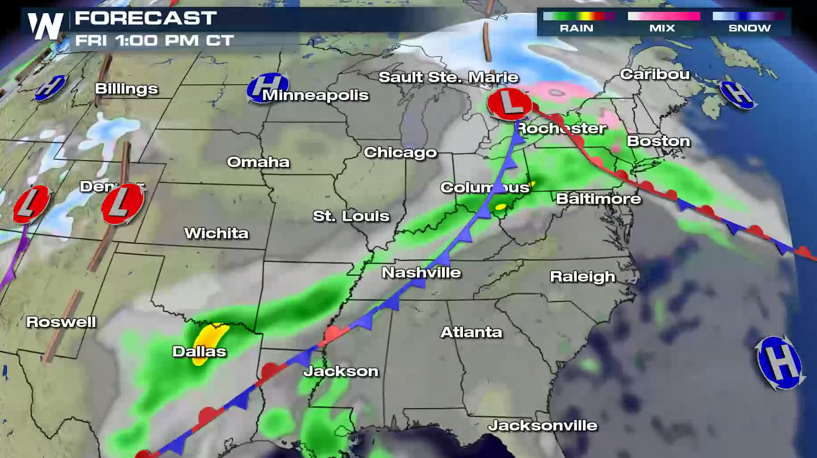
Flood alerts extend from the Northeast to the Mississippi Valley. Showers and thunderstorms will continue to produce heavy rain, with as much as 4" to 8" possible for areas along the Ohio and Mississippi Rivers.
Boardwalks in Lansing, Michigan along the Grand River were submerged. 1.22 inches of rain fell, breaking a previous record of 1.04 inches, set in 1891. Even with less rain in the forecast for many flooded areas, flooding conditions are expected to worsen due to melting ice and snow.
The St. Joseph River Walk in Mishawaka, Indiana, was under water on after record-setting rain fell across Michiana, the border towns of Michigan and Indiana. South Bend had received 4.29 inches of rain since the storm system began on Monday, breaking a rainfall record set in 2014. In Mishawaka, city officials had to close access to parks and streets because of the rising St. Joseph River.
https://www.instagram.com/p/Bfb-hi3AHvq/
[Credit: Derrick Gilliam via Instagram/Storyful]
https://www.instagram.com/p/BfbilVUla-1
[Credit: Sara Rosenberg via Instagram/Storyful]
Flood alerts extend from the Northeast to the Mississippi Valley. Showers and thunderstorms will continue to produce heavy rain, with as much as 4" to 8" possible for areas along the Ohio and Mississippi Rivers.
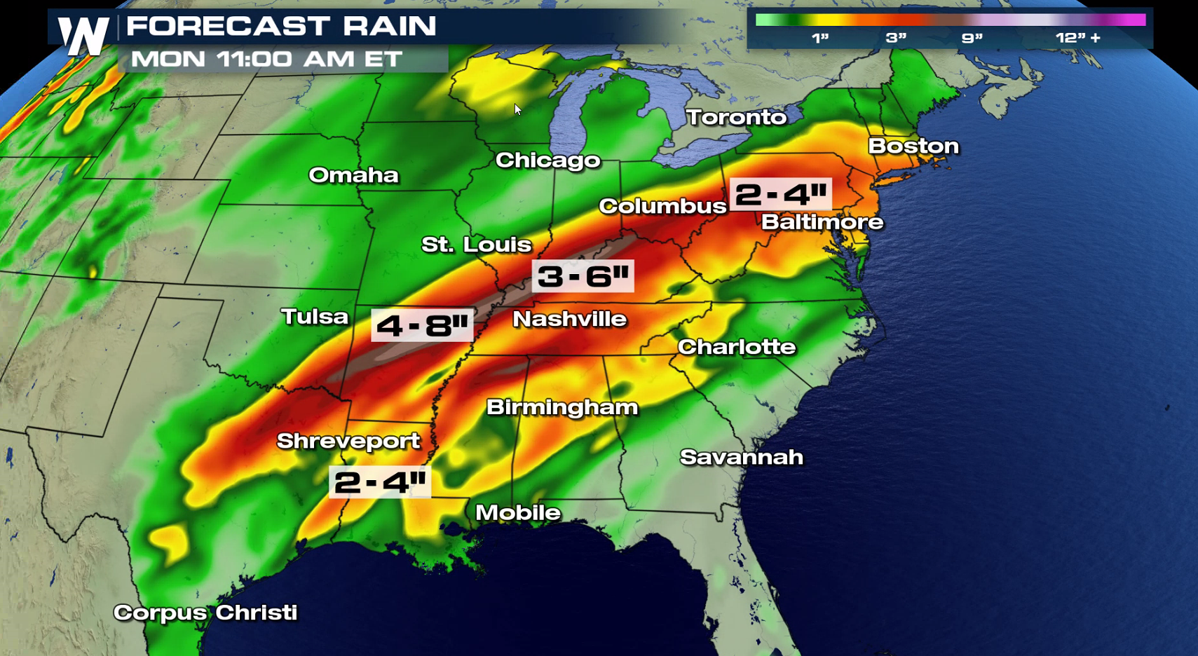 The slow moving low pressure center will aid in the development of heavy rain. Moisture levels in the atmosphere are climbing as higher humidity continues to flow into the region from the Gulf of Mexico.
 For WeatherNation: Meteorologist Mace Michaels
Boardwalks in Lansing, Michigan along the Grand River were submerged. 1.22 inches of rain fell, breaking a previous record of 1.04 inches, set in 1891. Even with less rain in the forecast for many flooded areas, flooding conditions are expected to worsen due to melting ice and snow.
The St. Joseph River Walk in Mishawaka, Indiana, was under water on after record-setting rain fell across Michiana, the border towns of Michigan and Indiana. South Bend had received 4.29 inches of rain since the storm system began on Monday, breaking a rainfall record set in 2014. In Mishawaka, city officials had to close access to parks and streets because of the rising St. Joseph River.
https://www.instagram.com/p/Bfb-hi3AHvq/
[Credit: Derrick Gilliam via Instagram/Storyful]
https://www.instagram.com/p/BfbilVUla-1
[Credit: Sara Rosenberg via Instagram/Storyful]
Flood alerts extend from the Northeast to the Mississippi Valley. Showers and thunderstorms will continue to produce heavy rain, with as much as 4" to 8" possible for areas along the Ohio and Mississippi Rivers.
The slow moving low pressure center will aid in the development of heavy rain. Moisture levels in the atmosphere are climbing as higher humidity continues to flow into the region from the Gulf of Mexico.
For WeatherNation: Meteorologist Mace MichaelsAll Weather News
More
Wildfire Outbreak in the Pacific Northwest
SPOKANE, WA - On Saturday, August 1st, the Ol
3 Aug 2026 1:55 AM

More Storms for the East Through Monday
A low-pressure system that moved through the
3 Aug 2026 1:50 AM


After Reaching Category 5, Genevieve Weakens in the Pacific
PacificGenevieve formed last Friday south of
3 Aug 2026 12:30 AM

Flooding, Severe Storms Target the Midwest Again
After an active week of storms across the nor
1 Aug 2026 1:40 AM

Flooding Risk Increases as Heavy Rain Targets the Tri-State Area
Tuesday, heavy rainfall moved across the Nort
30 Jul 2026 12:25 AM

Severe Weather: Energy From the Midwest Now in the Southeast
UPPER MIDWEST - Through Monday, dangerous tor
29 Jul 2026 10:30 PM