Flooding, Severe Weather Hits Louisiana

Special Stories
6 Jun 2019 1:28 PM
An active morning of severe weather and heavy downpours Thursday led to flooding, and numerous tornado reports in Louisiana.
As heavy, tropical rain poured in, widespread 3-6" of rain deluged the southern portion of The Pelican State. Some locations received more than 6 inches, including in Lafeyette. Rain totals as of 1pm CT Thursday had already topped 7 inches.
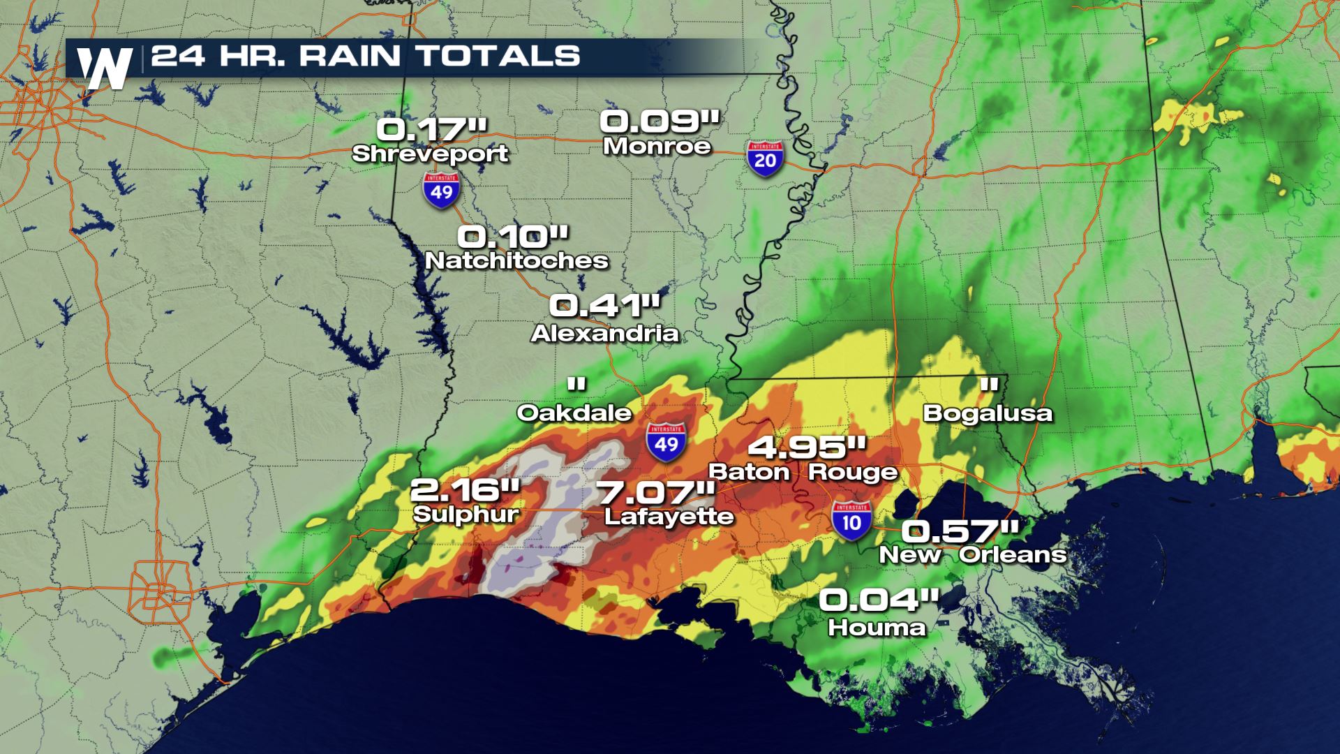 Rain led to numerous reports of flooding, including in the city of Baton Rouge. In a press conference Thursday morning, Mayor Sharon Weston Broome says at least one person was killed due to weather.
WeatherNation field correspondents were in the area, capturing visuals of cars and trucks stalled out in flood waters.
https://youtu.be/i5Gf5ssJrzo
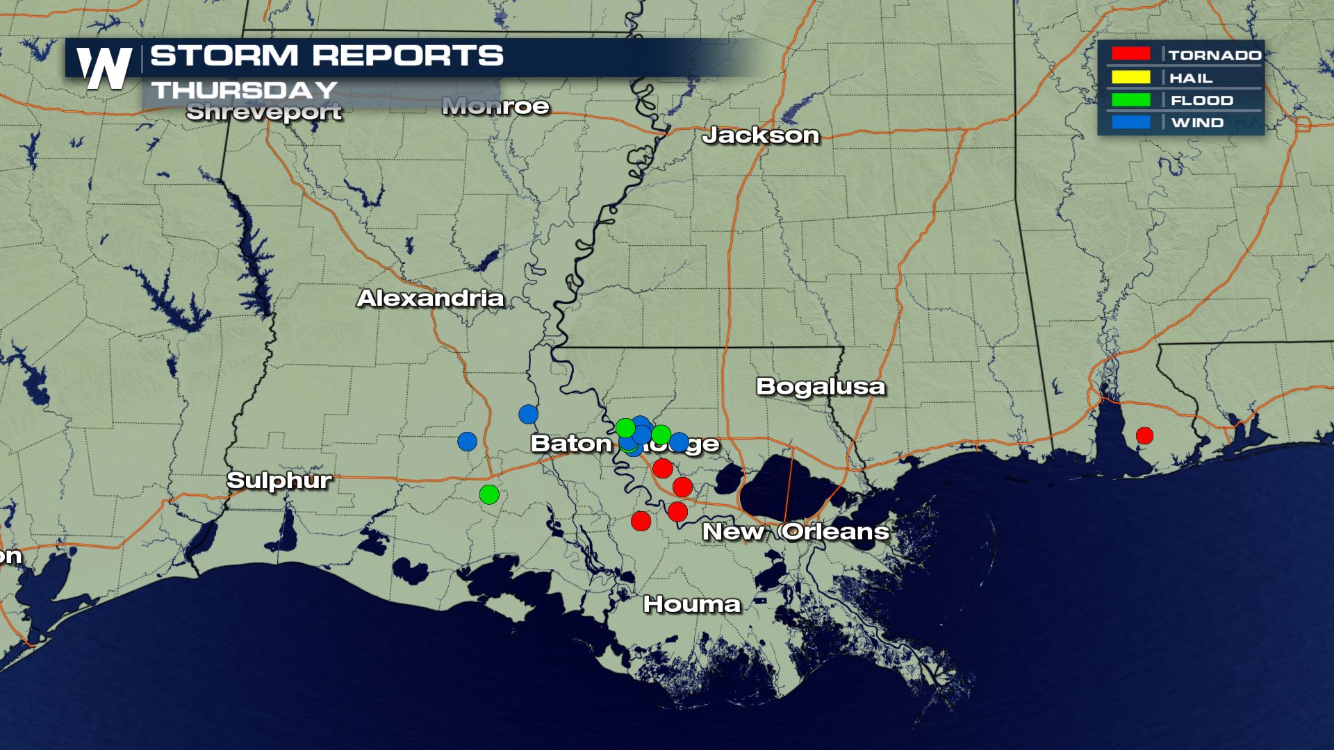
Severe thunderstorms also developed within the bands of heavy rain. These storms produced localized wind damage and tornadoes as they rolled through the state.
As of midday Thursday, at least four tornadoes were reported. Tornadoes were reported near Prairieville, Paincourtville, Sorrento, and Convent, Louisiana. The National Weather Service reports 5 people were injured in Sorrento.
One person captured the tornado crossing the road right in front of them while driving through Convent.
https://twitter.com/WeatherNation/status/1136667534046900224
Cars were tossed like toys as the storms rolled through Baton Rouge, causing damage at the local Baton Rouge General hospital
https://twitter.com/WeatherNation/status/1136715723676368897
Rain led to numerous reports of flooding, including in the city of Baton Rouge. In a press conference Thursday morning, Mayor Sharon Weston Broome says at least one person was killed due to weather.
WeatherNation field correspondents were in the area, capturing visuals of cars and trucks stalled out in flood waters.
https://youtu.be/i5Gf5ssJrzo
Severe thunderstorms also developed within the bands of heavy rain. These storms produced localized wind damage and tornadoes as they rolled through the state.
As of midday Thursday, at least four tornadoes were reported. Tornadoes were reported near Prairieville, Paincourtville, Sorrento, and Convent, Louisiana. The National Weather Service reports 5 people were injured in Sorrento.
One person captured the tornado crossing the road right in front of them while driving through Convent.
https://twitter.com/WeatherNation/status/1136667534046900224
Cars were tossed like toys as the storms rolled through Baton Rouge, causing damage at the local Baton Rouge General hospital
https://twitter.com/WeatherNation/status/1136715723676368897
 Stay with WeatherNation as we continue to follow the flooding and severe weather across the southern U.S.
Rain led to numerous reports of flooding, including in the city of Baton Rouge. In a press conference Thursday morning, Mayor Sharon Weston Broome says at least one person was killed due to weather.
WeatherNation field correspondents were in the area, capturing visuals of cars and trucks stalled out in flood waters.
https://youtu.be/i5Gf5ssJrzo
Severe thunderstorms also developed within the bands of heavy rain. These storms produced localized wind damage and tornadoes as they rolled through the state.
As of midday Thursday, at least four tornadoes were reported. Tornadoes were reported near Prairieville, Paincourtville, Sorrento, and Convent, Louisiana. The National Weather Service reports 5 people were injured in Sorrento.
One person captured the tornado crossing the road right in front of them while driving through Convent.
https://twitter.com/WeatherNation/status/1136667534046900224
Cars were tossed like toys as the storms rolled through Baton Rouge, causing damage at the local Baton Rouge General hospital
https://twitter.com/WeatherNation/status/1136715723676368897
Stay with WeatherNation as we continue to follow the flooding and severe weather across the southern U.S.All Weather News
More
Texas Hill Country: Life-Threatening Flooding
TEXAS HILL COUNTRY - Life-threatening floodin
16 Jul 2026 1:50 AM

Canadian Wildfires to Send Thick Dense Smoke Across The Northern U.S.
As temperatures have soared across the Northe
16 Jul 2026 1:40 AM

Two New Tropical Areas to Monitor in the Atlantic
Two areas of potential tropical development a
16 Jul 2026 1:10 AM

Heat Alerts Across the Nation End Thursday
ALL-TIME RECORD HIGHS were broken across the
16 Jul 2026 1:00 AM

Tucson Under Moderate Flood Risk Thursday
The monsoon has returned to the southwestern
16 Jul 2026 12:45 AM

Rare Enhanced Severe Threat For New England
WHAT TO EXPECT The SPC has issued a severe ou
15 Jul 2026 1:35 AM

Saharan Dust and Excessive Heat Impact the Southeast
Hazy skies will be hovering over portions of
14 Jul 2026 10:05 AM