Hurricane Chris Officially Forms in the Atlantic
Top Stories
10 Jul 2018 3:01 PM
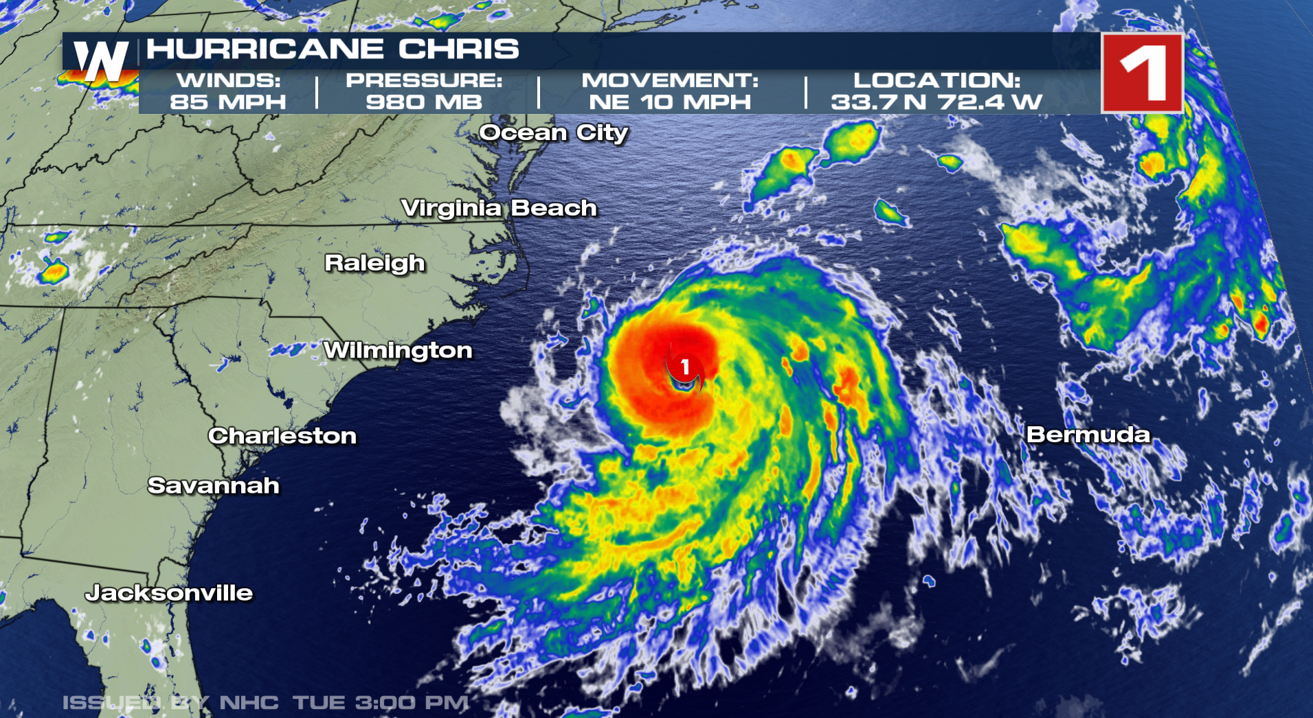
On Tuesday, Hurricane Chris officially formed in the western Atlantic, making it the second hurricane of the Atlantic season so far in 2018.
Chris officially strengthened from a tropical storm to a hurricane on Tuesday afternoon about 200 east-southeast of Cape Hatteras, North Carolina. Air Force reconnaissance aircraft found that the storm's maximum sustained winds had increased to hurricane force. Maximum winds, as of the 11pm Eastern Time advisory, were up to 105 MPH. The storm quickly strengthened to a Category 2 storm, the strongest hurricane so far in the Atlantic Basin, by late Tuesday night.
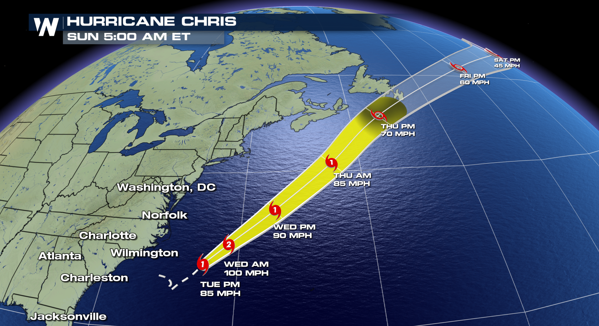
 Fortunately, Chris is not expected to pose a direct threat to the United States or the Caribbean. Large surf and rip currents will be the main hazards for the eastern seaboard of the U.S., Bermuda and the Canadian maritimes through Friday, though coastal parts of Canada could see strong winds and heavy rain from the storm.
A bit of good news with the storm as well: After remaining at or near stationary for most of Sunday and Monday, Chris' forward speed finally started to gain momentum on Tuesday, with movement up to 10 MPH by 11pm ET.
The storm will continue to accelerate off to the north and east as we move through the rest of the week.
 With Chris developing into the second hurricane of the Atlantic season, that puts the basin way ahead of schedule. The second hurricane in the Atlantic doesn't typically take place until August 28th.
Stay with WeatherNation through hurricane season and for the latest on Chris.
For WeatherNation: Meteorologist Chris Bianchi
 Fortunately, Chris is not expected to pose a direct threat to the United States or the Caribbean. Large surf and rip currents will be the main hazards for the eastern seaboard of the U.S., Bermuda and the Canadian maritimes through Friday, though coastal parts of Canada could see strong winds and heavy rain from the storm.
A bit of good news with the storm as well: After remaining at or near stationary for most of Sunday and Monday, Chris' forward speed finally started to gain momentum on Tuesday, with movement up to 10 MPH by 11pm ET.
The storm will continue to accelerate off to the north and east as we move through the rest of the week.
 With Chris developing into the second hurricane of the Atlantic season, that puts the basin way ahead of schedule. The second hurricane in the Atlantic doesn't typically take place until August 28th.
Stay with WeatherNation through hurricane season and for the latest on Chris.
For WeatherNation: Meteorologist Chris Bianchi
With Chris developing into the second hurricane of the Atlantic season, that puts the basin way ahead of schedule. The second hurricane in the Atlantic doesn't typically take place until August 28th.
Stay with WeatherNation through hurricane season and for the latest on Chris.
For WeatherNation: Meteorologist Chris BianchiAll Weather News
More