Hurricane Ian: Recovery Resources in Florida

Special Stories
5 Oct 2022 9:30 AM
Where to begin with Hurricane Ian - the 6th Category 4 or 5 hurricane to hit the U.S. Gulf Coast in 6 years, Ian's impacts were deadly and catastrophic for Southwest Florida, and will be remembered for years to come. The storm surge obliterated much of Lee County, home to Fort Myers, Ft. Myers Beach and Cape Coral. Bonita Springs saw tremendous storm surge and sadly over 70 lives have been lost as a result of the storm. Over 1600 people have been rescued by officials with over 1000 rescuers working to help. If YOU are looking to HELP - do not go to Florida UNLESS you are with an official volunteer organization. You can donate to the relief fund at Florida Disaster Fund.
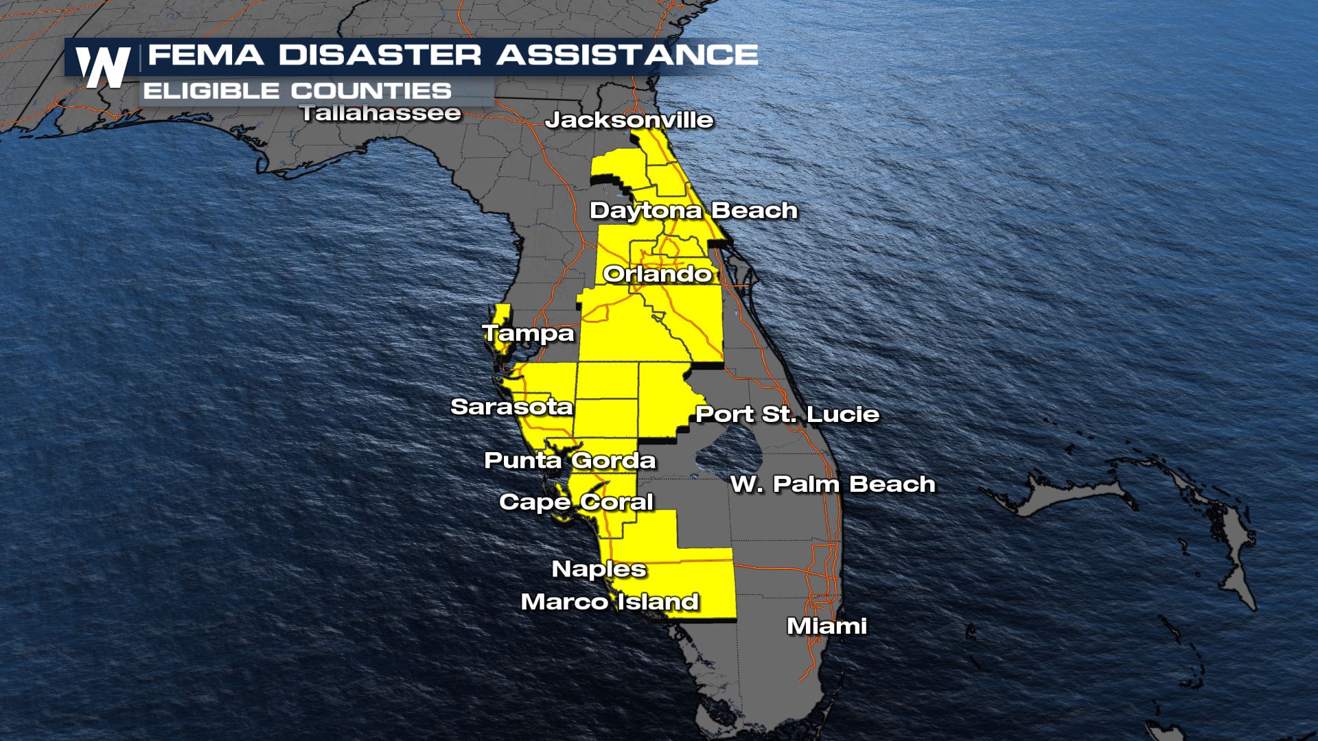
 Multiple counties in Florida have been declared disaster zones by FEMA and individuals are eligible for recovery funds. However, you must get in contact with your insurance provider before registering with FEMA.
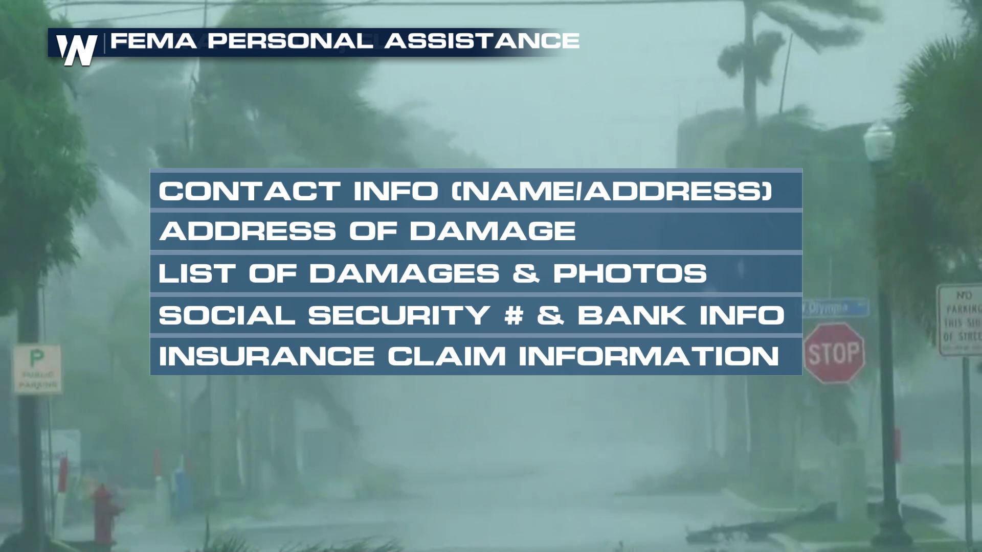
 FEMA assistance will not cover what insurance does, so it is important to know what your coverage is before you call or visit FEMA's website. Below is a list of things you will need to register.
 Landfall, of course, only looks at one part of the storm system, not the entire storm itself and the far reaching impacts. Please remember that heavy rain and flash flooding continue much beyond landfall along with storm surge. Sanibel Island was one of the hardest hit barrier islands, the only road in and out, the causeway into Sanibel was washed away.
https://twitter.com/WeatherNation/status/1575603826622619648
https://twitter.com/WeatherNation/status/1575577151021076481
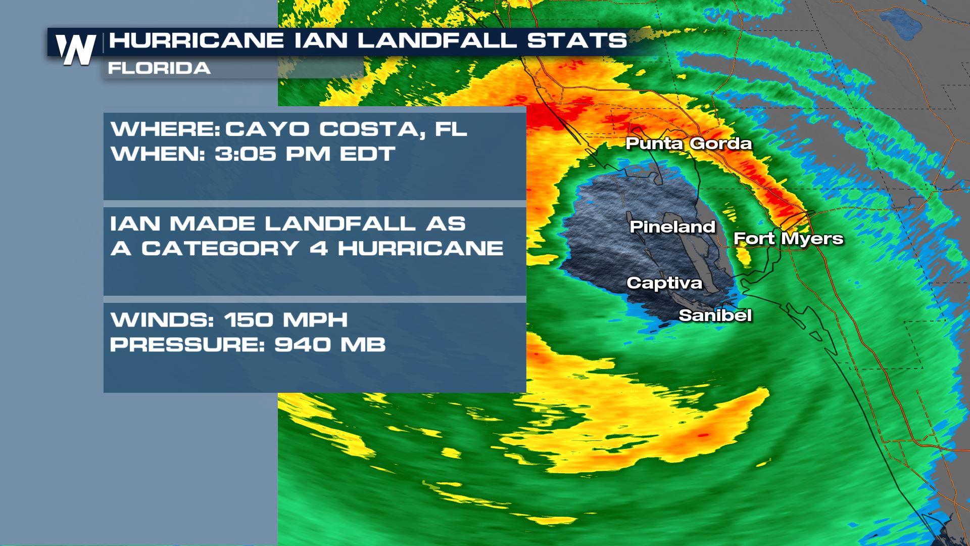
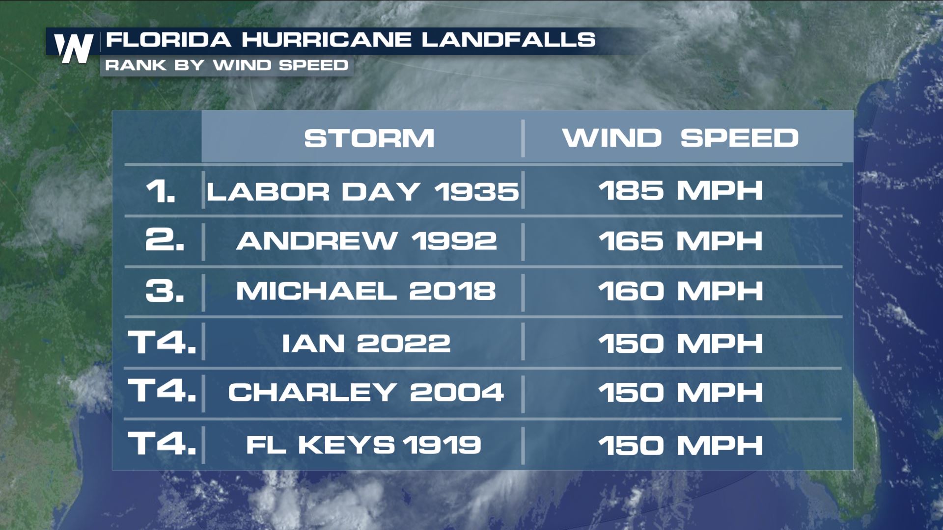
When Ian made landfall with sustained winds of 150 mph it unfortunately made the list of one of the strongest hurricanes to ever hit Florida. It is also only the 7th storm CAT 4 or 5 to hit the sunshine state since modern records began in 1950. Wind gusts were reported over 127 mph in surface stations, leading to the images of destruction seen above.
Landfall, of course, only looks at one part of the storm system, not the entire storm itself and the far reaching impacts. Please remember that heavy rain and flash flooding continue much beyond landfall along with storm surge. Sanibel Island was one of the hardest hit barrier islands, the only road in and out, the causeway into Sanibel was washed away.
https://twitter.com/WeatherNation/status/1575603826622619648
https://twitter.com/WeatherNation/status/1575577151021076481
When Ian made landfall with sustained winds of 150 mph it unfortunately made the list of one of the strongest hurricanes to ever hit Florida. It is also only the 7th storm CAT 4 or 5 to hit the sunshine state since modern records began in 1950. Wind gusts were reported over 127 mph in surface stations, leading to the images of destruction seen above.
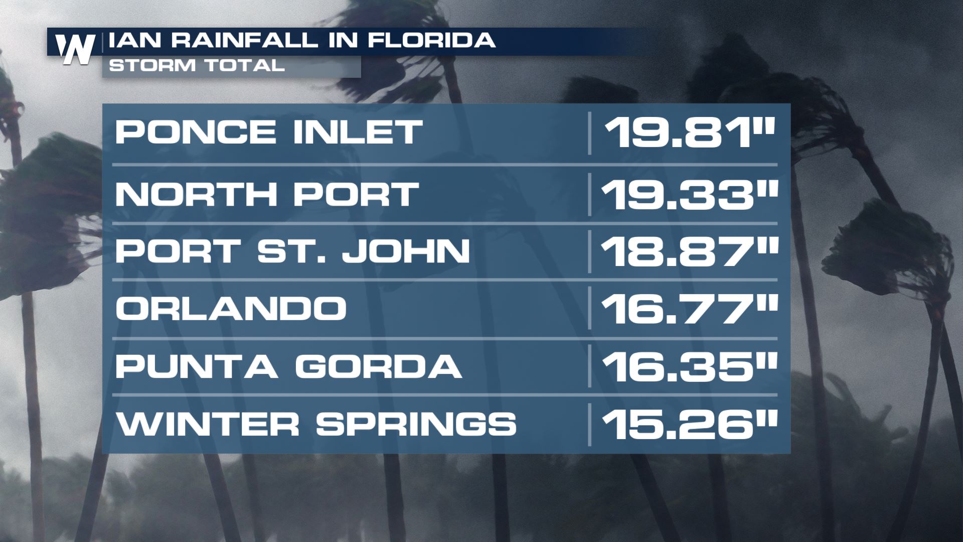
 Storm surge and rainfall completely overwhelmed rivers in Central Florida and lead to widespread flooding beyond the coast, inland to Orlando and Kissimmee. Please do not drive through flooded roadways or ignore barriers as water may still be on roadways. Rainfall totals have been on the order of nearly 20" for central Florida.
 More updates are on the way on WeatherNation. You can do that for free on any of these platforms----> How to Stream WeatherNation
Resources
The most up to date resources for the Ian disaster can be found on Florida's Disaster Recovery Page - click here. At the peak of the storm there were over 2.67 MILLION people without power across Florida - now that number is less than 500k thanks to over 40,000 line workers assisting in recovery. Still, the hardest hit counties of Lee, Charlotte and Sarasota are still without power for at least half of residents. That is leading to some communication difficulties. Florida would like you to report someone MISSING at missing.fl.gov or someone SAFE at safe.fl.gov. You will need: your contact info, their contact info, last known address and description. If you are in Florida and wondering where to start with assistance you can call the State Assistance Information Line (SAIL).
Multiple counties in Florida have been declared disaster zones by FEMA and individuals are eligible for recovery funds. However, you must get in contact with your insurance provider before registering with FEMA.
FEMA assistance will not cover what insurance does, so it is important to know what your coverage is before you call or visit FEMA's website. Below is a list of things you will need to register.
Storm Recap
Ian officially made U.S. landfall on Wednesday afternoon in Florida as a Category 4 Hurricane, becoming the 4th CAT 4 to make landfall in the sunshine state. At the time, winds were sustained at 150 mph. Damage around Sanibel island is tremendous. A second landfall in Florida followed at 4:35 PM ET and this was on mainland Florida near Pirate Harbor, a second U.S. landfall.
Landfall, of course, only looks at one part of the storm system, not the entire storm itself and the far reaching impacts. Please remember that heavy rain and flash flooding continue much beyond landfall along with storm surge. Sanibel Island was one of the hardest hit barrier islands, the only road in and out, the causeway into Sanibel was washed away.
https://twitter.com/WeatherNation/status/1575603826622619648
https://twitter.com/WeatherNation/status/1575577151021076481
When Ian made landfall with sustained winds of 150 mph it unfortunately made the list of one of the strongest hurricanes to ever hit Florida. It is also only the 7th storm CAT 4 or 5 to hit the sunshine state since modern records began in 1950. Wind gusts were reported over 127 mph in surface stations, leading to the images of destruction seen above.
Storm surge and rainfall completely overwhelmed rivers in Central Florida and lead to widespread flooding beyond the coast, inland to Orlando and Kissimmee. Please do not drive through flooded roadways or ignore barriers as water may still be on roadways. Rainfall totals have been on the order of nearly 20" for central Florida.
More updates are on the way on WeatherNation. You can do that for free on any of these platforms----> How to Stream WeatherNationAll Weather News
More
Wildfire Outbreak in the Pacific Northwest
SPOKANE, WA - On Saturday, August 1st, the Ol
2 Aug 2026 7:20 PM

More Storms for the East Through Monday
A low-pressure system that moved through the
2 Aug 2026 7:20 PM


After Reaching Category 5, Genevieve Weakens in the Pacific
PacificGenevieve formed on last Friday south
2 Aug 2026 6:25 PM

Flooding, Severe Storms Target the Midwest Again
After an active week of storms across the nor
1 Aug 2026 1:40 AM

Flooding Risk Increases as Heavy Rain Targets the Tri-State Area
Tuesday, heavy rainfall moved across the Nort
30 Jul 2026 12:25 AM

Severe Weather: Energy From the Midwest Now in the Southeast
UPPER MIDWEST - Through Monday, dangerous tor
29 Jul 2026 10:30 PM