Isaac Now a Hurricane; May Impact Lesser Antilles Later This Week
Special Stories
10 Sep 2018 8:45 AM
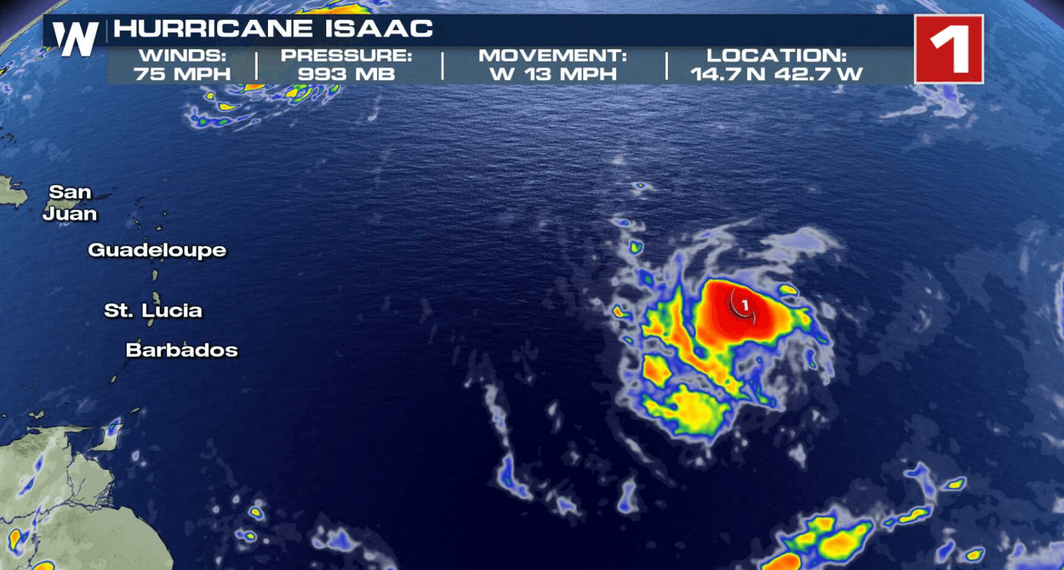
Late Sunday night, Isaac became the 5th hurricane this season in the Atlantic Basin. The storm is located around 1200 miles east of the Windward Islands. Wind speeds have stayed steady around 75 mph this morning, similar to Sunday night.
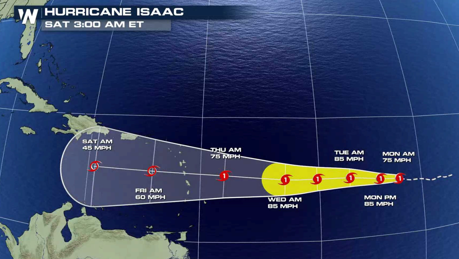 The forecast keeps the storm moving westward with a slight increase in intensity. The National Hurricane Center noted Sunday night that "the dynamical track model spread is nearly 1000 miles at day 5, while the intensity guidance spread is nearly 100 knots", leading to uncertainties in the longer term forecast.
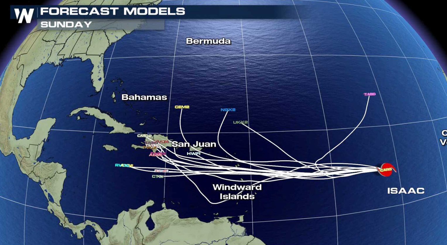
Several weather forecast models show a curve to the north in a few days as a trough of low pressure pulls the system up in latitude before reaching the Lesser Antilles. Other models maintain a stronger upper level ridge to the north of Issac, keeping the cyclone on a westward path. The National Hurricane Center forecast maintains a westward movement through the end of the week.
The forecast keeps the storm moving westward with a slight increase in intensity. The National Hurricane Center noted Sunday night that "the dynamical track model spread is nearly 1000 miles at day 5, while the intensity guidance spread is nearly 100 knots", leading to uncertainties in the longer term forecast.
Several weather forecast models show a curve to the north in a few days as a trough of low pressure pulls the system up in latitude before reaching the Lesser Antilles. Other models maintain a stronger upper level ridge to the north of Issac, keeping the cyclone on a westward path. The National Hurricane Center forecast maintains a westward movement through the end of the week.
 Isaac is a very compact storm, with hurricane force winds only extending 10 miles from the center. Tropical storm force winds push out only 45 miles from the core. The National Hurricane Center notes that "small hurricanes like this one are more prone to quick intensity changes, both up and down." The models are in poor agreement, ranging from a tropical storm to major hurricane later this week. Wind shear is expected to be light until the end of the week, so some strengthening is expected. WeatherNation will keep you updated on-air and online with the latest information on Hurricane Isaac.
For WeatherNation: Meteorologist Mace Michaels
Isaac is a very compact storm, with hurricane force winds only extending 10 miles from the center. Tropical storm force winds push out only 45 miles from the core. The National Hurricane Center notes that "small hurricanes like this one are more prone to quick intensity changes, both up and down." The models are in poor agreement, ranging from a tropical storm to major hurricane later this week. Wind shear is expected to be light until the end of the week, so some strengthening is expected. WeatherNation will keep you updated on-air and online with the latest information on Hurricane Isaac.
For WeatherNation: Meteorologist Mace Michaels
The forecast keeps the storm moving westward with a slight increase in intensity. The National Hurricane Center noted Sunday night that "the dynamical track model spread is nearly 1000 miles at day 5, while the intensity guidance spread is nearly 100 knots", leading to uncertainties in the longer term forecast.
Several weather forecast models show a curve to the north in a few days as a trough of low pressure pulls the system up in latitude before reaching the Lesser Antilles. Other models maintain a stronger upper level ridge to the north of Issac, keeping the cyclone on a westward path. The National Hurricane Center forecast maintains a westward movement through the end of the week.
Isaac is a very compact storm, with hurricane force winds only extending 10 miles from the center. Tropical storm force winds push out only 45 miles from the core. The National Hurricane Center notes that "small hurricanes like this one are more prone to quick intensity changes, both up and down." The models are in poor agreement, ranging from a tropical storm to major hurricane later this week. Wind shear is expected to be light until the end of the week, so some strengthening is expected. WeatherNation will keep you updated on-air and online with the latest information on Hurricane Isaac.
For WeatherNation: Meteorologist Mace MichaelsAll Weather News
More
Very Hot Temperatures For the Western and Central United States
Are you over the summer heat yet? Well, more
23 Jul 2026 10:50 PM

Tropics: Bertha Dissipates, Fausto Heads to Hawaii
BerthaBertha has now moved inland into easter
23 Jul 2026 10:20 PM

Flash Flooding for the Carolinas This Week
A stalled boundary over the Carolinas will ke
23 Jul 2026 7:45 PM

Hot & Smoky w/ a Chance of Lightning
Conditions have been really dry out west. We'
23 Jul 2026 1:20 PM

Another Round of Storms Targets the Northeast
Tuesday brought severe weather again across p
23 Jul 2026 1:15 AM

Another Round of Severe Weather for the Upper Midwest and Great Lakes
The upper-level low train continues to keep t
21 Jul 2026 1:45 AM

Air Quality Improvements in the Forecast
Wildfires burning in Northwestern Ontario, Ca
20 Jul 2026 7:20 PM