June Forecast from NOAA's Climate Prediction Center
Special Stories
18 May 2018 10:14 AM
On Thursday, NOAA's Climate Prediction Center (CPC) issued their one month outlook for June. After a cold beginning to spring, the start of summer looks warmer over most of the nation. Above average temperatures are in the forecast over almost all of the nation, excluding Florida and the Great Lakes. The Southwest has the the highest percentages to see warmer than normal weather. Wetter than average weather is expected in the Southeast, with below normal precipitation in the Northwest.
https://twitter.com/NWSCPC/status/997096116024786944
The CPC states that the "forecast was based on dynamical model guidance, statistical tools, current soil moisture conditions, and potential influences from modes of tropical variability." La Nina is no longer an influence, as water temperatures in the Pacific Ocean have returned to near average.
Soil moisture is very low across the Southwest and central and southern Plains, which influenced the higher likelihood of warmer than normal weather. With soil moisture content high around the Great Lakes, temperatures are expected to be closer to average for June.
The position of the Madden-Julian Oscillation (MJO) thunderstorms in the Pacific Ocean, located near the Equator, are being observed as well. Their behavior and location has been shown to have a link to tropical development and rainfall totals. This is the main reason why above average precipitation is in the forecast for the Southeast. The June forecast will be updated at the end of this month.
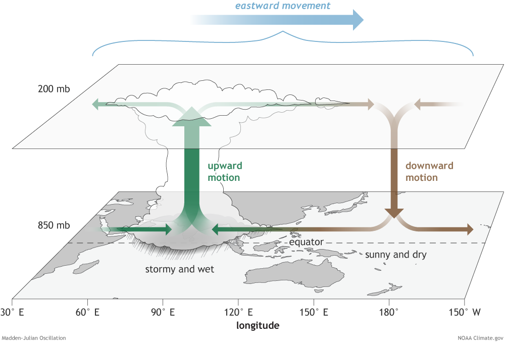 [The surface and upper-atmosphere structure of the MJO for a period when the enhanced convective phase (thunderstorm cloud) is centered across the Indian Ocean and the suppressed convective phase is centered over the west-central Pacific Ocean. Horizontal arrows pointing left represent wind departures from average that are easterly, and arrows pointing right represent wind departures from average that are westerly. The entire system shifts eastward over time, eventually circling the globe and returning to its point of origin. NOAA drawing by Fiona Martin.]
For WeatherNation: Meteorologist Mace Michaels
[The surface and upper-atmosphere structure of the MJO for a period when the enhanced convective phase (thunderstorm cloud) is centered across the Indian Ocean and the suppressed convective phase is centered over the west-central Pacific Ocean. Horizontal arrows pointing left represent wind departures from average that are easterly, and arrows pointing right represent wind departures from average that are westerly. The entire system shifts eastward over time, eventually circling the globe and returning to its point of origin. NOAA drawing by Fiona Martin.]
For WeatherNation: Meteorologist Mace MichaelsAll Weather News
More
East Gears Up for Stormy, Wet Weekend
A low pressure system crashing through the Mi
1 Aug 2026 11:35 AM


Flooding, Severe Storms Target the Midwest Again
After an active week of storms across the nor
1 Aug 2026 1:40 AM


After Reaching Category 5, Genevieve Weakens in the Pacific
PacificFausto is now a post-tropical cyclone.
31 Jul 2026 1:30 AM

Flooding Risk Increases as Heavy Rain Targets the Tri-State Area
Tuesday, heavy rainfall moved across the Nort
30 Jul 2026 12:25 AM

Severe Weather: Energy From the Midwest Now in the Southeast
UPPER MIDWEST - Through Monday, dangerous tor
29 Jul 2026 10:30 PM