Landsat 8 Marks Five Years in Orbit
Special Stories
13 Feb 2018 9:35 AM
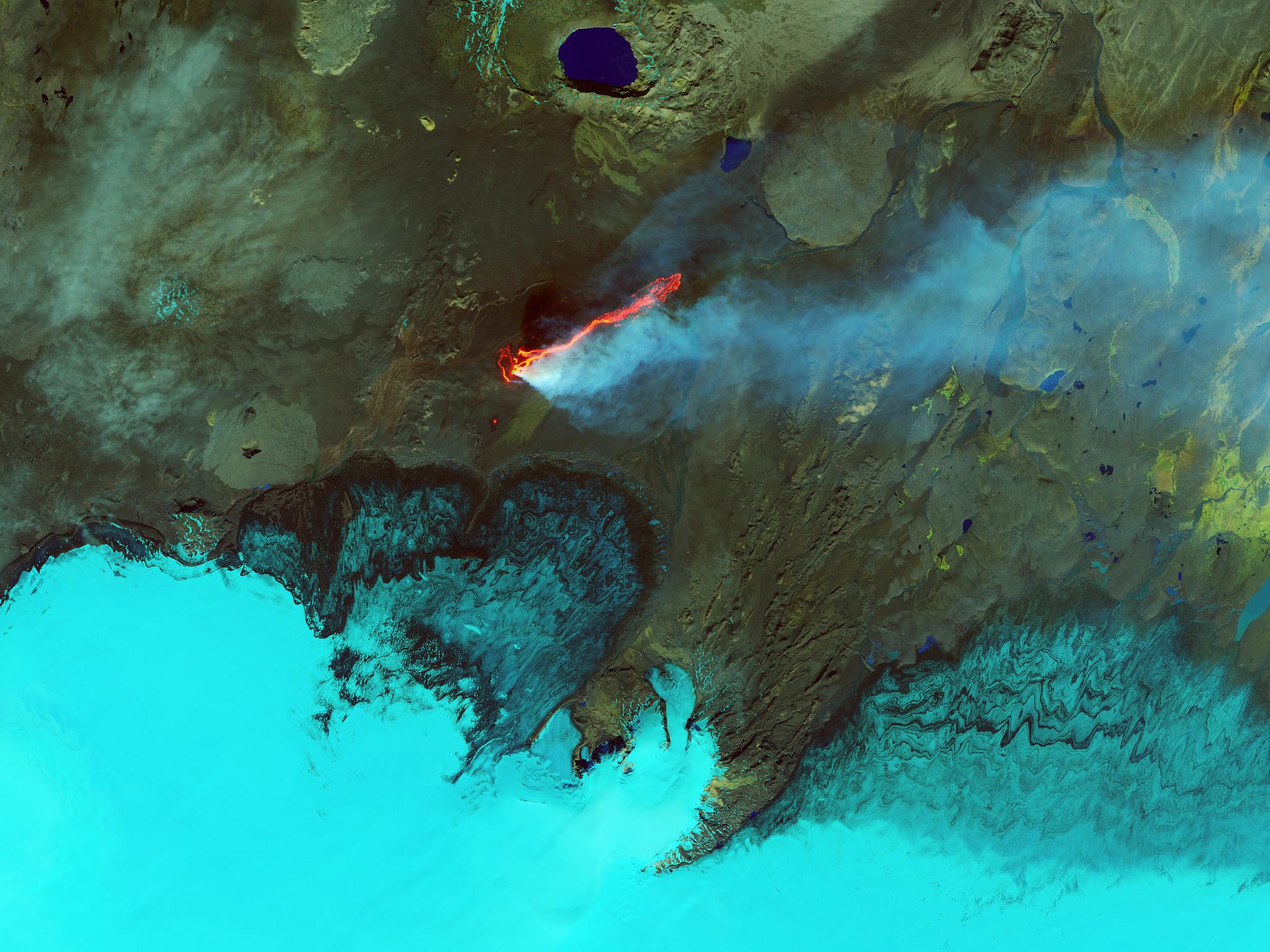
[Roiling Flows on Holuhraun Lava Field, Iceland. From NASA]
From NASA
In its five years in space, the Landsat 8 Earth-observing satellite has racked up some impressive statistics: 26,500 orbits around the planet, 1.1 million "scenes" captured, a motherlode of images that represents 16 percent of all the observations in the 45-year Landsat archive.
But more impressive and important than any set of numbers, Landsat 8 – which makes global measurements of Earth's land surface – strengthened the program's role as a cornerstone among the growing number of government and commercial programs that capture imagery of Earth from space.
Landsat 8's global coverage and faster data acquisition rates are enabling significant research and opening up new ways in which scientists, businesses, and resource managers can use the data – including water quality mapping, near-real-time ice velocity detection, and improved tracking of crop health and how much water crops use.
https://www.youtube.com/watch?v=bmoYMzGBN5s
"I am thrilled by the performance of Landsat 8," said NASA Landsat 8 Project Scientist Jim Irons. “And even more so by the adoption of the data by so many people for important, consequential research and applications.”
The Landsat program is a collaboration between NASA and the U.S. Geological Survey. NASA oversees the design, build, and launch; USGS takes over operations once satellites are in orbit, and manages the expanding data archive. Landsat 8 is the latest success in this nearly 50-year partnership.
"If we look back over the five years, have we hit our mark?" said Tom Loveland, Chief Scientist at USGS' Earth Resources and Observation Science (EROS) center. "My answer would be that to date, almost all capabilities that we rely on for Landsat 8 are working superbly."
 [This gif shows the Landsat Data Continuity Mission (LDCM) spacecraft successfully separating from the booster. Credits: NASA]
Landsat 8, which before launch was called the Landsat Data Continuity Mission, launched into orbit on Feb. 11, 2013. Once it became operational and was renamed Landsat 8, the satellite continued a streak of engineering and science success unmatched in spaceflight: the succession of Landsat satellites has now made 45-plus years of continuous observations of Earth's surface, without any gaps.
The length of this record is what makes Landsat a "cornerstone" program in the growing field of land imaging. For scientists that want to compare new imagery or data to previous decades, the unbroken Landsat record offers the one, consistent reference point. This role is furthered by USGS’s and NASA's commitment to keeping the entire Landsat data archive free and accessible to scientists and the public. Landsat 9 is targeting a launch in 2020 and will continue that role.
At a time when more commercial imagers are operating, "Landsat 9 will launch into this mix and continue to provide the stability and reliability necessary to systematically study Earth surface dynamics,” Irons said.
[This gif shows the Landsat Data Continuity Mission (LDCM) spacecraft successfully separating from the booster. Credits: NASA]
Landsat 8, which before launch was called the Landsat Data Continuity Mission, launched into orbit on Feb. 11, 2013. Once it became operational and was renamed Landsat 8, the satellite continued a streak of engineering and science success unmatched in spaceflight: the succession of Landsat satellites has now made 45-plus years of continuous observations of Earth's surface, without any gaps.
The length of this record is what makes Landsat a "cornerstone" program in the growing field of land imaging. For scientists that want to compare new imagery or data to previous decades, the unbroken Landsat record offers the one, consistent reference point. This role is furthered by USGS’s and NASA's commitment to keeping the entire Landsat data archive free and accessible to scientists and the public. Landsat 9 is targeting a launch in 2020 and will continue that role.
At a time when more commercial imagers are operating, "Landsat 9 will launch into this mix and continue to provide the stability and reliability necessary to systematically study Earth surface dynamics,” Irons said.
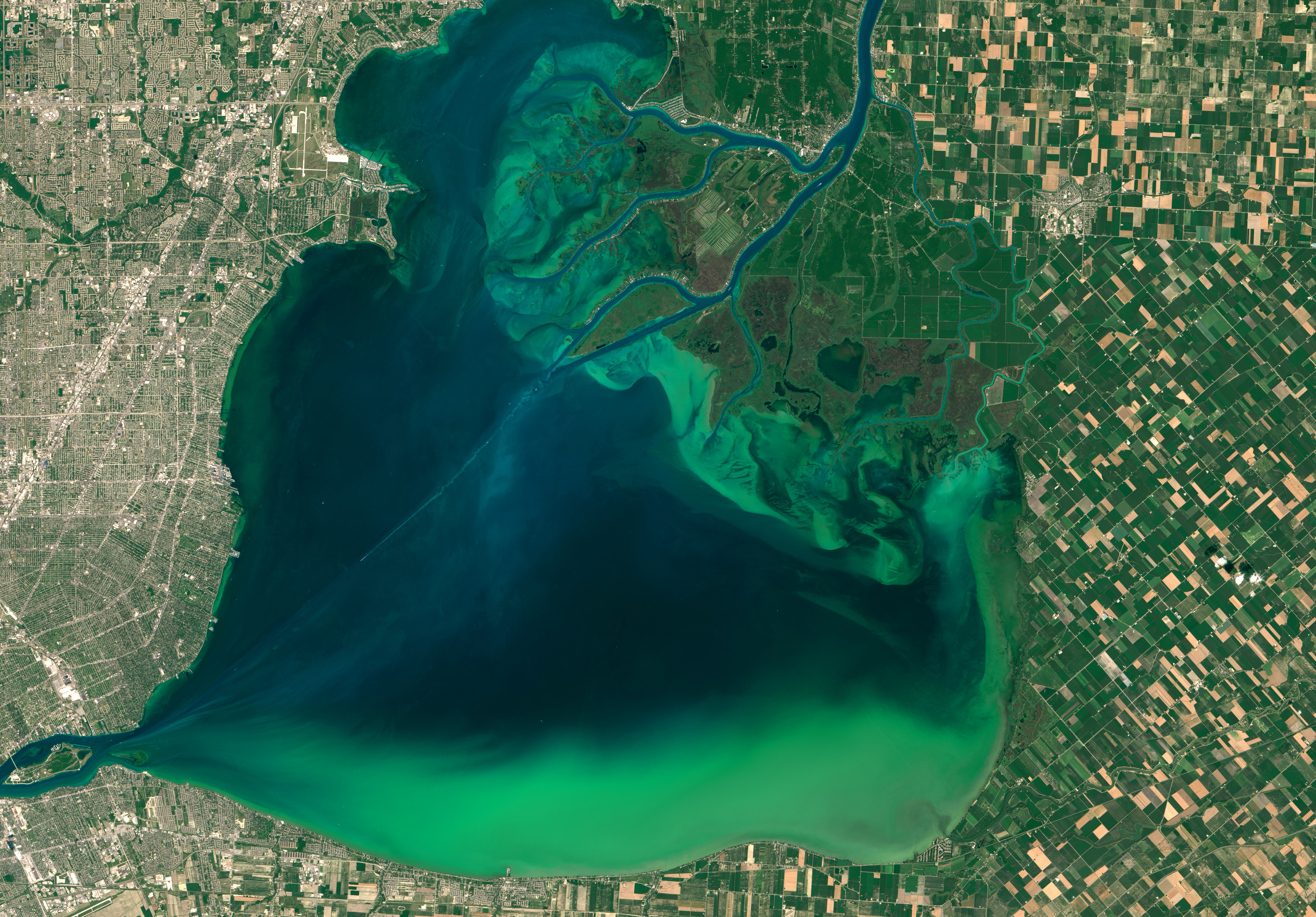 [Image On July 28, 2015, the Operational Land Imager (OLI) on Landsat 8 captured these images of algal blooms around the Great Lakes. The bloom is visible as swirls of green in Lake St. Clair. Credit: NASA Earth Observatory]
Landsat 8 benefits from evolutionary technological advances over its predecessors. Landsat 8’s Operational Land Imager (OLI) collects data in two new spectral bands: a deep blue (coastal/aerosol) band and a cirrus cloud detection band. Both of Landsat 8’s science instruments, OLI and the Thermal Infrared Sensor (TIRS), can outperform their predecessors’ measurement sensitivity due to an improved signal-to-noise ratio (SNR).
These improvements have been integral to the work of water quality managers who can now use Landsat 8 to map water quality indicators in coastal and inland waters.
"We can now pull out detailed maps of water constituents, including chlorophyll, dissolved organic matter, and suspended sediment," says Jeff Masek, the Landsat 9 Project Scientist.
[Image On July 28, 2015, the Operational Land Imager (OLI) on Landsat 8 captured these images of algal blooms around the Great Lakes. The bloom is visible as swirls of green in Lake St. Clair. Credit: NASA Earth Observatory]
Landsat 8 benefits from evolutionary technological advances over its predecessors. Landsat 8’s Operational Land Imager (OLI) collects data in two new spectral bands: a deep blue (coastal/aerosol) band and a cirrus cloud detection band. Both of Landsat 8’s science instruments, OLI and the Thermal Infrared Sensor (TIRS), can outperform their predecessors’ measurement sensitivity due to an improved signal-to-noise ratio (SNR).
These improvements have been integral to the work of water quality managers who can now use Landsat 8 to map water quality indicators in coastal and inland waters.
"We can now pull out detailed maps of water constituents, including chlorophyll, dissolved organic matter, and suspended sediment," says Jeff Masek, the Landsat 9 Project Scientist.
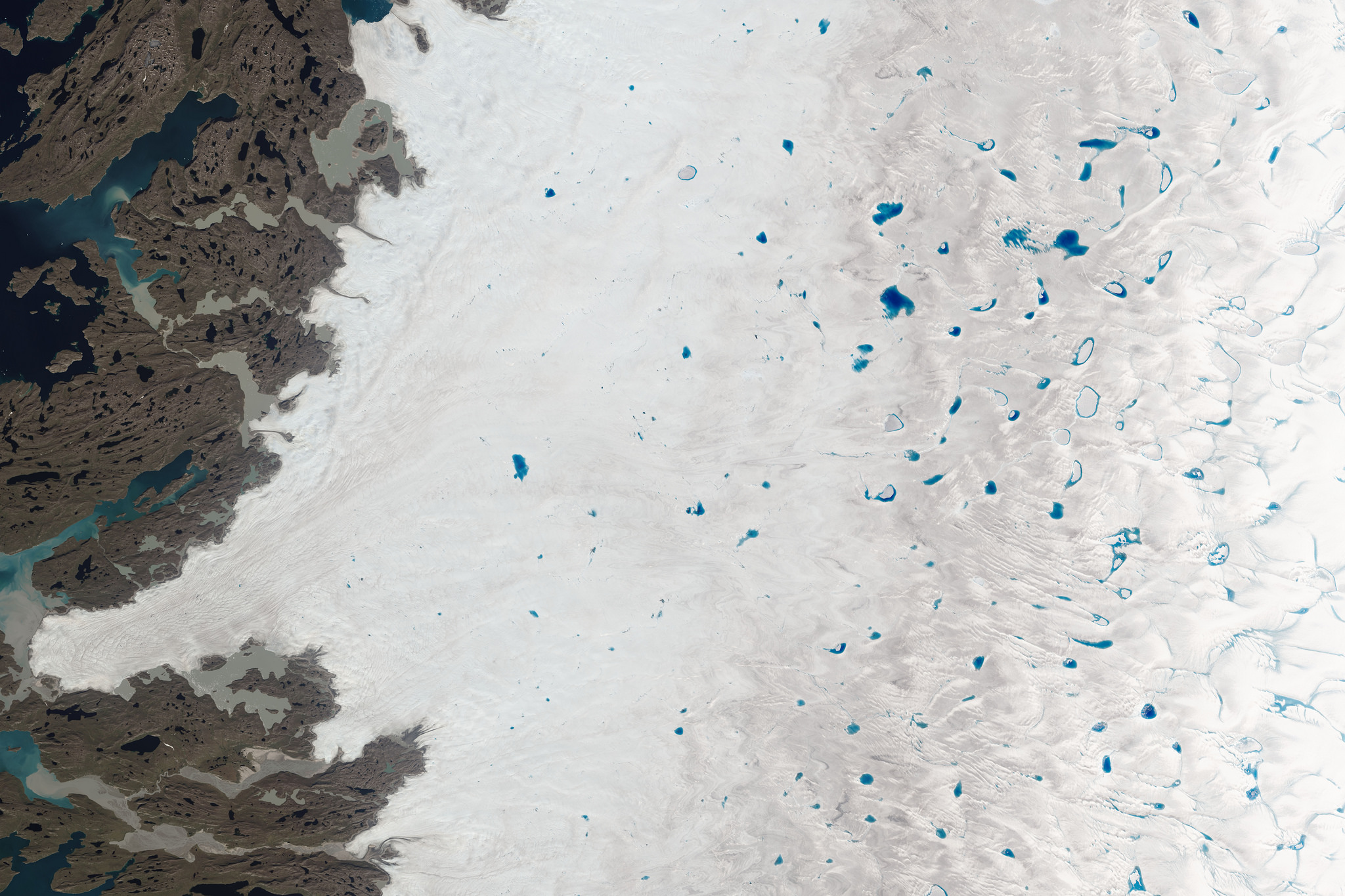 [Shades of Blue on the Greenland Ice Sheet, July 15, 2015]
Landsat 8 has also made mapping the movement of glaciers, ice sheets, and sea ice easier. This in turn has led to the near-real-time global monitoring of glaciers, detailed Antarctic ice sheet velocity maps, and new Antarctic rock outcrop maps, all of which combine to give a better understanding of cryospheric processes.
Landsat 8 also detects more subtle changes in vegetation health and can help make meaningful measurements of biophysical variables that land managers track, like leaf-area index. And with the launch of the European Space Agency's Sentinel-2 satellites, scientists are now "harmonizing" imagery from multiple missions to observe changes to vegetation on seasonal timescales.
This five-year launch anniversary also marks an engineering milestone. Landsat 8 was built with a five-year design life. Most missions that survive their first few months on orbit tend to last much longer than their stated design life. Given that Landsat 8 instruments have few moving parts and the OLI instrument in particular has significant redundancy, scientists and engineers think Landsat 8 will continue operating for years to come.
[Shades of Blue on the Greenland Ice Sheet, July 15, 2015]
Landsat 8 has also made mapping the movement of glaciers, ice sheets, and sea ice easier. This in turn has led to the near-real-time global monitoring of glaciers, detailed Antarctic ice sheet velocity maps, and new Antarctic rock outcrop maps, all of which combine to give a better understanding of cryospheric processes.
Landsat 8 also detects more subtle changes in vegetation health and can help make meaningful measurements of biophysical variables that land managers track, like leaf-area index. And with the launch of the European Space Agency's Sentinel-2 satellites, scientists are now "harmonizing" imagery from multiple missions to observe changes to vegetation on seasonal timescales.
This five-year launch anniversary also marks an engineering milestone. Landsat 8 was built with a five-year design life. Most missions that survive their first few months on orbit tend to last much longer than their stated design life. Given that Landsat 8 instruments have few moving parts and the OLI instrument in particular has significant redundancy, scientists and engineers think Landsat 8 will continue operating for years to come.
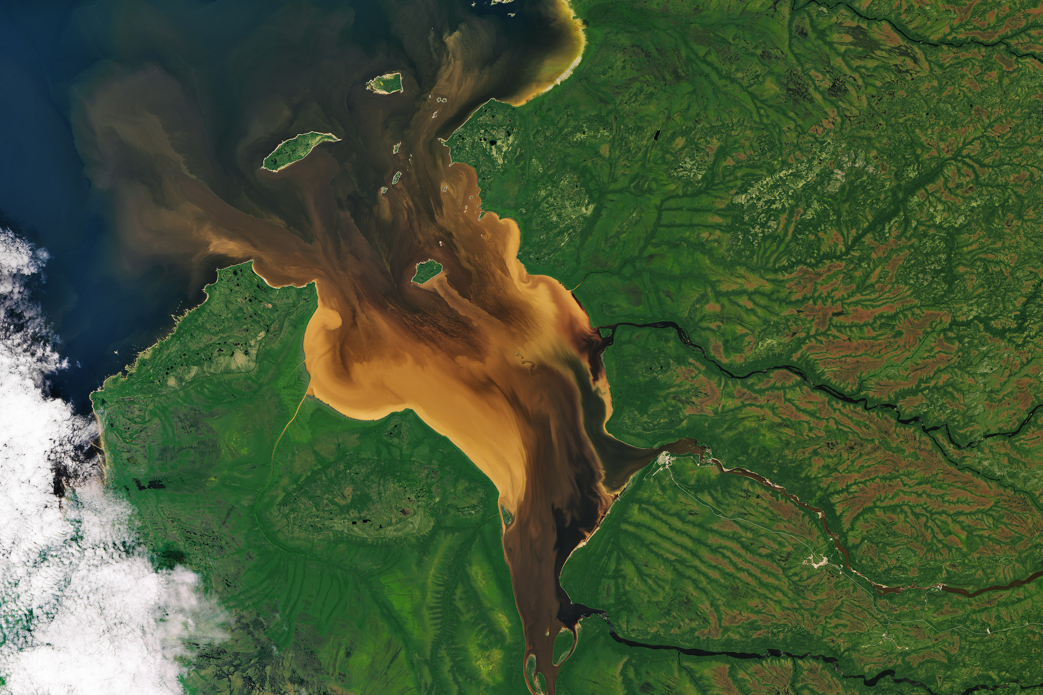 [Remote Rupert Bay in northern Quebec, July 30, 2016. the rivers that flow into Rupert Bay often carry water stained brown with tannins and lignins, chemical substances found in plants. Tannins and lignins from roots, leaves, seeds, bark, and soil can leach into the water and give it a yellow, brown, or even black color.]
"I expect Landsat 8 to last well beyond its design life and continue operations deep into the next decade," Irons said.
The first three Landsats were built with one-year design lives but the operational life exceeded that by at least four years for all of them. Landsats 4 and 5 were built with three-year design lives, but operated well beyond that – Landsat 5 operated for nearly 29 years (a feat for the record books). And Landsat 7, launched in 1999, was built with a five-year design life and is now in its 19th year of operation, albeit with some degradation.
Landsat 8’s data quality and collection pace add significantly to the Landsat data record. The combined Landsat archive with its depth, quality, and open access has exposed new avenues to better understanding our planet, and this record will continue into the future. The Landsat series data record and openly available to the public and will continue when future missions, including Landsat 9.
Edited for WeatherNation by Meteorologist Mace Michaels
[Remote Rupert Bay in northern Quebec, July 30, 2016. the rivers that flow into Rupert Bay often carry water stained brown with tannins and lignins, chemical substances found in plants. Tannins and lignins from roots, leaves, seeds, bark, and soil can leach into the water and give it a yellow, brown, or even black color.]
"I expect Landsat 8 to last well beyond its design life and continue operations deep into the next decade," Irons said.
The first three Landsats were built with one-year design lives but the operational life exceeded that by at least four years for all of them. Landsats 4 and 5 were built with three-year design lives, but operated well beyond that – Landsat 5 operated for nearly 29 years (a feat for the record books). And Landsat 7, launched in 1999, was built with a five-year design life and is now in its 19th year of operation, albeit with some degradation.
Landsat 8’s data quality and collection pace add significantly to the Landsat data record. The combined Landsat archive with its depth, quality, and open access has exposed new avenues to better understanding our planet, and this record will continue into the future. The Landsat series data record and openly available to the public and will continue when future missions, including Landsat 9.
Edited for WeatherNation by Meteorologist Mace Michaels
[This gif shows the Landsat Data Continuity Mission (LDCM) spacecraft successfully separating from the booster. Credits: NASA]
Landsat 8, which before launch was called the Landsat Data Continuity Mission, launched into orbit on Feb. 11, 2013. Once it became operational and was renamed Landsat 8, the satellite continued a streak of engineering and science success unmatched in spaceflight: the succession of Landsat satellites has now made 45-plus years of continuous observations of Earth's surface, without any gaps.
The length of this record is what makes Landsat a "cornerstone" program in the growing field of land imaging. For scientists that want to compare new imagery or data to previous decades, the unbroken Landsat record offers the one, consistent reference point. This role is furthered by USGS’s and NASA's commitment to keeping the entire Landsat data archive free and accessible to scientists and the public. Landsat 9 is targeting a launch in 2020 and will continue that role.
At a time when more commercial imagers are operating, "Landsat 9 will launch into this mix and continue to provide the stability and reliability necessary to systematically study Earth surface dynamics,” Irons said.
[Image On July 28, 2015, the Operational Land Imager (OLI) on Landsat 8 captured these images of algal blooms around the Great Lakes. The bloom is visible as swirls of green in Lake St. Clair. Credit: NASA Earth Observatory]
Landsat 8 benefits from evolutionary technological advances over its predecessors. Landsat 8’s Operational Land Imager (OLI) collects data in two new spectral bands: a deep blue (coastal/aerosol) band and a cirrus cloud detection band. Both of Landsat 8’s science instruments, OLI and the Thermal Infrared Sensor (TIRS), can outperform their predecessors’ measurement sensitivity due to an improved signal-to-noise ratio (SNR).
These improvements have been integral to the work of water quality managers who can now use Landsat 8 to map water quality indicators in coastal and inland waters.
"We can now pull out detailed maps of water constituents, including chlorophyll, dissolved organic matter, and suspended sediment," says Jeff Masek, the Landsat 9 Project Scientist.
[Shades of Blue on the Greenland Ice Sheet, July 15, 2015]
Landsat 8 has also made mapping the movement of glaciers, ice sheets, and sea ice easier. This in turn has led to the near-real-time global monitoring of glaciers, detailed Antarctic ice sheet velocity maps, and new Antarctic rock outcrop maps, all of which combine to give a better understanding of cryospheric processes.
Landsat 8 also detects more subtle changes in vegetation health and can help make meaningful measurements of biophysical variables that land managers track, like leaf-area index. And with the launch of the European Space Agency's Sentinel-2 satellites, scientists are now "harmonizing" imagery from multiple missions to observe changes to vegetation on seasonal timescales.
This five-year launch anniversary also marks an engineering milestone. Landsat 8 was built with a five-year design life. Most missions that survive their first few months on orbit tend to last much longer than their stated design life. Given that Landsat 8 instruments have few moving parts and the OLI instrument in particular has significant redundancy, scientists and engineers think Landsat 8 will continue operating for years to come.
[Remote Rupert Bay in northern Quebec, July 30, 2016. the rivers that flow into Rupert Bay often carry water stained brown with tannins and lignins, chemical substances found in plants. Tannins and lignins from roots, leaves, seeds, bark, and soil can leach into the water and give it a yellow, brown, or even black color.]
"I expect Landsat 8 to last well beyond its design life and continue operations deep into the next decade," Irons said.
The first three Landsats were built with one-year design lives but the operational life exceeded that by at least four years for all of them. Landsats 4 and 5 were built with three-year design lives, but operated well beyond that – Landsat 5 operated for nearly 29 years (a feat for the record books). And Landsat 7, launched in 1999, was built with a five-year design life and is now in its 19th year of operation, albeit with some degradation.
Landsat 8’s data quality and collection pace add significantly to the Landsat data record. The combined Landsat archive with its depth, quality, and open access has exposed new avenues to better understanding our planet, and this record will continue into the future. The Landsat series data record and openly available to the public and will continue when future missions, including Landsat 9.
Edited for WeatherNation by Meteorologist Mace MichaelsAll Weather News
More
Heavy Rain Returns to Texas This Weekend
It's been a week since the devastating floods
12 Jul 2025 3:10 AM

Medium Range Tropics Forecast Favors Gulf, CSU Updates Seasonal Forecast
While the Atlantic appears quiet, conditions
12 Jul 2025 3:05 AM

Elevated Tornado Risk Targets the Midwest Friday
Friday was another busy day with severe weath
12 Jul 2025 3:00 AM

Storms Return From the Front Range to Texas
Moisture is moving back into the Central and
12 Jul 2025 2:50 AM

Timeline: How Catastrophic Flooding Unfolded in Texas Hill Country
TEXAS - Catastrophic flooding devastated port
11 Jul 2025 10:00 AM

Severe Thunderstorms Expected Across the East Coast
The severe weather and flood threat continues
11 Jul 2025 2:35 AM

Ruidoso Flash Flooding - Record Crest for the Rio Ruidoso River
A slow-moving monsoonal thunderstorm develope
10 Jul 2025 1:55 AM