Meteorological Spring is Here! A Look at NOAA's Spring Outlook

Special Stories
1 Mar 2019 1:59 PM
[Spring tulips photo by Aaron Burden on Unsplash]
After a cold and snowy winter in many areas of the nation, meteorological spring has arrived! Last week, the Climate Prediction Center (CPC) issued their 90 day outlook for March, April and May. Warmer than normal temperatures are favored in the eastern and western sections of the nation. Wetter than average weather is expected from the Four Corners to the Middle Atlantic, including the southern Plains and Southeast.
https://twitter.com/NWSCPC/status/1098632029011431424
With many areas of the nation expected to see average to above normal precipitation, the drought outlook continues to show improvement. Across much of the West, with the exception of a few locations in the Northwest, drought conditions are expected to improve or end.
https://twitter.com/NWSCPC/status/1098585966053335042
The main forecast influences were global weather patterns, long range model forecasts, observed soil moisture and snowfall coverage conditions, and historical trends. An extensively discussed El Nino is underway in the Pacific Ocean, but the atmosphere was slow to respond. In early February, an El Nino Advisory was issued as the atmosphere is more aligned with the ocean.
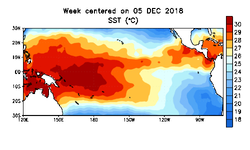 [Departure from average of the surface and subsurface tropical Pacific sea temperature averaged weekly over winter. Map is centered over the Pacific Ocean along the equator. Data from NOAA CPC.]
Observed sea surface temperatures in the Pacific are warmer than normal as expected, with computer models expecting this to continue. Right now, the overall global pattern resembles a weak, borderline El Nino. The CPC says "climate effects typically associated with El Nino during the spring were considered, but downplayed significantly."
For WeatherNation: Meteorologist Mace Michaels
[Departure from average of the surface and subsurface tropical Pacific sea temperature averaged weekly over winter. Map is centered over the Pacific Ocean along the equator. Data from NOAA CPC.]
Observed sea surface temperatures in the Pacific are warmer than normal as expected, with computer models expecting this to continue. Right now, the overall global pattern resembles a weak, borderline El Nino. The CPC says "climate effects typically associated with El Nino during the spring were considered, but downplayed significantly."
For WeatherNation: Meteorologist Mace MichaelsAll Weather News
More
Wildfire Outbreak in the Pacific Northwest
SPOKANE, WA - On Saturday, August 1st, the Ol
2 Aug 2026 7:20 PM

More Storms for the East Through Monday
A low-pressure system that moved through the
2 Aug 2026 7:20 PM


After Reaching Category 5, Genevieve Weakens in the Pacific
PacificGenevieve formed on last Friday south
2 Aug 2026 6:25 PM

Flooding, Severe Storms Target the Midwest Again
After an active week of storms across the nor
1 Aug 2026 1:40 AM

Flooding Risk Increases as Heavy Rain Targets the Tri-State Area
Tuesday, heavy rainfall moved across the Nort
30 Jul 2026 12:25 AM

Severe Weather: Energy From the Midwest Now in the Southeast
UPPER MIDWEST - Through Monday, dangerous tor
29 Jul 2026 10:30 PM