Much of the Country Experiences Sharp Temperature Drop
Top Stories
11 Jan 2018 10:16 PM
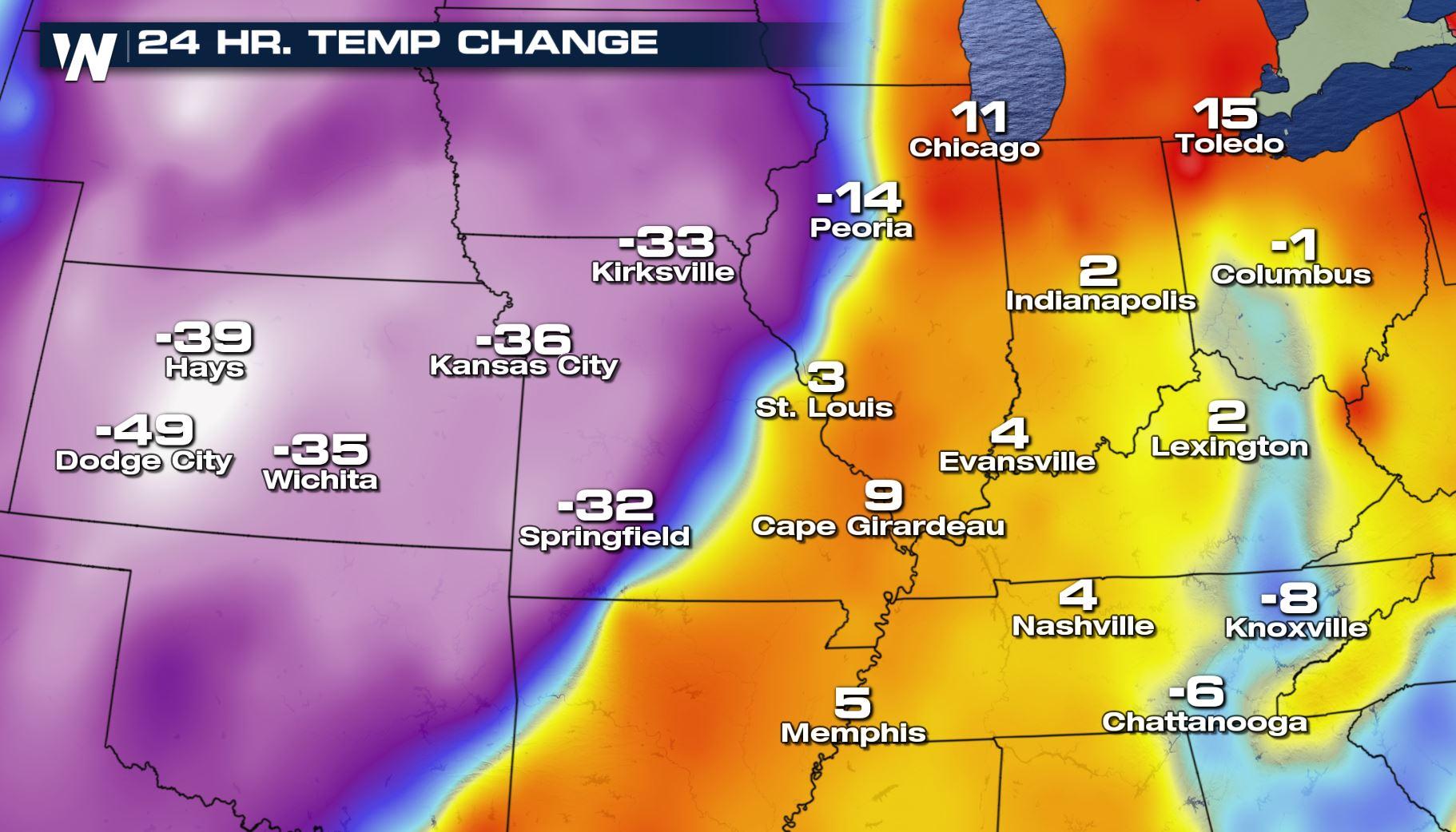
As the ongoing winter storm pushed across the Lower 48 Thursday, many areas observed some very strong temperature swings. Areas ahead of the sharp cold front saw record numbers, rising from 50 to 70 degrees in spots. Behind the cold front it was a different story.
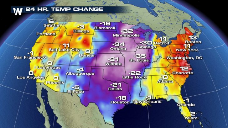 The temperature change between Wednesday evening to Thursday evening.
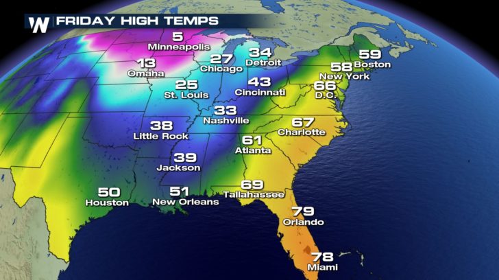
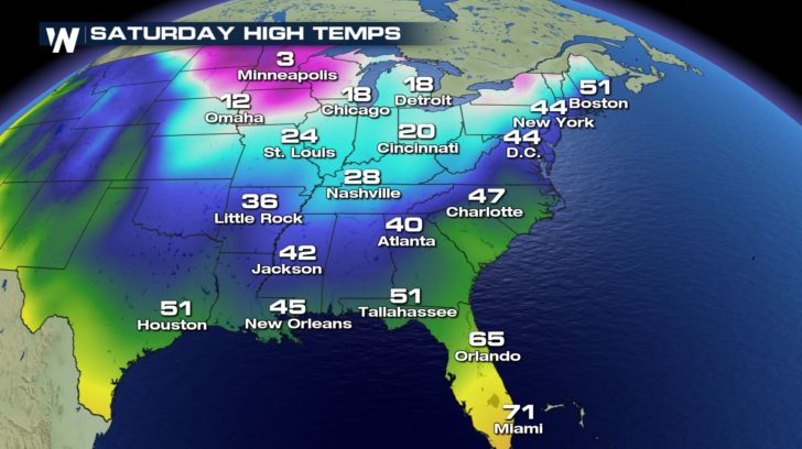
This sharply colder weather will continue its onward movement to the east Friday.
https://twitter.com/WeatherNation/status/951659529468456960
A week after temperatures were well below average, it appears the record warmth will be short-lived this time around.
https://twitter.com/WeatherNation/status/951618267419787265
https://twitter.com/WeatherNation/status/951637128395370496
The cold air rushing in will change the precipitation from rain to freezing rain, sleet, and possibly snow for portions of the central and eastern United States. We have written a few articles on the impacts, timing, amounts, etc. and you can find all that information by clicking or tapping here!
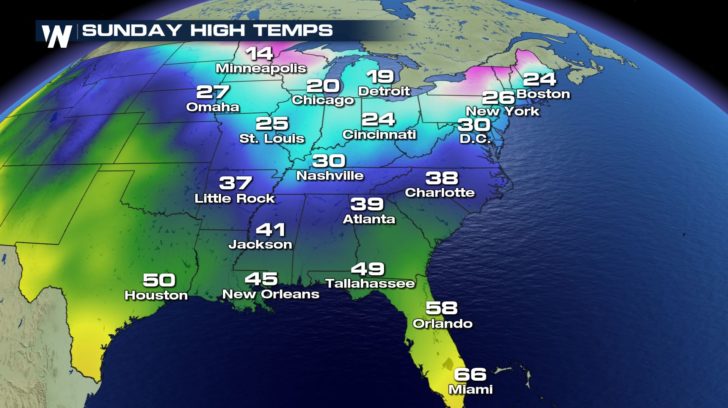
The colder air will arrive on the eastern side of the country by the weekend.
The temperature change between Wednesday evening to Thursday evening.
This sharply colder weather will continue its onward movement to the east Friday.
https://twitter.com/WeatherNation/status/951659529468456960
A week after temperatures were well below average, it appears the record warmth will be short-lived this time around.
https://twitter.com/WeatherNation/status/951618267419787265
https://twitter.com/WeatherNation/status/951637128395370496
The cold air rushing in will change the precipitation from rain to freezing rain, sleet, and possibly snow for portions of the central and eastern United States. We have written a few articles on the impacts, timing, amounts, etc. and you can find all that information by clicking or tapping here!
The colder air will arrive on the eastern side of the country by the weekend.
 For WeatherNation, Meteorologist Steve Glazier
The temperature change between Wednesday evening to Thursday evening.
This sharply colder weather will continue its onward movement to the east Friday.
https://twitter.com/WeatherNation/status/951659529468456960
A week after temperatures were well below average, it appears the record warmth will be short-lived this time around.
https://twitter.com/WeatherNation/status/951618267419787265
https://twitter.com/WeatherNation/status/951637128395370496
The cold air rushing in will change the precipitation from rain to freezing rain, sleet, and possibly snow for portions of the central and eastern United States. We have written a few articles on the impacts, timing, amounts, etc. and you can find all that information by clicking or tapping here!
The colder air will arrive on the eastern side of the country by the weekend.
For WeatherNation, Meteorologist Steve GlazierAll Weather News
More
Storms Return From the Front Range to Texas
Moisture is moving back into the Central and
10 Jul 2025 10:45 PM

Medium Range Tropics Forecast Favors Gulf, CSU Updates Seasonal Forecast
While the Atlantic appears quiet, conditions
10 Jul 2025 10:40 PM

Severe Thunderstorms Expected Across the East Coast
The severe weather and flood threat continues
10 Jul 2025 10:30 PM

Rounds of Severe Storms to Impact Great Plains and Midwest Through the Weekend
A dynamic summer weather pattern is setting t
10 Jul 2025 10:25 PM

Timeline: How Catastrophic Flooding Unfolded in Texas Hill Country
TEXAS - Catastrophic flooding devastated port
10 Jul 2025 10:00 AM

Ruidoso Flash Flooding - Record Crest for the Rio Ruidoso River
A slow-moving monsoonal thunderstorm develope
10 Jul 2025 1:55 AM
