New Weather Model May Increase Tornado Warning Lead Times
Special Stories
3 Oct 2018 9:08 AM
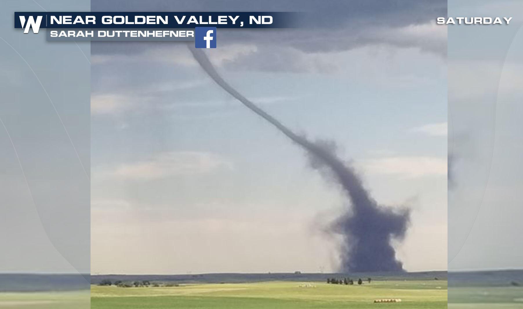
[Tornado in North Dakota captured earlier this year by Sarah Duttenhefner]
[PSU] Improved short-term forecasts for tornadoes and supercell thunderstorms is on the horizon. Researchers at Penn State University are the first to use data obtained from recent next-generation satellites in a numerical weather-prediction model used to provide guidance for tornadic thunderstorm forecasting. GOES-16, which was launched in 2016, recently became fully operational but methods for incorporating the data, did not exist until now.
A method for an all-sky infrared radiance has been developed through Penn State's Center for Advanced Data Assimilation and Predictability Techniques (ADAPT), to incorporate data into models for weather events in the Midwest. The experiments were "hindcast", meaning the models were run after the weather event and compared with what actual happened. The model was able to forecast supercell thunderstorms with atmospheric conditions that are very conducive to tornadoes.
The results, reported in Monthly Weather Review published by the American Meteorological Society, suggest that we can greatly enhance our ability to predict thunderstorms capable of producing tornadoes.
 [This 16-panel image shows a snapshot of the continental U.S. and surrounding oceans from each of the Advanced Baseline Imager channels on July 29. This imagery was captured between the instrument’s “cool” and “warm” season, when all 16 channels are available 24 hours per day. During the instrument’s “warm” seasons, varied data outages are expected for 9 of the channels during nighttime hours. The ABI’s increased channels provide three times more spectral information than the previous GOES imager. Credit: NOAA/NASA]
"It’s not just the data that’s important," Fuqing Zhang, professor of meteorology at PSU and director of ADAPT said. "It’s how we design very sophisticated numerical mathematical algorithms to ingest that satellite data into the model. This is really our expertise and our pride. Our team is the first to be able to effectively take in this high resolution satellite data and prove it can be useful in real-case scenarios."
Forecasting tornadic thunderstorms is important because these events are especially quick to form, hard to predict, and can cause catastrophic damage. Thunderstorms account for 40 percent of all severe weather events in the United States, causing 14 percent of damage and 17 percent of related deaths, according to the National Climate Data Center.
"For many storms in the United States, we have good radar data, however, it's very hard using any of the existing technologies to capture the environmental and storm conditions before the storm totally develops," Zhang said. "We're able to extend the warning time for these events because the satellite can look at the field even before the clouds form and our models can ingest that information to improve and advance forecasts."
In the past 40 years, tornado warning lead-time — meaning the time interval between when a warning is issued and the tornado occurs — has increased on average from 3 to 14 minutes. Zhang said this method could extend the lead time even further.
[This 16-panel image shows a snapshot of the continental U.S. and surrounding oceans from each of the Advanced Baseline Imager channels on July 29. This imagery was captured between the instrument’s “cool” and “warm” season, when all 16 channels are available 24 hours per day. During the instrument’s “warm” seasons, varied data outages are expected for 9 of the channels during nighttime hours. The ABI’s increased channels provide three times more spectral information than the previous GOES imager. Credit: NOAA/NASA]
"It’s not just the data that’s important," Fuqing Zhang, professor of meteorology at PSU and director of ADAPT said. "It’s how we design very sophisticated numerical mathematical algorithms to ingest that satellite data into the model. This is really our expertise and our pride. Our team is the first to be able to effectively take in this high resolution satellite data and prove it can be useful in real-case scenarios."
Forecasting tornadic thunderstorms is important because these events are especially quick to form, hard to predict, and can cause catastrophic damage. Thunderstorms account for 40 percent of all severe weather events in the United States, causing 14 percent of damage and 17 percent of related deaths, according to the National Climate Data Center.
"For many storms in the United States, we have good radar data, however, it's very hard using any of the existing technologies to capture the environmental and storm conditions before the storm totally develops," Zhang said. "We're able to extend the warning time for these events because the satellite can look at the field even before the clouds form and our models can ingest that information to improve and advance forecasts."
In the past 40 years, tornado warning lead-time — meaning the time interval between when a warning is issued and the tornado occurs — has increased on average from 3 to 14 minutes. Zhang said this method could extend the lead time even further.
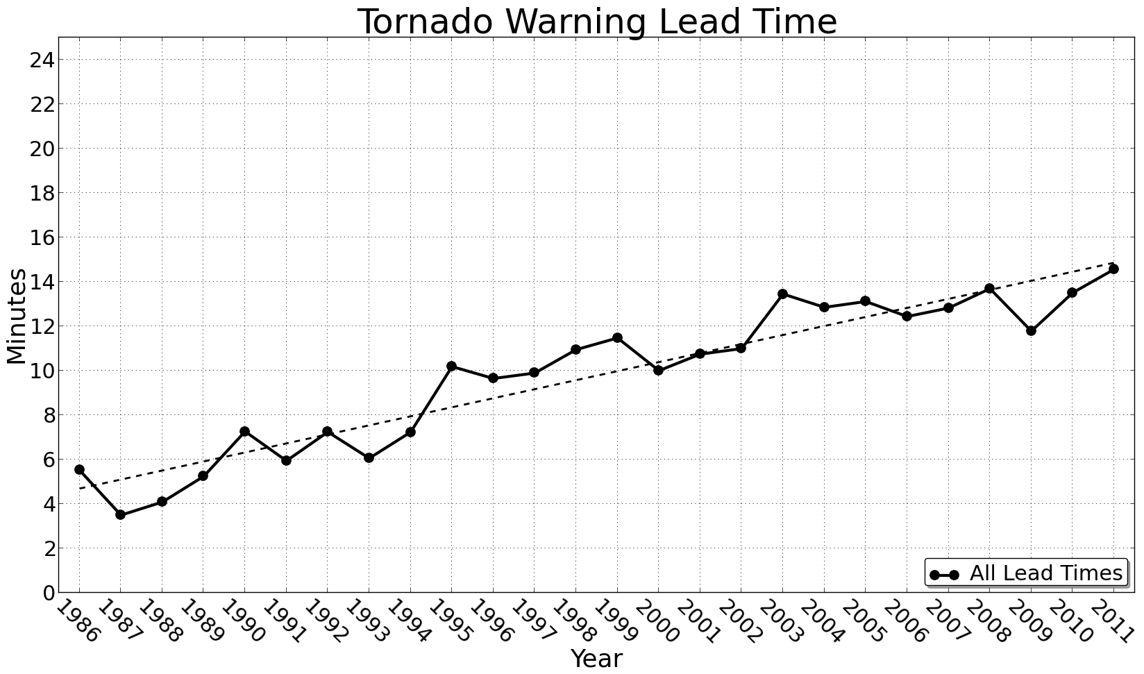 [Tornado Warning lead times. From Patrick Marsh, Storm Prediction Center]
"Researchers have made huge improvements in tornado lead times but, for many people, 14 minutes isn't enough," said David Stensrud, head of the Department of Meteorology and Atmospheric Science at Penn State. "If you have a big sports stadium or a hospital it takes more than 14 minutes to prepare for the weather threat. There is certainly a need for more advanced warnings. Our research indicates that by combining data assimilation and high-resolution models we can get lead times beyond 30 minutes. Doubling the lead time would have huge potential societal impacts."
Better models and better data supplied by GOES-16 could also reduce false alarm rates, he said. Researchers are working with NOAA and the National Weather Service to ready the algorithms for ingesting these satellite data for widespread use.
Satellite data has proven tricky for use in weather models because satellites do not capture key variables such as wind speed, pressure, temperature and water vapor. But satellites capture data known as brightness temperature, which show how much radiation is emitted by objects on Earth and in the atmosphere at different infrared frequencies. Using all-sky radiance, researchers can use brightness temperature captured at different frequencies to paint a picture of cloud formations and water vapor fields.
[Tornado Warning lead times. From Patrick Marsh, Storm Prediction Center]
"Researchers have made huge improvements in tornado lead times but, for many people, 14 minutes isn't enough," said David Stensrud, head of the Department of Meteorology and Atmospheric Science at Penn State. "If you have a big sports stadium or a hospital it takes more than 14 minutes to prepare for the weather threat. There is certainly a need for more advanced warnings. Our research indicates that by combining data assimilation and high-resolution models we can get lead times beyond 30 minutes. Doubling the lead time would have huge potential societal impacts."
Better models and better data supplied by GOES-16 could also reduce false alarm rates, he said. Researchers are working with NOAA and the National Weather Service to ready the algorithms for ingesting these satellite data for widespread use.
Satellite data has proven tricky for use in weather models because satellites do not capture key variables such as wind speed, pressure, temperature and water vapor. But satellites capture data known as brightness temperature, which show how much radiation is emitted by objects on Earth and in the atmosphere at different infrared frequencies. Using all-sky radiance, researchers can use brightness temperature captured at different frequencies to paint a picture of cloud formations and water vapor fields.
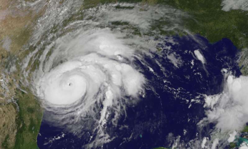 [Hurricane Harvey from 2017, right before landfall along the Texas coastline. From NOAA]
In research that's still under review and profiled in Nature, Zhang and his colleagues show this method forecast that Hurricane Harvey would reach a category 4 while existing models forecast it as a category 1. Harvey became the first category 4 hurricane to make landfall along the Texas coast since 1961.
GOES-16 covers one-sixth of the Earth, including the Eastern portion of the United States and all of the Atlantic Ocean, and is geostationary. It replaces GOES-13, offering data resolution at a scale slightly larger than half a mile, much better than its predecessor at 2.5 miles, and with data available every 5 minutes or less.
The increased spatial and temporal resolution is important because it offers much more information about what is taking place within thunderstorms, hurricanes and other severe weather events. The satellite uses 16 bands of image data using visible and infrared light to reveal factors such as fog, winds, vegetation, snow and ice, fires, water vapor and lightning. It is one of three similar satellites in operation that collectively cover nearly all habitable land and surrounding oceans.
Edited for WeatherNation by Meteorologist Mace Michaels
[Hurricane Harvey from 2017, right before landfall along the Texas coastline. From NOAA]
In research that's still under review and profiled in Nature, Zhang and his colleagues show this method forecast that Hurricane Harvey would reach a category 4 while existing models forecast it as a category 1. Harvey became the first category 4 hurricane to make landfall along the Texas coast since 1961.
GOES-16 covers one-sixth of the Earth, including the Eastern portion of the United States and all of the Atlantic Ocean, and is geostationary. It replaces GOES-13, offering data resolution at a scale slightly larger than half a mile, much better than its predecessor at 2.5 miles, and with data available every 5 minutes or less.
The increased spatial and temporal resolution is important because it offers much more information about what is taking place within thunderstorms, hurricanes and other severe weather events. The satellite uses 16 bands of image data using visible and infrared light to reveal factors such as fog, winds, vegetation, snow and ice, fires, water vapor and lightning. It is one of three similar satellites in operation that collectively cover nearly all habitable land and surrounding oceans.
Edited for WeatherNation by Meteorologist Mace Michaels
[This 16-panel image shows a snapshot of the continental U.S. and surrounding oceans from each of the Advanced Baseline Imager channels on July 29. This imagery was captured between the instrument’s “cool” and “warm” season, when all 16 channels are available 24 hours per day. During the instrument’s “warm” seasons, varied data outages are expected for 9 of the channels during nighttime hours. The ABI’s increased channels provide three times more spectral information than the previous GOES imager. Credit: NOAA/NASA]
"It’s not just the data that’s important," Fuqing Zhang, professor of meteorology at PSU and director of ADAPT said. "It’s how we design very sophisticated numerical mathematical algorithms to ingest that satellite data into the model. This is really our expertise and our pride. Our team is the first to be able to effectively take in this high resolution satellite data and prove it can be useful in real-case scenarios."
Forecasting tornadic thunderstorms is important because these events are especially quick to form, hard to predict, and can cause catastrophic damage. Thunderstorms account for 40 percent of all severe weather events in the United States, causing 14 percent of damage and 17 percent of related deaths, according to the National Climate Data Center.
"For many storms in the United States, we have good radar data, however, it's very hard using any of the existing technologies to capture the environmental and storm conditions before the storm totally develops," Zhang said. "We're able to extend the warning time for these events because the satellite can look at the field even before the clouds form and our models can ingest that information to improve and advance forecasts."
In the past 40 years, tornado warning lead-time — meaning the time interval between when a warning is issued and the tornado occurs — has increased on average from 3 to 14 minutes. Zhang said this method could extend the lead time even further.
[Tornado Warning lead times. From Patrick Marsh, Storm Prediction Center]
"Researchers have made huge improvements in tornado lead times but, for many people, 14 minutes isn't enough," said David Stensrud, head of the Department of Meteorology and Atmospheric Science at Penn State. "If you have a big sports stadium or a hospital it takes more than 14 minutes to prepare for the weather threat. There is certainly a need for more advanced warnings. Our research indicates that by combining data assimilation and high-resolution models we can get lead times beyond 30 minutes. Doubling the lead time would have huge potential societal impacts."
Better models and better data supplied by GOES-16 could also reduce false alarm rates, he said. Researchers are working with NOAA and the National Weather Service to ready the algorithms for ingesting these satellite data for widespread use.
Satellite data has proven tricky for use in weather models because satellites do not capture key variables such as wind speed, pressure, temperature and water vapor. But satellites capture data known as brightness temperature, which show how much radiation is emitted by objects on Earth and in the atmosphere at different infrared frequencies. Using all-sky radiance, researchers can use brightness temperature captured at different frequencies to paint a picture of cloud formations and water vapor fields.
[Hurricane Harvey from 2017, right before landfall along the Texas coastline. From NOAA]
In research that's still under review and profiled in Nature, Zhang and his colleagues show this method forecast that Hurricane Harvey would reach a category 4 while existing models forecast it as a category 1. Harvey became the first category 4 hurricane to make landfall along the Texas coast since 1961.
GOES-16 covers one-sixth of the Earth, including the Eastern portion of the United States and all of the Atlantic Ocean, and is geostationary. It replaces GOES-13, offering data resolution at a scale slightly larger than half a mile, much better than its predecessor at 2.5 miles, and with data available every 5 minutes or less.
The increased spatial and temporal resolution is important because it offers much more information about what is taking place within thunderstorms, hurricanes and other severe weather events. The satellite uses 16 bands of image data using visible and infrared light to reveal factors such as fog, winds, vegetation, snow and ice, fires, water vapor and lightning. It is one of three similar satellites in operation that collectively cover nearly all habitable land and surrounding oceans.
Edited for WeatherNation by Meteorologist Mace MichaelsAll Weather News
More
Heavy Rain Returns to Texas This Weekend
It's been a week since the devastating floods
12 Jul 2025 3:10 AM

Medium Range Tropics Forecast Favors Gulf, CSU Updates Seasonal Forecast
While the Atlantic appears quiet, conditions
12 Jul 2025 3:05 AM

Elevated Tornado Risk Targets the Midwest Friday
Friday was another busy day with severe weath
12 Jul 2025 3:00 AM

Storms Return From the Front Range to Texas
Moisture is moving back into the Central and
12 Jul 2025 2:50 AM

Timeline: How Catastrophic Flooding Unfolded in Texas Hill Country
TEXAS - Catastrophic flooding devastated port
11 Jul 2025 10:00 AM

Severe Thunderstorms Expected Across the East Coast
The severe weather and flood threat continues
11 Jul 2025 2:35 AM

Ruidoso Flash Flooding - Record Crest for the Rio Ruidoso River
A slow-moving monsoonal thunderstorm develope
10 Jul 2025 1:55 AM