NOAA & Climate Predication Center Release 2022-2023 Seasonal Winter Outlook
Special Stories
23 Oct 2022 4:00 AM
On October 20th, the National Oceanic and Atmospheric Administration (NOAA) released its annual prediction of what the most likely scenarios are for this upcoming winter. Alongside the Climate Prediction Center, CPC, NOAA hosted a media briefing discussing the expectations into 2023. Meteorologists and Climatologists highlighted the areas that are expected to be cooler or warmer-than-average, while showing the spots that are forecast to be wetter or drier-than-average.
https://www.youtube.com/watch?v=6I2aHCN5Xcs
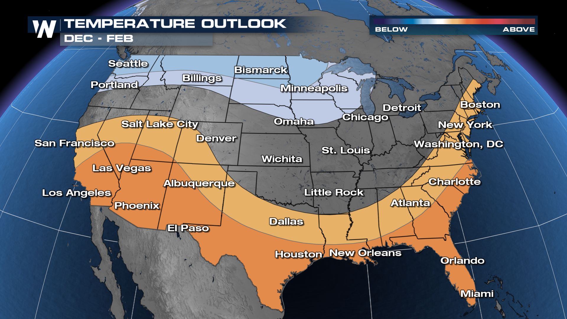
This year, NOAA forecasts a cooler than average winter for the Pacific Northwest, Northern Rockies and High Plains. The East coast is predicted to be warmer-than-average, as is all of the South from the Carolinas to California. This is extremely characteristic of a La Nina pattern, more on which below.
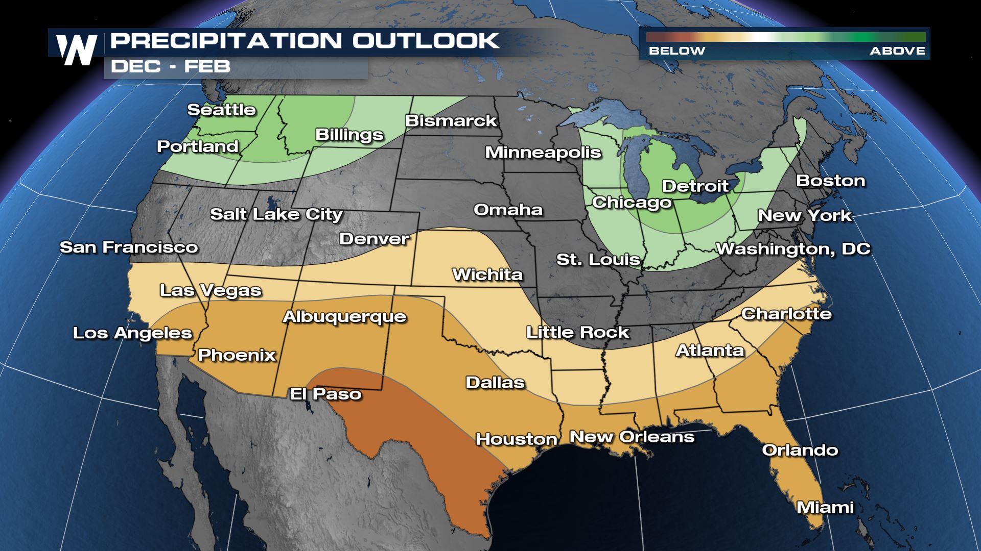
 For precipitation, the Pacific Northwest, northern Rockies and Great Great Lakes region as well as the Midwest have the potential at seeing wetter-than-normal conditions. Meanwhile, we expect the South-Central and parts of the Southwest U.S. across central and south Texas but also up into the Southwest and eastern Gulf to see drier-than-average conditions this weekend. We've had a below normal season for rainfall in the Southern Plains, so this is not the forecast we were hoping for to make up the deficit still present in many states.
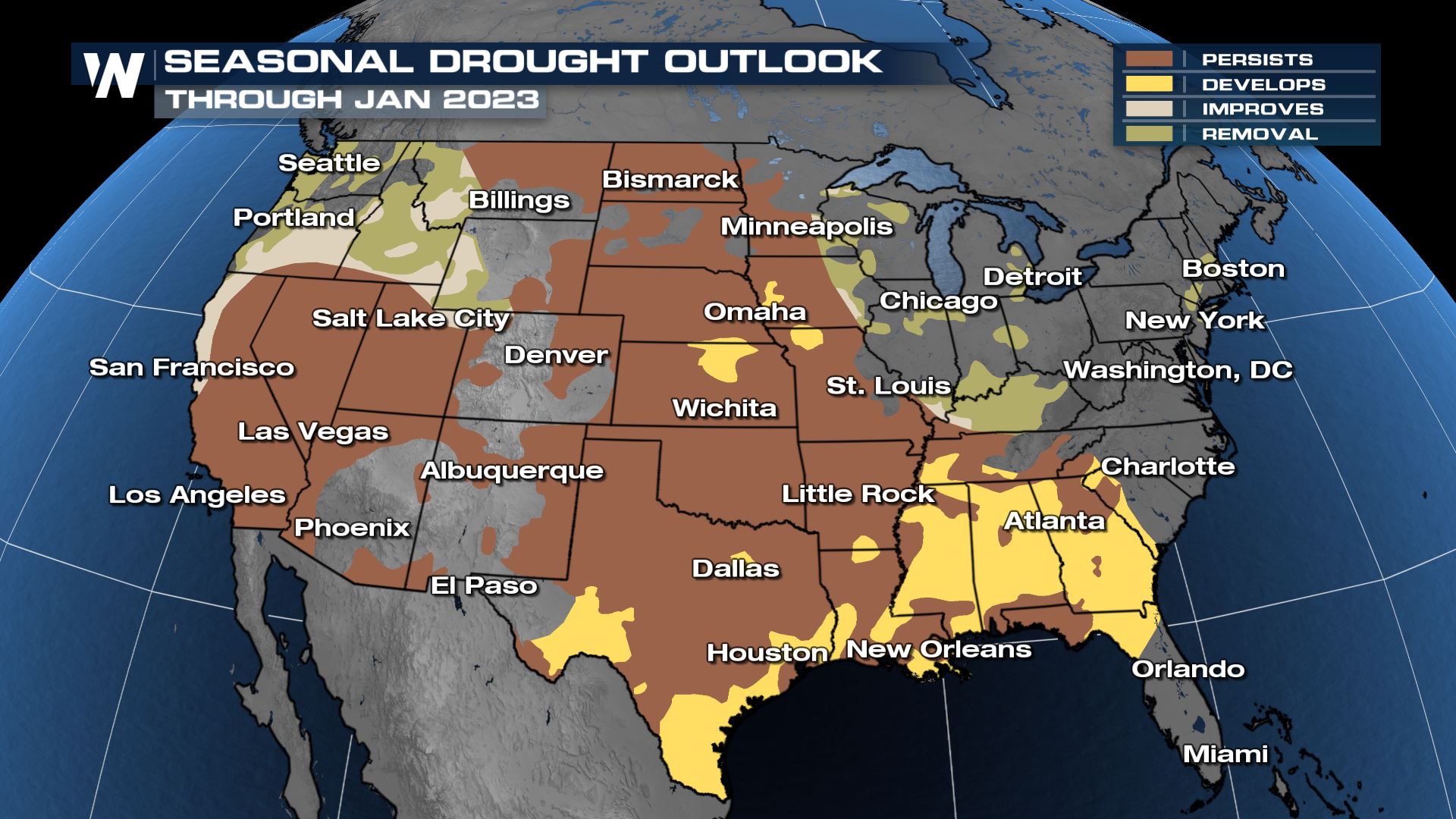
 What this means for ongoing drought is that it is expected to worsen in the Southeast/Eastern Gulf through the winter as well as southern Texas. Many in the central Plains will see the drought continue to persist, along with much of the western U.S.. The Northwest and Ohio Valley should see drought conditions improve (meaning lessening of the drought) or a removal of the drought completely, which would be good news for fire concerns in the Northwest.
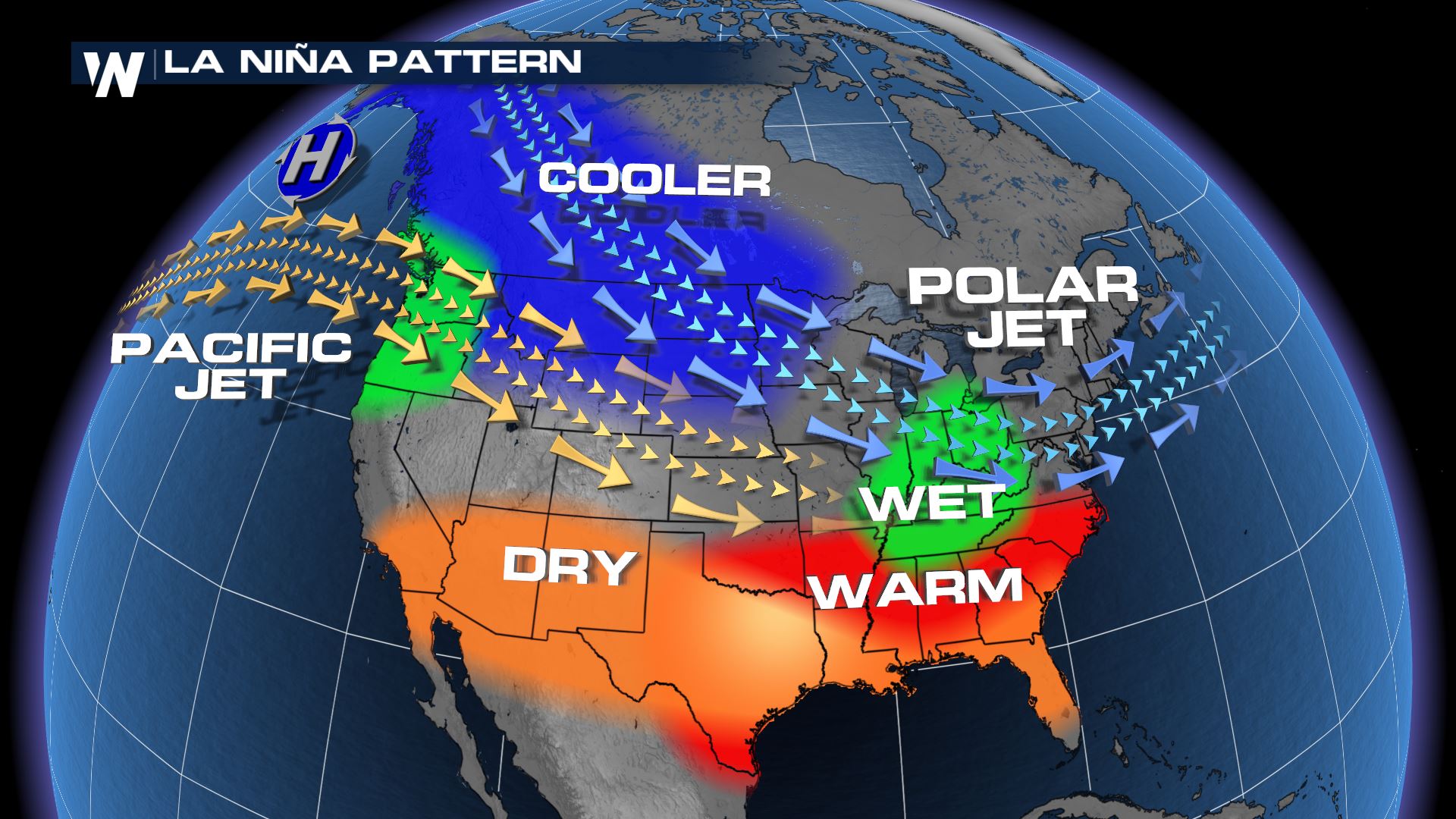
 Last month NOAA & CPC released a statement that the presence of La Nina will be likely through the first half of winter, with less potential into the first part of 2023. La Nina is the term for cooler-than-average ocean temperatures in the equatorial Pacific Ocean. Usually it means the southern tier of the U.S. stays drier and warmer, while parts of the Northwest and Northeast can be wetter. This winter's outlook generally follows the typical La Nina pattern/climatology.
 But why is this year's winter outlook important?
Energy planners and department of transportation agencies remain curious on this topic because the information is important to their planning purposes this winter. For instance, if we know it's going to be a warmer winter, energy planners can budget needs for the next several months. Meanwhile if we believe it's going to be snowier, departments of transportation can request more road treatment in advance. Users of this winter outlook should take special note that the seasonal prediction forecasts the entire winter (roughly now through April). It doesn't forecast specific nor'easters, blizzards, ice storms, or Arctic events. You can have a warmer-than-average winter (in the long run) even if you get an intense cold blast for a week or two. Monitor the day-to-day winter weather forecast here at WeatherNation.
 For precipitation, the Pacific Northwest, northern Rockies and Great Great Lakes region as well as the Midwest have the potential at seeing wetter-than-normal conditions. Meanwhile, we expect the South-Central and parts of the Southwest U.S. across central and south Texas but also up into the Southwest and eastern Gulf to see drier-than-average conditions this weekend. We've had a below normal season for rainfall in the Southern Plains, so this is not the forecast we were hoping for to make up the deficit still present in many states.
 What this means for ongoing drought is that it is expected to worsen in the Southeast/Eastern Gulf through the winter as well as southern Texas. Many in the central Plains will see the drought continue to persist, along with much of the western U.S.. The Northwest and Ohio Valley should see drought conditions improve (meaning lessening of the drought) or a removal of the drought completely, which would be good news for fire concerns in the Northwest.
 Last month NOAA & CPC released a statement that the presence of La Nina will be likely through the first half of winter, with less potential into the first part of 2023. La Nina is the term for cooler-than-average ocean temperatures in the equatorial Pacific Ocean. Usually it means the southern tier of the U.S. stays drier and warmer, while parts of the Northwest and Northeast can be wetter. This winter's outlook generally follows the typical La Nina pattern/climatology.
 But why is this year's winter outlook important?
Energy planners and department of transportation agencies remain curious on this topic because the information is important to their planning purposes this winter. For instance, if we know it's going to be a warmer winter, energy planners can budget needs for the next several months. Meanwhile if we believe it's going to be snowier, departments of transportation can request more road treatment in advance. Users of this winter outlook should take special note that the seasonal prediction forecasts the entire winter (roughly now through April). It doesn't forecast specific nor'easters, blizzards, ice storms, or Arctic events. You can have a warmer-than-average winter (in the long run) even if you get an intense cold blast for a week or two. Monitor the day-to-day winter weather forecast here at WeatherNation.
But why is this year's winter outlook important?
Energy planners and department of transportation agencies remain curious on this topic because the information is important to their planning purposes this winter. For instance, if we know it's going to be a warmer winter, energy planners can budget needs for the next several months. Meanwhile if we believe it's going to be snowier, departments of transportation can request more road treatment in advance. Users of this winter outlook should take special note that the seasonal prediction forecasts the entire winter (roughly now through April). It doesn't forecast specific nor'easters, blizzards, ice storms, or Arctic events. You can have a warmer-than-average winter (in the long run) even if you get an intense cold blast for a week or two. Monitor the day-to-day winter weather forecast here at WeatherNation.All Weather News
More