NOAA Hurricane Expert Looks Back at a Record Setting Hurricane Season
Special Stories
7 Dec 2020 2:00 AM
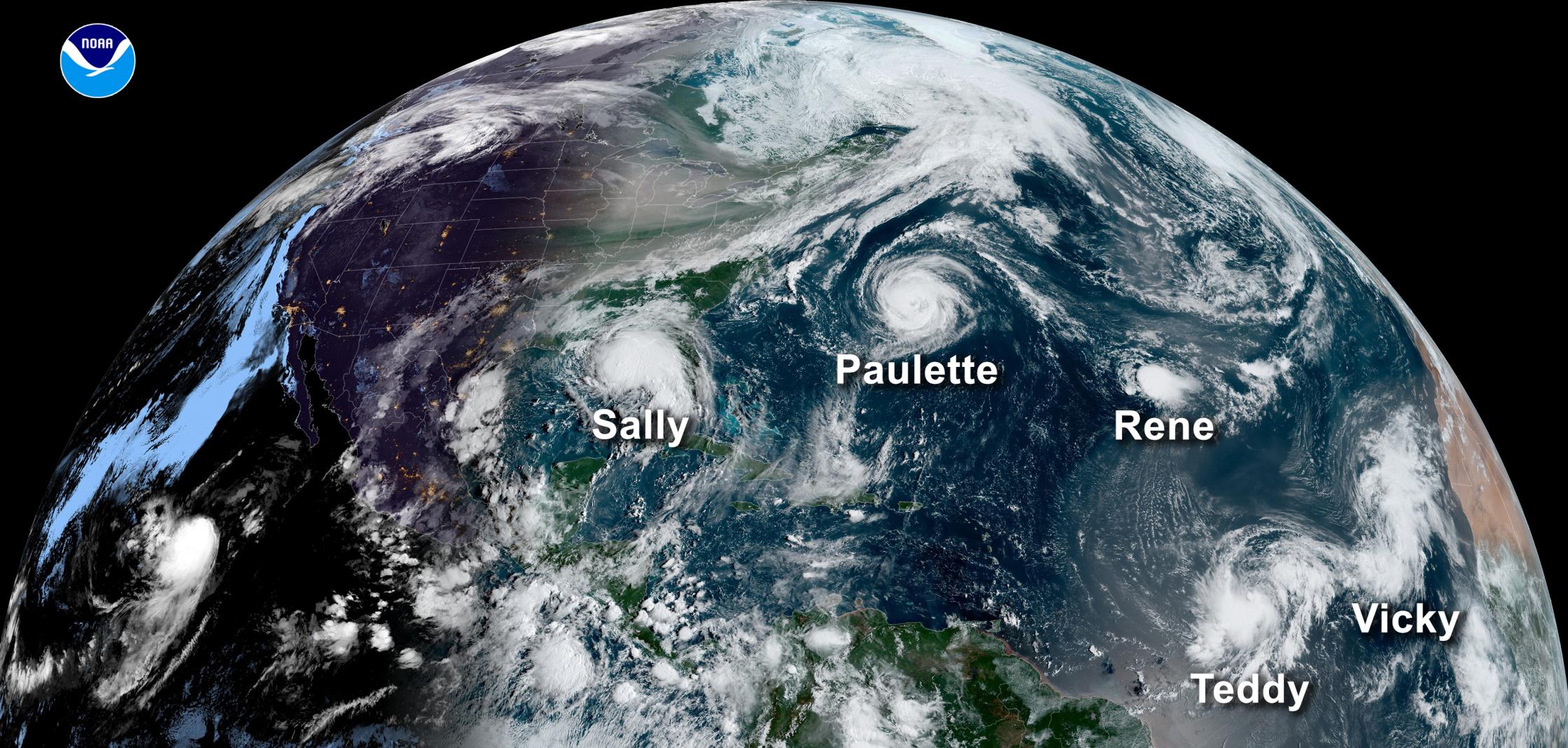
[This image from NOAA's GOES-16 satellite on September 14, 2020, shows five tropical systems spinning in the Atlantic basin at one time. From left to right: Hurricane Sally in the Gulf of Mexico, Hurricane Paulette east of the Carolinas, the remnants of Tropical Storm Rene in the central Atlantic, and Tropical Storms Teddy and Vicky in the eastern Atlantic. A total of 10 named storms formed in September 2020 — the most for any month on record. Image from NOAA]
[Written by NOAA] Jim Kossin is an atmospheric research scientist at NOAA’s Center for Weather and Climate, part of NOAA’s National Centers for Environmental Information (NCEI). His research focuses on extreme storms—in particular tropical cyclones (hurricanes, typhoons)—and their relationship with climate and climate change. We recently sat down with Jim to look back at the record-breaking 2020 Atlantic Hurricane Season as it draws to a close.
The 2020 Atlantic hurricane season was one for the record books. You’ve written many research papers on just about every aspect of tropical cyclones. What about this season stood out to you?
The total number of tropical storms that were named this season has broken the all-time record set in 2005, so this is probably the most noteworthy aspect. But we also saw yet more examples of very rapid intensification and very slow moving hurricanes, both of which have recently been linked to climate change. In 2020, to date, there have been a remarkable ten hurricanes that rapidly intensified (Hanna, Laura, Sally, Teddy, Gamma, Delta, Epsilon, Zeta, Eta and Iota)—some of which underwent explosive intensification—and two hurricanes that practically stopped moving as they made landfall (Sally on the Gulf Coast and Eta in Central America). All of these storms had the potential for causing great damage and loss of life because they were so strong and they lingered for so long.
 [Jim Kossin, NOAA NCEI. Photo credit: Space Science and Engineering Center/Greg Anderson Photography]
What are the reasons some of this year’s storms intensified so quickly? Are we seeing more of these types of storms occurring overall?
The main culprit for the hyper-activity this year was warmer-than-average ocean temperatures. This is also the main reason for the longer-than-average season and the numerous rapid-intensification events. The frequency of rapid-intensification events has increased over the past four decades, and this increase has been linked to climate change. The length of the hurricane season increases by about 40 days per degree Celsius of warming (the season starts about 20 days earlier and lasts about 20 days longer, on average). But the link to climate change for this is not as clear because our understanding of how and why hurricanes form is not as strong as our understanding of how and why hurricanes intensify.
Based on the changing climate, will the hurricane season need to officially start earlier than June 1?
This is a bit tricky. The relationship between global warming and tropical storm formation is less clear than, for example, the relationship between global warming and intensity. There is good consensus that global warming increases intensity, but no strong consensus that warming increases frequency. If there is no clear expectation that global warming increases tropical storm frequency, then there should be no clear expectation that the season will lengthen under global warming. This may seem a bit counterintuitive since the length of the season is influenced by ocean temperatures, as noted just above, and ocean temperatures are influenced by global warming. But this is where things get more complicated. The way that tropical storm formation responds to warming oceans depends strongly on what it was that warmed the ocean. Global warming from greenhouse gases tends to warm the tropics somewhat uniformly and this type of warming is not expected to increase frequency. Regional warming from things like reduced pollution or Saharan dust over the Atlantic ocean does increase frequency. So, in this case, the increased frequency we’ve observed in the Atlantic since around the mid-1990s is most likely due to these regional effects and not so much due to global warming. And if this is true, then we don’t necessarily expect Atlantic storm frequency to continue to increase due to continued global warming. This is one of the frontier research problems that we’re trying to understand better.
[Jim Kossin, NOAA NCEI. Photo credit: Space Science and Engineering Center/Greg Anderson Photography]
What are the reasons some of this year’s storms intensified so quickly? Are we seeing more of these types of storms occurring overall?
The main culprit for the hyper-activity this year was warmer-than-average ocean temperatures. This is also the main reason for the longer-than-average season and the numerous rapid-intensification events. The frequency of rapid-intensification events has increased over the past four decades, and this increase has been linked to climate change. The length of the hurricane season increases by about 40 days per degree Celsius of warming (the season starts about 20 days earlier and lasts about 20 days longer, on average). But the link to climate change for this is not as clear because our understanding of how and why hurricanes form is not as strong as our understanding of how and why hurricanes intensify.
Based on the changing climate, will the hurricane season need to officially start earlier than June 1?
This is a bit tricky. The relationship between global warming and tropical storm formation is less clear than, for example, the relationship between global warming and intensity. There is good consensus that global warming increases intensity, but no strong consensus that warming increases frequency. If there is no clear expectation that global warming increases tropical storm frequency, then there should be no clear expectation that the season will lengthen under global warming. This may seem a bit counterintuitive since the length of the season is influenced by ocean temperatures, as noted just above, and ocean temperatures are influenced by global warming. But this is where things get more complicated. The way that tropical storm formation responds to warming oceans depends strongly on what it was that warmed the ocean. Global warming from greenhouse gases tends to warm the tropics somewhat uniformly and this type of warming is not expected to increase frequency. Regional warming from things like reduced pollution or Saharan dust over the Atlantic ocean does increase frequency. So, in this case, the increased frequency we’ve observed in the Atlantic since around the mid-1990s is most likely due to these regional effects and not so much due to global warming. And if this is true, then we don’t necessarily expect Atlantic storm frequency to continue to increase due to continued global warming. This is one of the frontier research problems that we’re trying to understand better.
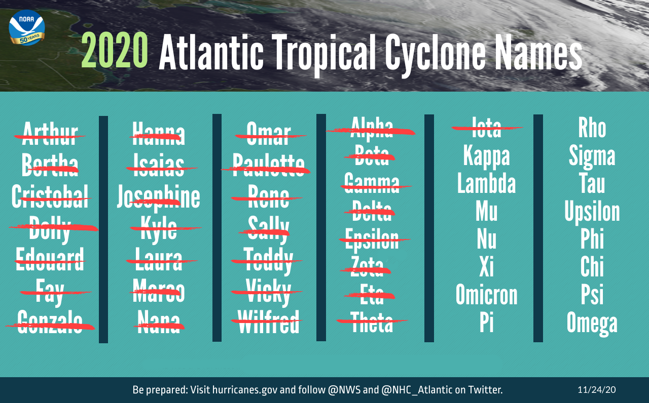 [The list of 30 named storms that have occurred during the 2020 Atlantic Hurricane Season as of November 24, 2020. The 2020 season surpassed 2005 as the busiest on record. The season officially ends November 30. Image from NOAA]
Which is the more challenging aspect of hurricane forecasting—intensity or track—and why?
Intensity forecasting is, by far, the more challenging of the two. This is because hurricane tracks are controlled almost entirely by the larger-scale winds that the storm is embedded in, and we’ve become quite good at predicting these winds out to a few days. Intensity, on the other hand, is controlled by the combined effects of the surrounding environment (for example, is the storm moving into wind shear or colder water), and complex processes occurring within the storm itself. In this respect, the tracks are dictated solely by larger-scale processes that are easier to predict, but intensity is dictated by both large-scale and small-scale processes. The small-scale processes are much harder to predict and many numerical forecast models simply don’t resolve them well. Despite the challenges, there have been substantial improvements to both track and intensity forecasting in the Atlantic over the past 30 years. Average track errors for the 48-hour forecasts have been greatly reduced from about 230 miles in 1990 to about 58 miles in 2019. Average intensity errors for the 48-hour forecasts have been reduced from about 20 mph in 1990 to about 14 mph in 2019. Much of these improvements are due to progress under NOAA’s Hurricane Forecast Improvement Project, which was established in 2008.
How challenging is it to accurately predict rapid intensification in hurricanes?
Very challenging. There are a few reasons for this. Forecasters use a combination of statistical models and numerical models to predict hurricane intensification. The statistical models perform best when the intensification rates aren’t too far from average. In other words, they tend to have trouble predicting extreme intensification. Numerical models tend to struggle with rapid intensification prediction mostly because they have trouble resolving the small-scale processes occurring within the hurricane eye and eyewall, which is where the process of rapid intensification generally begins.
[The list of 30 named storms that have occurred during the 2020 Atlantic Hurricane Season as of November 24, 2020. The 2020 season surpassed 2005 as the busiest on record. The season officially ends November 30. Image from NOAA]
Which is the more challenging aspect of hurricane forecasting—intensity or track—and why?
Intensity forecasting is, by far, the more challenging of the two. This is because hurricane tracks are controlled almost entirely by the larger-scale winds that the storm is embedded in, and we’ve become quite good at predicting these winds out to a few days. Intensity, on the other hand, is controlled by the combined effects of the surrounding environment (for example, is the storm moving into wind shear or colder water), and complex processes occurring within the storm itself. In this respect, the tracks are dictated solely by larger-scale processes that are easier to predict, but intensity is dictated by both large-scale and small-scale processes. The small-scale processes are much harder to predict and many numerical forecast models simply don’t resolve them well. Despite the challenges, there have been substantial improvements to both track and intensity forecasting in the Atlantic over the past 30 years. Average track errors for the 48-hour forecasts have been greatly reduced from about 230 miles in 1990 to about 58 miles in 2019. Average intensity errors for the 48-hour forecasts have been reduced from about 20 mph in 1990 to about 14 mph in 2019. Much of these improvements are due to progress under NOAA’s Hurricane Forecast Improvement Project, which was established in 2008.
How challenging is it to accurately predict rapid intensification in hurricanes?
Very challenging. There are a few reasons for this. Forecasters use a combination of statistical models and numerical models to predict hurricane intensification. The statistical models perform best when the intensification rates aren’t too far from average. In other words, they tend to have trouble predicting extreme intensification. Numerical models tend to struggle with rapid intensification prediction mostly because they have trouble resolving the small-scale processes occurring within the hurricane eye and eyewall, which is where the process of rapid intensification generally begins.
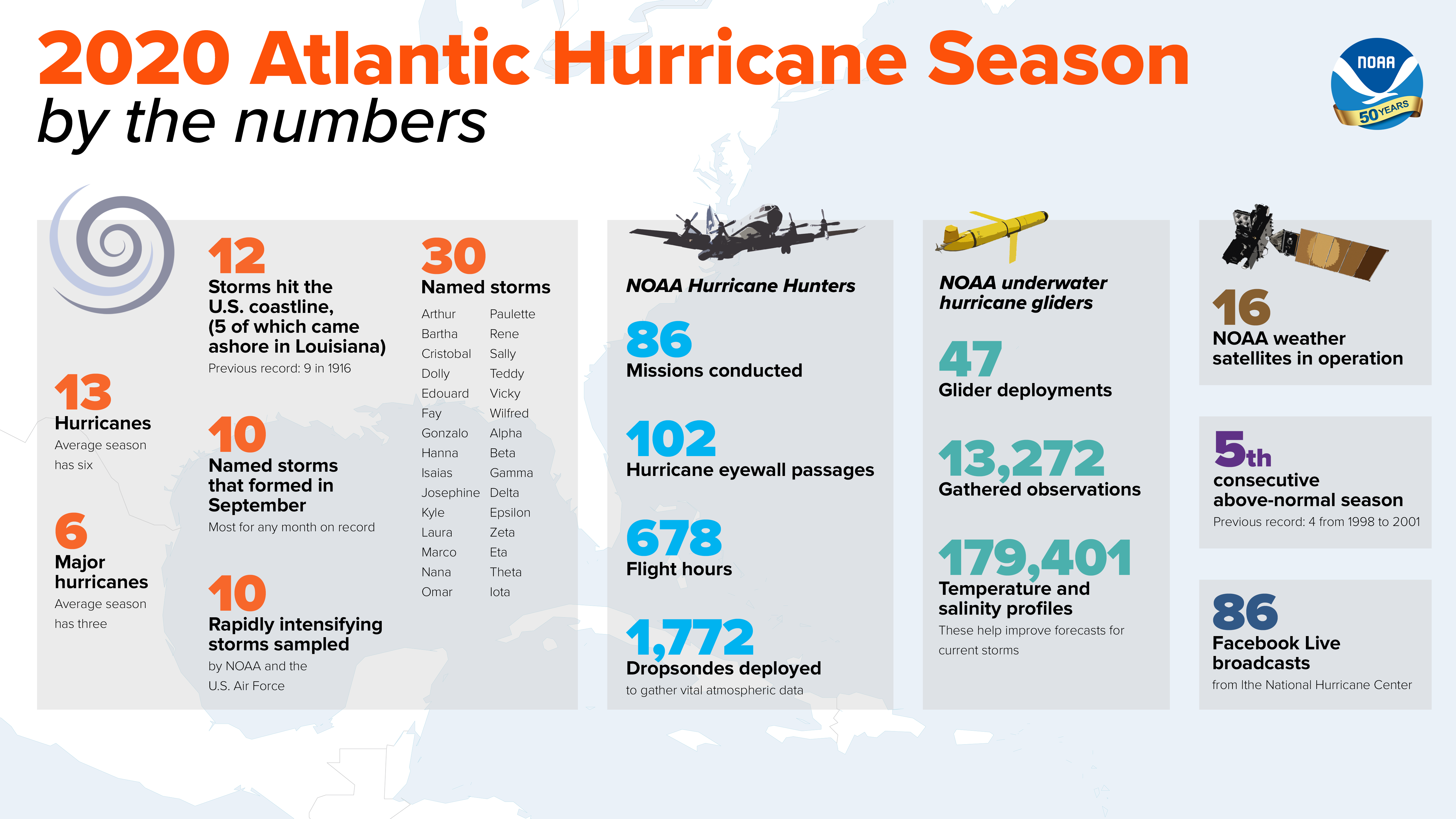 [This infographic highlights key facts and statistics from the 2020 Atlantic Hurricane Season (at the time of publishing on November 24). The Atlantic hurricane season officially ends November 30, but storm activity in the tropics can sometimes continue beyond that date. Image from NOAA]
How crucial are data from NOAA’s advanced satellites for improving hurricane research?
They are absolutely essential. Data from NOAA’s advanced satellites are used in many ways to improve hurricane forecasting and research. For forecasting, the data are assimilated into numerical forecast models, which substantially improves model performance. Satellite data are used to estimate hurricane intensity and location during periods when there are no aircraft flying directly into the hurricanes. Satellite data are used to forecast rapid intensification events as well as eyewall replacement events, which tend to cause large hurricane intensity and size changes. These are just a few examples.
What does the latest research indicate about Atlantic-based hurricanes getting stronger and intensifying quickly?
The evidence continues to mount that hurricane behavior has changed over the past decades, and even the past century, and will continue to change over the next century as the climate continues to change. Globally, tropical cyclones are about 25% more likely to be at major-hurricane intensity now than four decades ago, which is the extent of the most reliable intensity data. Hurricanes are more likely to rapidly intensify and they are more likely to move forward more slowly and stall more often over land. Over the United States, hurricane forward speed has decreased more than 15% since 1900 (120 years), which increases local rainfall flooding substantially. The chances of rapid intensification in the 1980s was about 1 in 100 in the Atlantic. Nowadays the chances are 1 in 20, which is a factor of 5 increase.
More about our expert
In addition to his role at NOAA's NCEI, Jim Kossin also serves as an Honorary Research Fellow at the NOAA Cooperative Institute for Meteorological Satellite Studies and as an Adjunct Faculty Member in the Department of Atmospheric and Oceanic Sciences at the University of Wisconsin-Madison. He is also an Affiliate Member in the Center for Climatic Research, which is part of the Nelson Institute for Environmental Studies.
Edited for WeatherNation by Mace Michaels
[This infographic highlights key facts and statistics from the 2020 Atlantic Hurricane Season (at the time of publishing on November 24). The Atlantic hurricane season officially ends November 30, but storm activity in the tropics can sometimes continue beyond that date. Image from NOAA]
How crucial are data from NOAA’s advanced satellites for improving hurricane research?
They are absolutely essential. Data from NOAA’s advanced satellites are used in many ways to improve hurricane forecasting and research. For forecasting, the data are assimilated into numerical forecast models, which substantially improves model performance. Satellite data are used to estimate hurricane intensity and location during periods when there are no aircraft flying directly into the hurricanes. Satellite data are used to forecast rapid intensification events as well as eyewall replacement events, which tend to cause large hurricane intensity and size changes. These are just a few examples.
What does the latest research indicate about Atlantic-based hurricanes getting stronger and intensifying quickly?
The evidence continues to mount that hurricane behavior has changed over the past decades, and even the past century, and will continue to change over the next century as the climate continues to change. Globally, tropical cyclones are about 25% more likely to be at major-hurricane intensity now than four decades ago, which is the extent of the most reliable intensity data. Hurricanes are more likely to rapidly intensify and they are more likely to move forward more slowly and stall more often over land. Over the United States, hurricane forward speed has decreased more than 15% since 1900 (120 years), which increases local rainfall flooding substantially. The chances of rapid intensification in the 1980s was about 1 in 100 in the Atlantic. Nowadays the chances are 1 in 20, which is a factor of 5 increase.
More about our expert
In addition to his role at NOAA's NCEI, Jim Kossin also serves as an Honorary Research Fellow at the NOAA Cooperative Institute for Meteorological Satellite Studies and as an Adjunct Faculty Member in the Department of Atmospheric and Oceanic Sciences at the University of Wisconsin-Madison. He is also an Affiliate Member in the Center for Climatic Research, which is part of the Nelson Institute for Environmental Studies.
Edited for WeatherNation by Mace Michaels
[Jim Kossin, NOAA NCEI. Photo credit: Space Science and Engineering Center/Greg Anderson Photography]
What are the reasons some of this year’s storms intensified so quickly? Are we seeing more of these types of storms occurring overall?
The main culprit for the hyper-activity this year was warmer-than-average ocean temperatures. This is also the main reason for the longer-than-average season and the numerous rapid-intensification events. The frequency of rapid-intensification events has increased over the past four decades, and this increase has been linked to climate change. The length of the hurricane season increases by about 40 days per degree Celsius of warming (the season starts about 20 days earlier and lasts about 20 days longer, on average). But the link to climate change for this is not as clear because our understanding of how and why hurricanes form is not as strong as our understanding of how and why hurricanes intensify.
Based on the changing climate, will the hurricane season need to officially start earlier than June 1?
This is a bit tricky. The relationship between global warming and tropical storm formation is less clear than, for example, the relationship between global warming and intensity. There is good consensus that global warming increases intensity, but no strong consensus that warming increases frequency. If there is no clear expectation that global warming increases tropical storm frequency, then there should be no clear expectation that the season will lengthen under global warming. This may seem a bit counterintuitive since the length of the season is influenced by ocean temperatures, as noted just above, and ocean temperatures are influenced by global warming. But this is where things get more complicated. The way that tropical storm formation responds to warming oceans depends strongly on what it was that warmed the ocean. Global warming from greenhouse gases tends to warm the tropics somewhat uniformly and this type of warming is not expected to increase frequency. Regional warming from things like reduced pollution or Saharan dust over the Atlantic ocean does increase frequency. So, in this case, the increased frequency we’ve observed in the Atlantic since around the mid-1990s is most likely due to these regional effects and not so much due to global warming. And if this is true, then we don’t necessarily expect Atlantic storm frequency to continue to increase due to continued global warming. This is one of the frontier research problems that we’re trying to understand better.
[The list of 30 named storms that have occurred during the 2020 Atlantic Hurricane Season as of November 24, 2020. The 2020 season surpassed 2005 as the busiest on record. The season officially ends November 30. Image from NOAA]
Which is the more challenging aspect of hurricane forecasting—intensity or track—and why?
Intensity forecasting is, by far, the more challenging of the two. This is because hurricane tracks are controlled almost entirely by the larger-scale winds that the storm is embedded in, and we’ve become quite good at predicting these winds out to a few days. Intensity, on the other hand, is controlled by the combined effects of the surrounding environment (for example, is the storm moving into wind shear or colder water), and complex processes occurring within the storm itself. In this respect, the tracks are dictated solely by larger-scale processes that are easier to predict, but intensity is dictated by both large-scale and small-scale processes. The small-scale processes are much harder to predict and many numerical forecast models simply don’t resolve them well. Despite the challenges, there have been substantial improvements to both track and intensity forecasting in the Atlantic over the past 30 years. Average track errors for the 48-hour forecasts have been greatly reduced from about 230 miles in 1990 to about 58 miles in 2019. Average intensity errors for the 48-hour forecasts have been reduced from about 20 mph in 1990 to about 14 mph in 2019. Much of these improvements are due to progress under NOAA’s Hurricane Forecast Improvement Project, which was established in 2008.
How challenging is it to accurately predict rapid intensification in hurricanes?
Very challenging. There are a few reasons for this. Forecasters use a combination of statistical models and numerical models to predict hurricane intensification. The statistical models perform best when the intensification rates aren’t too far from average. In other words, they tend to have trouble predicting extreme intensification. Numerical models tend to struggle with rapid intensification prediction mostly because they have trouble resolving the small-scale processes occurring within the hurricane eye and eyewall, which is where the process of rapid intensification generally begins.
[This infographic highlights key facts and statistics from the 2020 Atlantic Hurricane Season (at the time of publishing on November 24). The Atlantic hurricane season officially ends November 30, but storm activity in the tropics can sometimes continue beyond that date. Image from NOAA]
How crucial are data from NOAA’s advanced satellites for improving hurricane research?
They are absolutely essential. Data from NOAA’s advanced satellites are used in many ways to improve hurricane forecasting and research. For forecasting, the data are assimilated into numerical forecast models, which substantially improves model performance. Satellite data are used to estimate hurricane intensity and location during periods when there are no aircraft flying directly into the hurricanes. Satellite data are used to forecast rapid intensification events as well as eyewall replacement events, which tend to cause large hurricane intensity and size changes. These are just a few examples.
What does the latest research indicate about Atlantic-based hurricanes getting stronger and intensifying quickly?
The evidence continues to mount that hurricane behavior has changed over the past decades, and even the past century, and will continue to change over the next century as the climate continues to change. Globally, tropical cyclones are about 25% more likely to be at major-hurricane intensity now than four decades ago, which is the extent of the most reliable intensity data. Hurricanes are more likely to rapidly intensify and they are more likely to move forward more slowly and stall more often over land. Over the United States, hurricane forward speed has decreased more than 15% since 1900 (120 years), which increases local rainfall flooding substantially. The chances of rapid intensification in the 1980s was about 1 in 100 in the Atlantic. Nowadays the chances are 1 in 20, which is a factor of 5 increase.
More about our expert
In addition to his role at NOAA's NCEI, Jim Kossin also serves as an Honorary Research Fellow at the NOAA Cooperative Institute for Meteorological Satellite Studies and as an Adjunct Faculty Member in the Department of Atmospheric and Oceanic Sciences at the University of Wisconsin-Madison. He is also an Affiliate Member in the Center for Climatic Research, which is part of the Nelson Institute for Environmental Studies.
Edited for WeatherNation by Mace MichaelsAll Weather News
More
Storms Return From the Front Range to Texas
Moisture is moving back into the Central and
10 Jul 2025 10:45 PM

Medium Range Tropics Forecast Favors Gulf, CSU Updates Seasonal Forecast
While the Atlantic appears quiet, conditions
10 Jul 2025 10:40 PM

Severe Thunderstorms Expected Across the East Coast
The severe weather and flood threat continues
10 Jul 2025 10:30 PM

Rounds of Severe Storms to Impact Great Plains and Midwest Through the Weekend
A dynamic summer weather pattern is setting t
10 Jul 2025 10:25 PM

Timeline: How Catastrophic Flooding Unfolded in Texas Hill Country
TEXAS - Catastrophic flooding devastated port
10 Jul 2025 10:00 AM

Ruidoso Flash Flooding - Record Crest for the Rio Ruidoso River
A slow-moving monsoonal thunderstorm develope
10 Jul 2025 1:55 AM
