Deadly storm brings hurricane force winds, coastal flooding, snow to Northeast
Special Stories
2 Mar 2018 2:32 PM
This storm is definitely one for the record books. After reaching official bombogenesis status Friday morning, the storm continues to pound the Northeast into the evening.
As of Friday evening, there were more than 1.6 million power outages reported across the eastern U.S., and at least five deaths related to the storm.
This video shows the coastal flooding seen in Marshfield, Massachusetts Friday afternoon.
https://www.facebook.com/WeatherNation/videos/10156298875529874/
During high tide, water flooded Nantucket, Massachusetts streets. This was the view from Nantucket Friday morning.
https://www.facebook.com/WeatherNation/videos/10156299222544874/
And about 70 miles to the north of Nantucket island, the scene isn't much different. The street is barely visible due to the floodwater.
https://twitter.com/WeatherNation/status/969678388616036352
Not only is coastal flooding an issue for the coast, but the winds recorded have reached hurricane strength. A Category 1 Hurricane has winds of at least 74 miles per hour.
https://twitter.com/WeatherNation/status/969677824557662208
Check out some of these statistics from this storm:
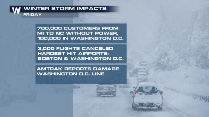 Rain, snow, high winds, and coastal flooding are causing power outages and travel disruptions. Even train service is being affected.
The National Weather Service in Boston said that it recorded its third highest crest on record Friday morning as the Nor'easter slammed the city. The tide is expected to be even higher Friday night.
https://twitter.com/WeatherNation/status/969662532817379328
And about 70 miles to the north of Nantucket island, the scene isn't much different. The street is barely visible due to the floodwater.
https://twitter.com/WeatherNation/status/969678388616036352
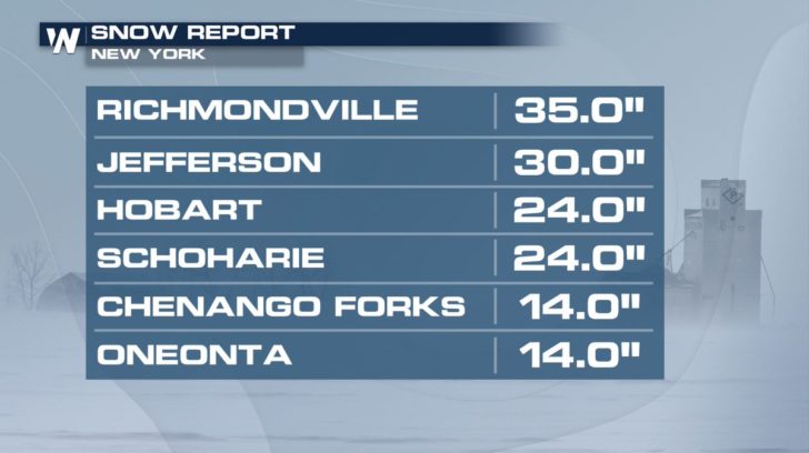
And if coastal flooding and hurricane force winds weren't enough, check out some of the latest snowfall reports from New York. As of Friday evening, they were quickly approaching THREE FEET of snow!
Rain, snow, high winds, and coastal flooding are causing power outages and travel disruptions. Even train service is being affected.
The National Weather Service in Boston said that it recorded its third highest crest on record Friday morning as the Nor'easter slammed the city. The tide is expected to be even higher Friday night.
https://twitter.com/WeatherNation/status/969662532817379328
And about 70 miles to the north of Nantucket island, the scene isn't much different. The street is barely visible due to the floodwater.
https://twitter.com/WeatherNation/status/969678388616036352
And if coastal flooding and hurricane force winds weren't enough, check out some of the latest snowfall reports from New York. As of Friday evening, they were quickly approaching THREE FEET of snow!
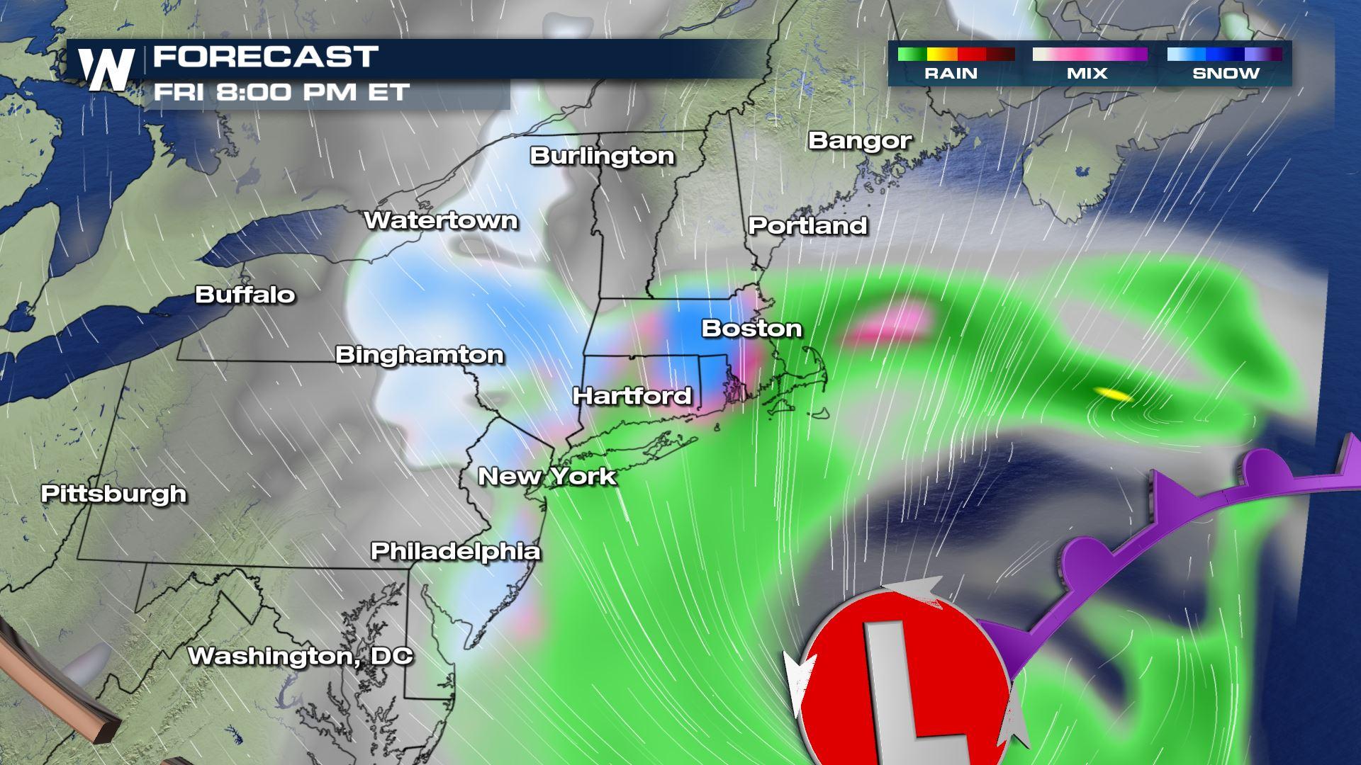
 The Nor'easter will continue to be very strong but gradually pull away by Saturday. This video shows the hour-by-hour forecast through Saturday afternoon. Note that the rain and snow will continue until at least midnight for many locations, ending by dawn. However, the winds will stay very strong through most of Saturday.
https://www.facebook.com/WeatherNation/videos/10156299292914874/
The Nor'easter will continue to be very strong but gradually pull away by Saturday. This video shows the hour-by-hour forecast through Saturday afternoon. Note that the rain and snow will continue until at least midnight for many locations, ending by dawn. However, the winds will stay very strong through most of Saturday.
https://www.facebook.com/WeatherNation/videos/10156299292914874/
Rain, snow, high winds, and coastal flooding are causing power outages and travel disruptions. Even train service is being affected.
The National Weather Service in Boston said that it recorded its third highest crest on record Friday morning as the Nor'easter slammed the city. The tide is expected to be even higher Friday night.
https://twitter.com/WeatherNation/status/969662532817379328
And about 70 miles to the north of Nantucket island, the scene isn't much different. The street is barely visible due to the floodwater.
https://twitter.com/WeatherNation/status/969678388616036352
And if coastal flooding and hurricane force winds weren't enough, check out some of the latest snowfall reports from New York. As of Friday evening, they were quickly approaching THREE FEET of snow!
The Nor'easter will continue to be very strong but gradually pull away by Saturday. This video shows the hour-by-hour forecast through Saturday afternoon. Note that the rain and snow will continue until at least midnight for many locations, ending by dawn. However, the winds will stay very strong through most of Saturday.
https://www.facebook.com/WeatherNation/videos/10156299292914874/All Weather News
More
Wildfire Outbreak in the Pacific Northwest
SPOKANE, WA - On Saturday, August 1st, the Ol
3 Aug 2026 1:55 AM

More Storms for the East Through Monday
A low-pressure system that moved through the
3 Aug 2026 1:50 AM


After Reaching Category 5, Genevieve Weakens in the Pacific
PacificGenevieve formed last Friday south of
3 Aug 2026 12:30 AM

Flooding, Severe Storms Target the Midwest Again
After an active week of storms across the nor
1 Aug 2026 1:40 AM

Flooding Risk Increases as Heavy Rain Targets the Tri-State Area
Tuesday, heavy rainfall moved across the Nort
30 Jul 2026 12:25 AM

Severe Weather: Energy From the Midwest Now in the Southeast
UPPER MIDWEST - Through Monday, dangerous tor
29 Jul 2026 10:30 PM