Two Disturbances in the Eastern Pacific Have a Chance of Developing

It's Hurricane Prep Week on WeatherNation for the first week of the Atlantic Hurricane season!
Eastern Pacific Becomes Focus of Early Hurricane Season Activity:
While the Atlantic Basin remains quiet to start the 2026 hurricane season, forecasters are closely monitoring growing activity across the Eastern Pacific. The National Hurricane Center is tracking Tropical Storm Amanda along with two additional disturbances that could develop in the coming days, making the Pacific the most active tropical basin in the Northern Hemisphere right now. ( See Above Image)
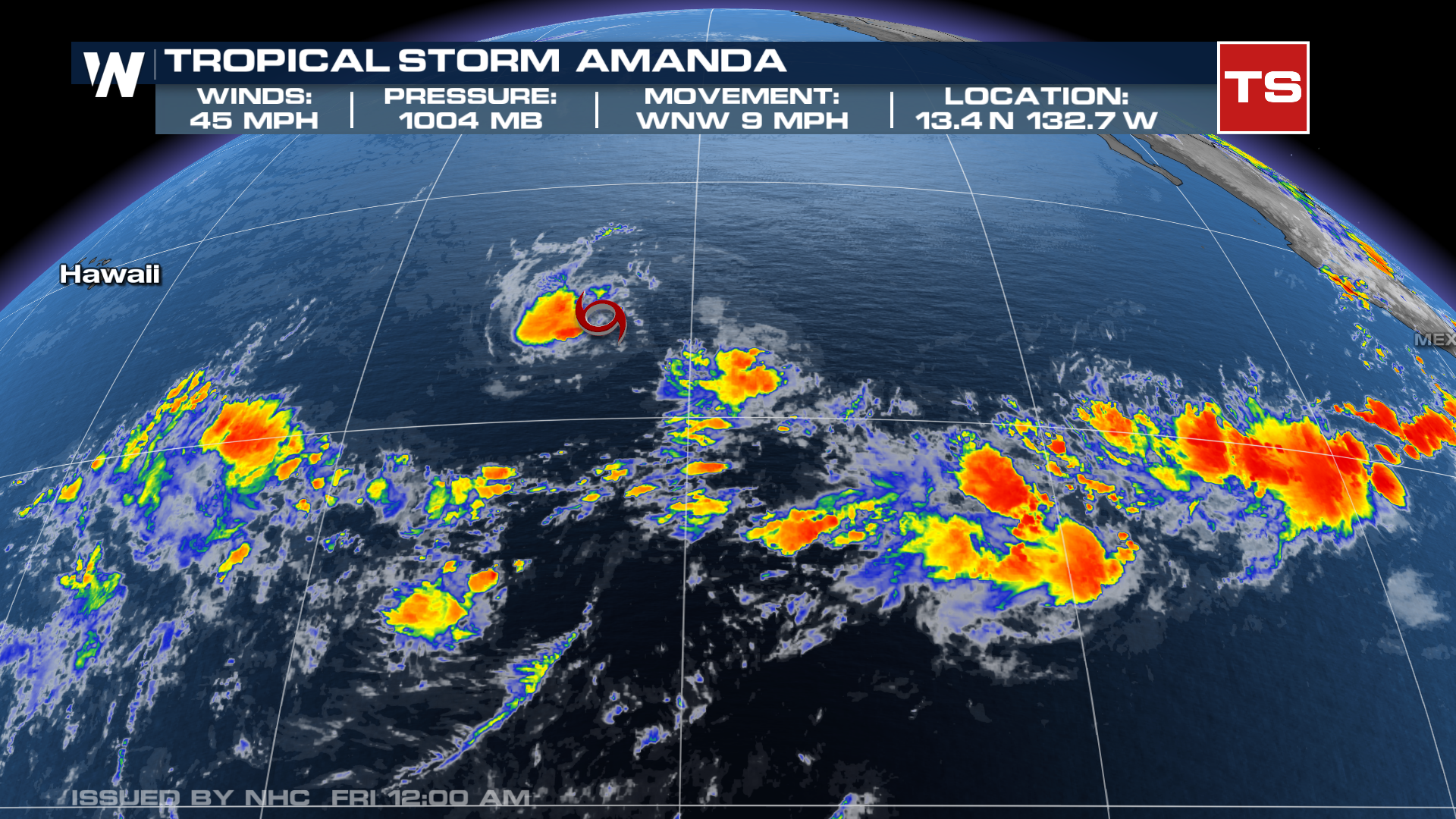
Amanda Becomes First Named Storm of the Season:
Tropical Storm Amanda formed on Wednesday, becoming the first named storm of the 2026 Eastern Pacific hurricane season. The storm is currently located well away from land and is not expected to threaten any coastal areas. Amanda is producing sustained winds of around 45 mph as it moves west-northwest over open waters. Forecasters expect some additional strengthening before the storm encounters cooler ocean temperatures and less favorable atmospheric conditions later this week, leading to gradual weakening.
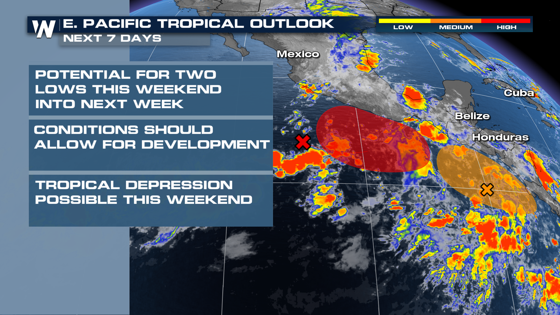
Two Disturbances Could Bring Additional Development:
In addition to Amanda, meteorologists are watching two separate areas of disturbed weather south and southwest of Mexico. Both systems currently have medium to high odds of tropical development over the next several days as they move over warm waters conducive to tropical cyclone formation. Some impacts on portions of Mexico are possible if either system strengthens and tracks closer to the coastline.
The National Hurricane Center continues to monitor these disturbances closely, and future outlooks could increase or decrease development chances depending on how environmental conditions evolve.
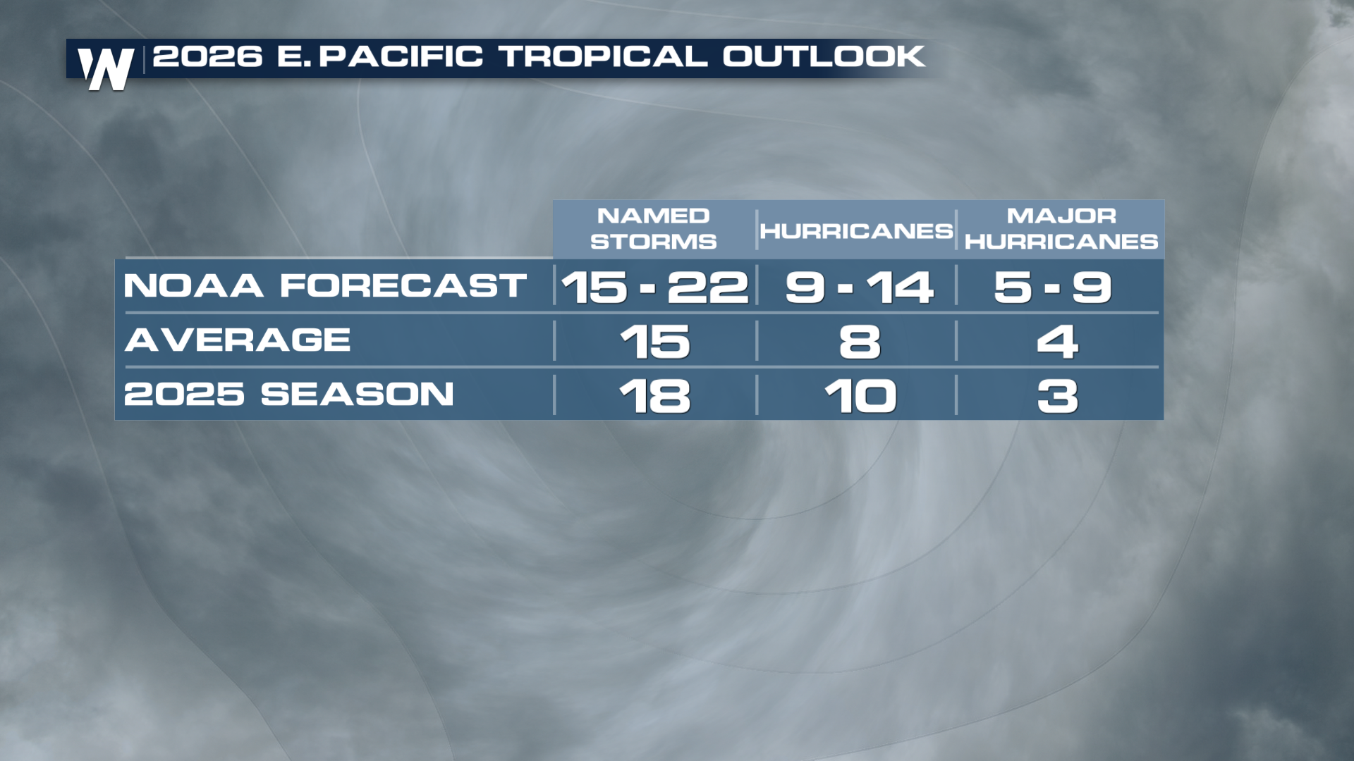
Signs Point to an Active Eastern Pacific Season:
The early burst of activity is occurring as sea surface temperatures across parts of the Eastern Pacific remain warmer than average. Combined with the development of El Niño conditions, forecasters expect the basin to remain favorable for tropical cyclone formation through much of the season. NOAA’s seasonal outlook calls for an above-average Eastern Pacific hurricane season, with between 15 and 22 named storms possible. Several of those storms could reach hurricane strength, including multiple major hurricanes.
Meanwhile, the Atlantic Basin is off to a slow start, with dry air associated with Saharan dust helping suppress tropical development across much of the region. While quiet conditions are expected to continue in the near term, the Eastern Pacific is already showing signs that the 2026 tropical season could be an active one.
Atlantic
The Atlantic is starting the season with no activity expected through the first week. A big burst of Saharan Dust is providing plenty of dry air, which could impact air quality and visibility in the Caribbean and parts of Florida through the week ahead.
Stay With WeatherNation This Hurricane Season:
Whether storms threaten land or remain over open waters, WeatherNation is your destination for around-the-clock tropical coverage. Our meteorologists track every tropical wave, depression, storm, and hurricane with the latest forecast models, expert analysis, and live updates whenever conditions warrant.


