Water Rescues From Flooding Saturday Night
Special Stories
10 Feb 2018 9:12 PM
Late Saturday night several storm reports noted the heavy rainfall, flooded roadways, and even water rescues across the Eastern United States.
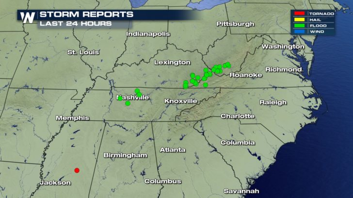 Severe weather reports between late Friday night and late Saturday night, where the green dots show all of the separate reports for flooding.
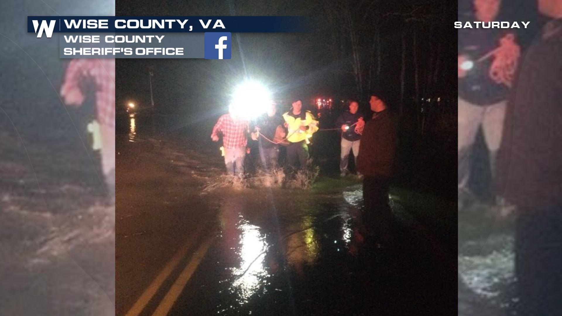
Here is one report of a water rescue from Wise County, Virginia around 10 o'clock local time Saturday night:
"WATER RESCUE IN POWELL VALLEY SECTION OF WISE COUNTY. SUBJECT ATTEMPTED TO DRIVE THROUGH A FLOODED ROADWAY AND
THE WATER PUSHED THE VEHICLE INTO THE RIVER. NO INJURIES."
Severe weather reports between late Friday night and late Saturday night, where the green dots show all of the separate reports for flooding.
Here is one report of a water rescue from Wise County, Virginia around 10 o'clock local time Saturday night:
"WATER RESCUE IN POWELL VALLEY SECTION OF WISE COUNTY. SUBJECT ATTEMPTED TO DRIVE THROUGH A FLOODED ROADWAY AND
THE WATER PUSHED THE VEHICLE INTO THE RIVER. NO INJURIES."
 Another storm report from Mississippi (about four miles east of Starkville) read the following...
"NUMEROUS REPORTS OF STREET FLOODING AT THE HIGHLANDS WITH SOME HOMES BEING THREATENED BY FLOODWATERS.
THE WATER HAS SUBSIDED IN THE PAST HALF HOUR. "
https://twitter.com/WeatherNation/status/962544880642752512
Flood alerts continue into Sunday in anticipation for the high water and heavy rainfall.
Another storm report from Mississippi (about four miles east of Starkville) read the following...
"NUMEROUS REPORTS OF STREET FLOODING AT THE HIGHLANDS WITH SOME HOMES BEING THREATENED BY FLOODWATERS.
THE WATER HAS SUBSIDED IN THE PAST HALF HOUR. "
https://twitter.com/WeatherNation/status/962544880642752512
Flood alerts continue into Sunday in anticipation for the high water and heavy rainfall.
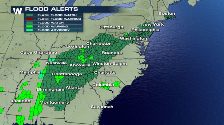 Flood alerts late Saturday night showed the areas of observed high water (bright green) and anticipated high water (darker green). These alerts last through at least Sunday if not through early this week.
Already, rain gauges have picked up between 1 and 2 inches in many spots.
Flood alerts late Saturday night showed the areas of observed high water (bright green) and anticipated high water (darker green). These alerts last through at least Sunday if not through early this week.
Already, rain gauges have picked up between 1 and 2 inches in many spots.
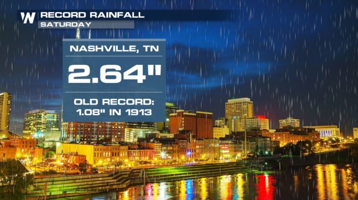
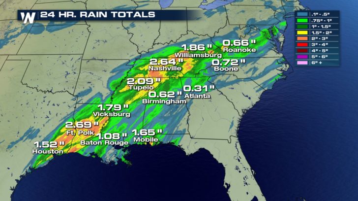 The 24-hour rainfall report ending around 9 p.m. central 10 p.m. eastern Saturday, February 10.
In fact Nashville, Tennessee broke a daily rainfall record with at least 2.64" of rain as of 9 p.m. central Saturday.
The 24-hour rainfall report ending around 9 p.m. central 10 p.m. eastern Saturday, February 10.
In fact Nashville, Tennessee broke a daily rainfall record with at least 2.64" of rain as of 9 p.m. central Saturday.
 More heavy rain is on the way for this area. We have written more extensively about it in previous stories. Check out Josh Cozart's Coast-to-Coast Storm Forecast and Matt Monroe's Severe Weather Threat for the Southeast.
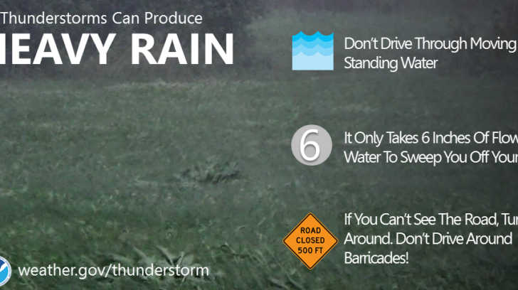
Remember, it does not take a lot of water to sweep a person off their feet, or even sweep a car down the road. Avoid high water and don't drive through flooded roads.
More heavy rain is on the way for this area. We have written more extensively about it in previous stories. Check out Josh Cozart's Coast-to-Coast Storm Forecast and Matt Monroe's Severe Weather Threat for the Southeast.
Remember, it does not take a lot of water to sweep a person off their feet, or even sweep a car down the road. Avoid high water and don't drive through flooded roads.
 Courtesy NOAA/NWS
For WeatherNation, Meteorologist Steve Glazier
Courtesy NOAA/NWS
For WeatherNation, Meteorologist Steve Glazier
Severe weather reports between late Friday night and late Saturday night, where the green dots show all of the separate reports for flooding.
Here is one report of a water rescue from Wise County, Virginia around 10 o'clock local time Saturday night:
"WATER RESCUE IN POWELL VALLEY SECTION OF WISE COUNTY. SUBJECT ATTEMPTED TO DRIVE THROUGH A FLOODED ROADWAY AND
THE WATER PUSHED THE VEHICLE INTO THE RIVER. NO INJURIES."
Another storm report from Mississippi (about four miles east of Starkville) read the following...
"NUMEROUS REPORTS OF STREET FLOODING AT THE HIGHLANDS WITH SOME HOMES BEING THREATENED BY FLOODWATERS.
THE WATER HAS SUBSIDED IN THE PAST HALF HOUR. "
https://twitter.com/WeatherNation/status/962544880642752512
Flood alerts continue into Sunday in anticipation for the high water and heavy rainfall.
Flood alerts late Saturday night showed the areas of observed high water (bright green) and anticipated high water (darker green). These alerts last through at least Sunday if not through early this week.
Already, rain gauges have picked up between 1 and 2 inches in many spots.
The 24-hour rainfall report ending around 9 p.m. central 10 p.m. eastern Saturday, February 10.
In fact Nashville, Tennessee broke a daily rainfall record with at least 2.64" of rain as of 9 p.m. central Saturday.
More heavy rain is on the way for this area. We have written more extensively about it in previous stories. Check out Josh Cozart's Coast-to-Coast Storm Forecast and Matt Monroe's Severe Weather Threat for the Southeast.
Remember, it does not take a lot of water to sweep a person off their feet, or even sweep a car down the road. Avoid high water and don't drive through flooded roads.
Courtesy NOAA/NWS
For WeatherNation, Meteorologist Steve GlazierAll Weather News
More


More Storms for the East Through Monday
A low-pressure system that moved through the
3 Aug 2026 1:50 AM

After Reaching Category 5, Genevieve Weakens in the Pacific
PacificGenevieve formed last Friday south of
3 Aug 2026 12:30 AM

Flooding, Severe Storms Target the Midwest Again
After an active week of storms across the nor
1 Aug 2026 1:40 AM

Flooding Risk Increases as Heavy Rain Targets the Tri-State Area
Tuesday, heavy rainfall moved across the Nort
30 Jul 2026 12:25 AM

Severe Weather: Energy From the Midwest Now in the Southeast
UPPER MIDWEST - Through Monday, dangerous tor
29 Jul 2026 10:30 PM