Water Rescues Reported in Des Moines Amid Flood Emergency
Top Stories
30 Jun 2018 10:13 PM
Late Saturday heavy thunderstorms continued to roll across parts of the Plains and Midwest, especially Iowa. Numerous reports of water rescues were reported in the Des Moines metro area according to Polk County Emergency Management.
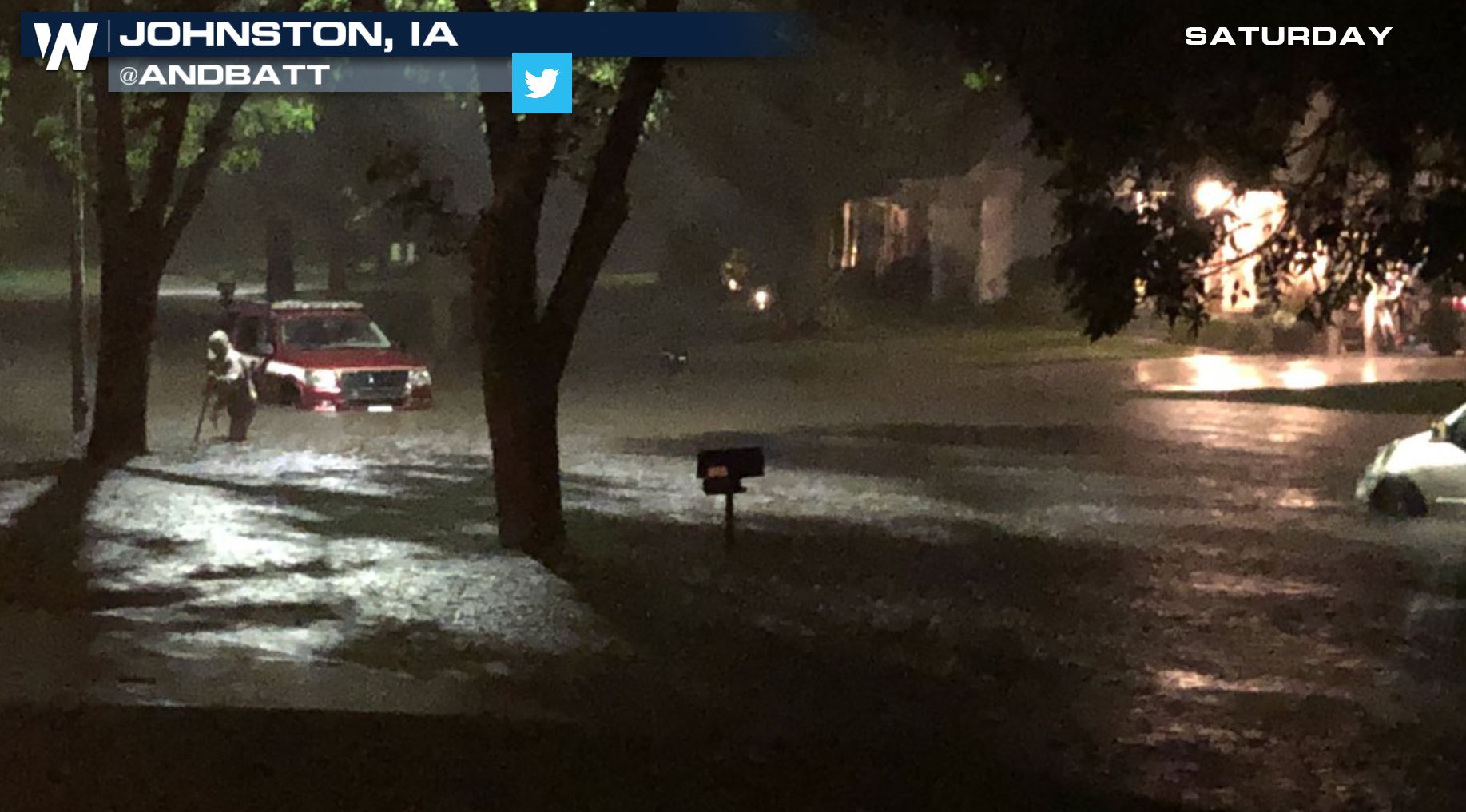 Flooding in Johnston, Iowa courtesy Twitter user @AndBatt
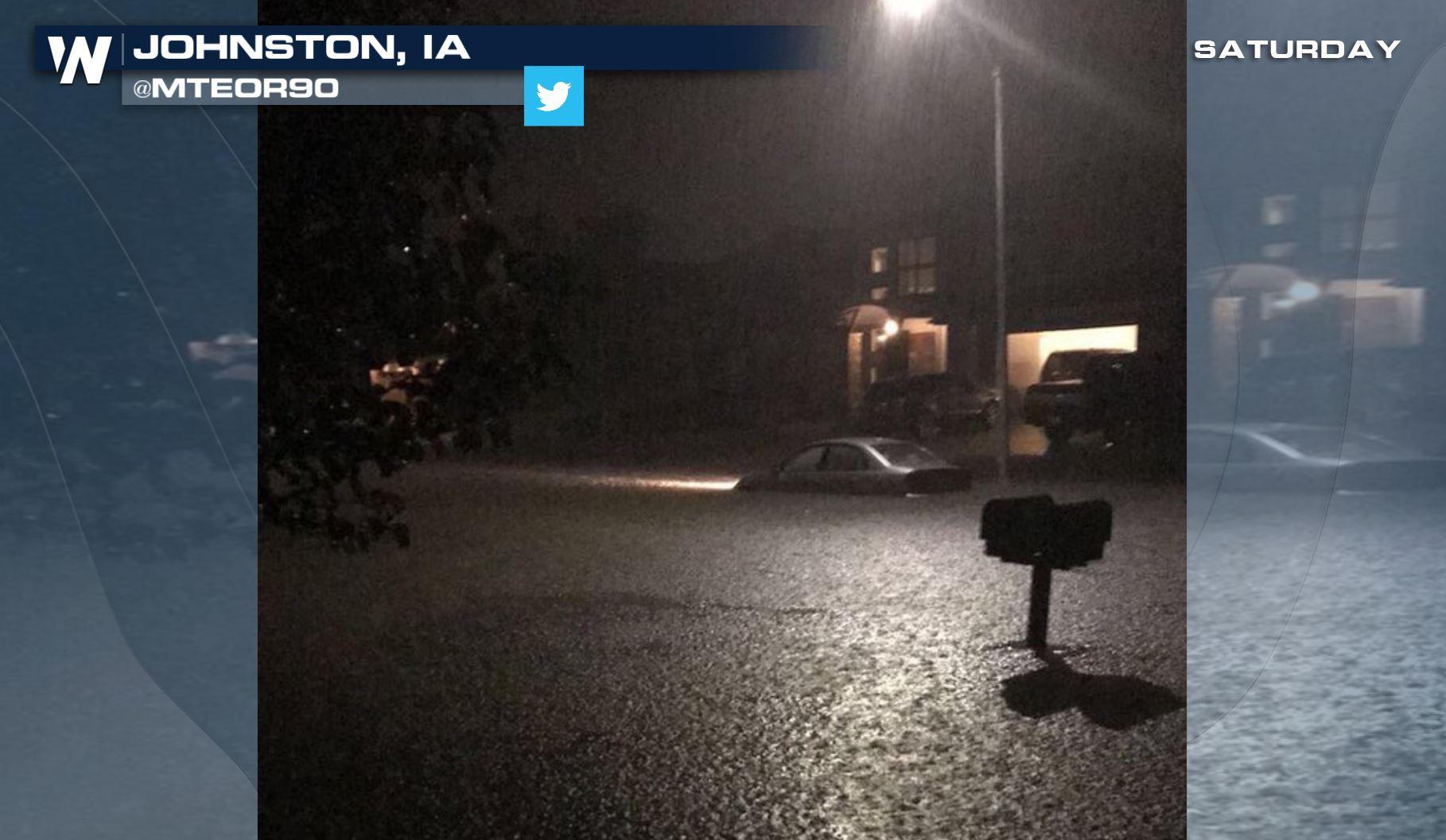
 Flooding in Johnston, Iowa courtesy Twitter user @Mteor90
https://www.facebook.com/WeatherNation/videos/10156621437404874/
https://twitter.com/WeatherNation/status/1013253286177038336
*Note* The above image/tweet was captured as of about 10 p.m. central Saturday, June 30.
Since this is an ever-changing story, we encourage the following sources for a means of information. For local weather information regarding this story, please visit the National Weather Service - Des Moines office either on Twitter here or via Facebook here.
https://twitter.com/NWSDesMoines/status/1013258946755391488
There were multiple reports of flooded roads across the Des Moines area late Saturday. It's important to remember the phrase 'Turn Around, Don't Drown" when it comes to flooded roads. Also unless travel is necessary, it's recommended to stay put and not drive in these conditions, especially at night.
Flooding in Johnston, Iowa courtesy Twitter user @Mteor90
https://www.facebook.com/WeatherNation/videos/10156621437404874/
https://twitter.com/WeatherNation/status/1013253286177038336
*Note* The above image/tweet was captured as of about 10 p.m. central Saturday, June 30.
Since this is an ever-changing story, we encourage the following sources for a means of information. For local weather information regarding this story, please visit the National Weather Service - Des Moines office either on Twitter here or via Facebook here.
https://twitter.com/NWSDesMoines/status/1013258946755391488
There were multiple reports of flooded roads across the Des Moines area late Saturday. It's important to remember the phrase 'Turn Around, Don't Drown" when it comes to flooded roads. Also unless travel is necessary, it's recommended to stay put and not drive in these conditions, especially at night.
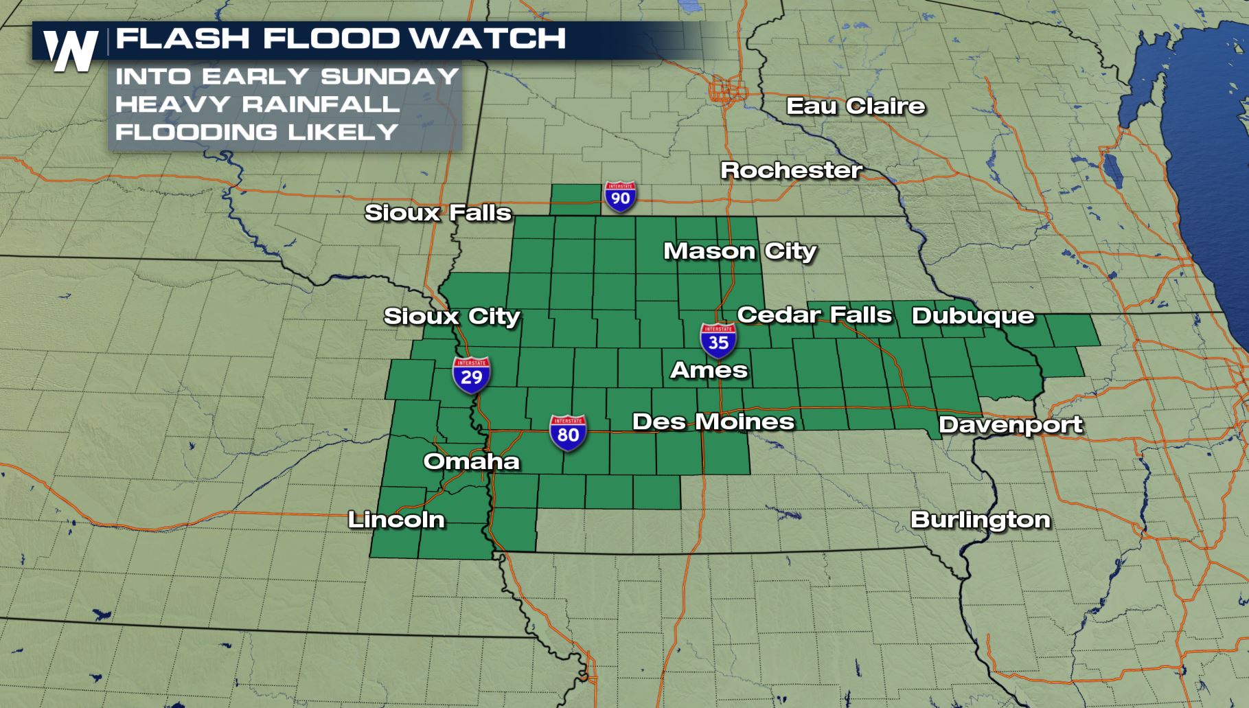 Flash flooding remains likely in these green shaded areas through early Sunday morning, the 1st of July.
The flooding was the result of thunderstorm after thunderstorm across the state.
Flash flooding remains likely in these green shaded areas through early Sunday morning, the 1st of July.
The flooding was the result of thunderstorm after thunderstorm across the state.
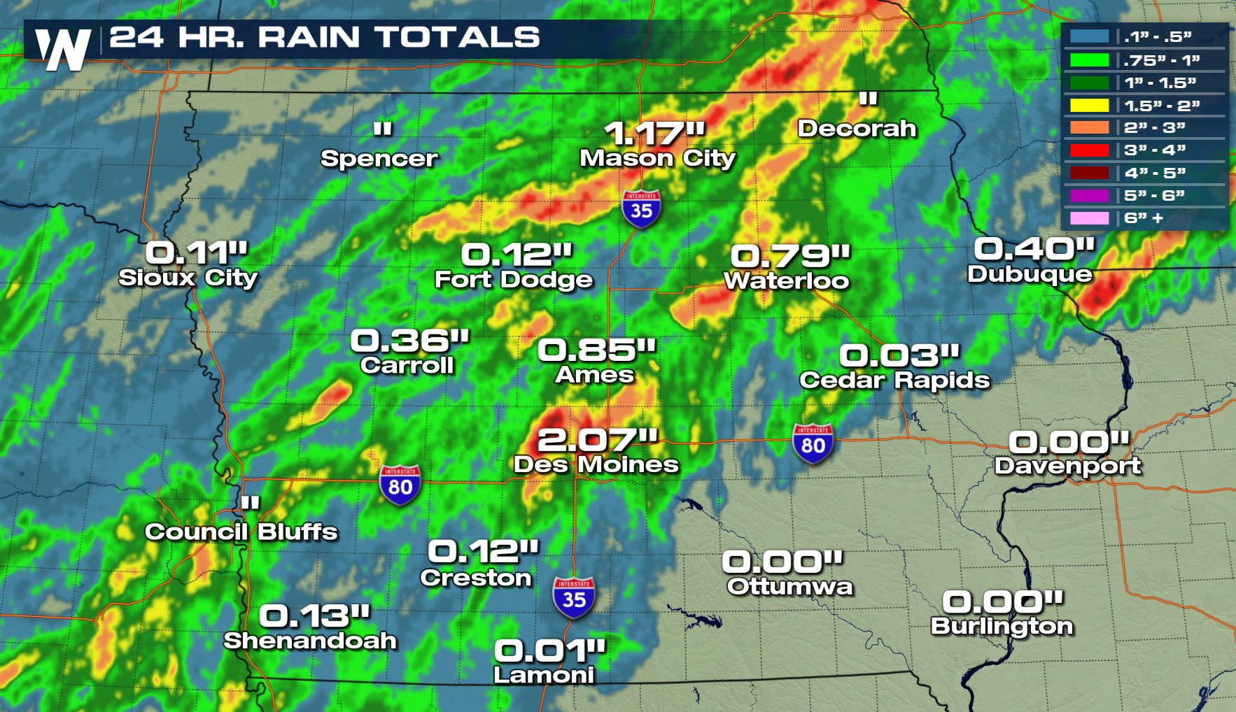 Rainfall totals from the previous 24 hours ending late Saturday, June 30.
These rain gauges caught 1-2" of rainfall, but the select red and maroon colors showed as much as 3-5" of rainfall in a 24-hour period ending late Saturday.
More thunderstorms are expected through at least 3 a.m. local time, even possibly until 7 a.m. Sunday. Please stay weather aware and refer to the links above for additional information into early Sunday.
For WeatherNation, Meteorologist Steve Glazier
Rainfall totals from the previous 24 hours ending late Saturday, June 30.
These rain gauges caught 1-2" of rainfall, but the select red and maroon colors showed as much as 3-5" of rainfall in a 24-hour period ending late Saturday.
More thunderstorms are expected through at least 3 a.m. local time, even possibly until 7 a.m. Sunday. Please stay weather aware and refer to the links above for additional information into early Sunday.
For WeatherNation, Meteorologist Steve Glazier
Flooding in Johnston, Iowa courtesy Twitter user @AndBatt
Flooding in Johnston, Iowa courtesy Twitter user @Mteor90
https://www.facebook.com/WeatherNation/videos/10156621437404874/
https://twitter.com/WeatherNation/status/1013253286177038336
*Note* The above image/tweet was captured as of about 10 p.m. central Saturday, June 30.
Since this is an ever-changing story, we encourage the following sources for a means of information. For local weather information regarding this story, please visit the National Weather Service - Des Moines office either on Twitter here or via Facebook here.
https://twitter.com/NWSDesMoines/status/1013258946755391488
There were multiple reports of flooded roads across the Des Moines area late Saturday. It's important to remember the phrase 'Turn Around, Don't Drown" when it comes to flooded roads. Also unless travel is necessary, it's recommended to stay put and not drive in these conditions, especially at night.
Flash flooding remains likely in these green shaded areas through early Sunday morning, the 1st of July.
The flooding was the result of thunderstorm after thunderstorm across the state.
Rainfall totals from the previous 24 hours ending late Saturday, June 30.
These rain gauges caught 1-2" of rainfall, but the select red and maroon colors showed as much as 3-5" of rainfall in a 24-hour period ending late Saturday.
More thunderstorms are expected through at least 3 a.m. local time, even possibly until 7 a.m. Sunday. Please stay weather aware and refer to the links above for additional information into early Sunday.
For WeatherNation, Meteorologist Steve GlazierAll Weather News
More
Wildfire Outbreak in the Pacific Northwest
SPOKANE, WA - On Saturday, August 1st, the Ol
3 Aug 2026 1:55 AM

More Storms for the East Through Monday
A low-pressure system that moved through the
3 Aug 2026 1:50 AM


After Reaching Category 5, Genevieve Weakens in the Pacific
PacificGenevieve formed last Friday south of
3 Aug 2026 12:30 AM

Flooding, Severe Storms Target the Midwest Again
After an active week of storms across the nor
1 Aug 2026 1:40 AM

Flooding Risk Increases as Heavy Rain Targets the Tri-State Area
Tuesday, heavy rainfall moved across the Nort
30 Jul 2026 12:25 AM

Severe Weather: Energy From the Midwest Now in the Southeast
UPPER MIDWEST - Through Monday, dangerous tor
29 Jul 2026 10:30 PM