Waterspout or Tornado Over Water? The NWS Weighs In...
Special Stories
23 Apr 2018 3:27 PM
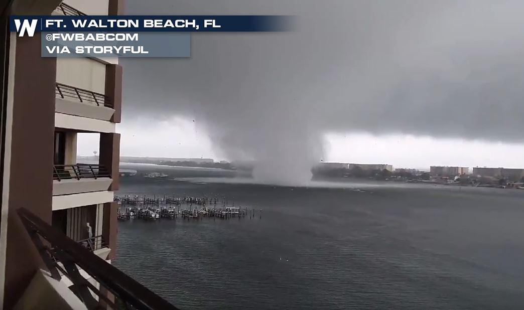
After seeing the dramatic footage Sunday of what was said to be a waterspout making its way onto land to become a tornado in Fort Walton Beach, Florida, there are questions as to whether the term 'waterspout' should have been used.
https://www.facebook.com/WeatherNation/videos/10156446853744874/
This video shows the tornadic storm making its way from the water onto land in the Florida Panhandle.
https://www.facebook.com/WeatherNation/videos/10156446673939874/
Many angles of the storm were recorded, but WeatherNation talked to the National Weather Service (NWS) Office in Mobile about using the term waterspout to describe the storm.
"This was not a waterspout," NWS Meteorologist Jeff Medlin said. "A lot of people get caught up in confusing this with your day in and day out summertime waterspout which have much weaker wind speeds."
https://www.facebook.com/WeatherNation/videos/10156448572504874/
"This was a definite tornado over water," Medlin said. "This is something that we have really worked hard to train the people who are out in boats in our area. They know the difference and we will occasionally use that verbiage 'tornado over water' to elicit the response."
Medlin went on to say that they have confirmed winds with this storm up to 105 miles per hour. And while the damage survey team is still out, there has been preliminary EF-1 damage found.
https://twitter.com/NWSMobile/status/988485186206748672
More information on the storm is expected to be released Monday evening.
Listen to the full interview with Jeff Medlin here:
https://youtu.be/2_m0Lm-_zN0
For WeatherNation - Meteorologist Heather Brinkmann
All Weather News
More
Heavy Rain Returns to Texas This Weekend
It's been a week since the devastating floods
12 Jul 2025 3:10 AM

Medium Range Tropics Forecast Favors Gulf, CSU Updates Seasonal Forecast
While the Atlantic appears quiet, conditions
12 Jul 2025 3:05 AM

Elevated Tornado Risk Targets the Midwest Friday
Friday was another busy day with severe weath
12 Jul 2025 3:00 AM

Storms Return From the Front Range to Texas
Moisture is moving back into the Central and
12 Jul 2025 2:50 AM

Timeline: How Catastrophic Flooding Unfolded in Texas Hill Country
TEXAS - Catastrophic flooding devastated port
11 Jul 2025 10:00 AM

Severe Thunderstorms Expected Across the East Coast
The severe weather and flood threat continues
11 Jul 2025 2:35 AM

Ruidoso Flash Flooding - Record Crest for the Rio Ruidoso River
A slow-moving monsoonal thunderstorm develope
10 Jul 2025 1:55 AM