A Summertime Winter Storm Over the Rockies
Special Stories
10 Sep 2020 8:15 AM
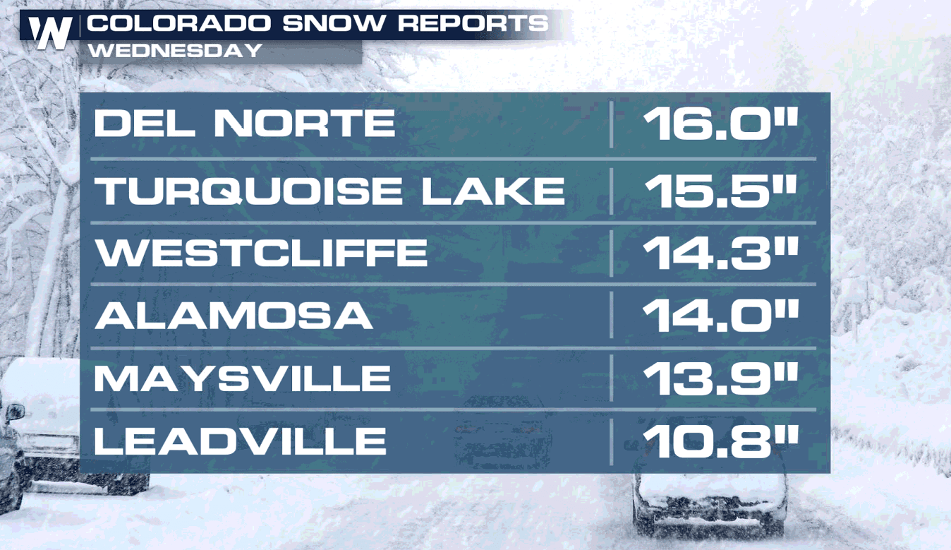
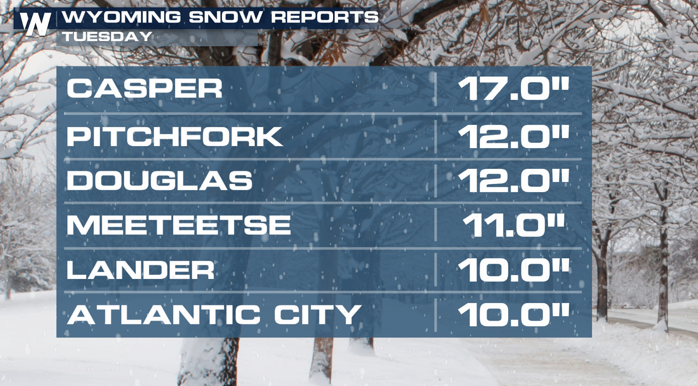
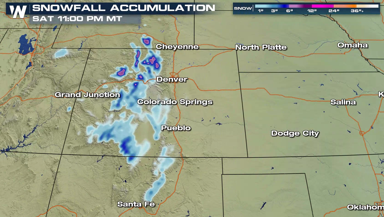
Even though the calendar might say it's still summer, a first round of winter weather has been dropping through the Rockies. Some areas have seen more than a foot of snow, especially in the mountains and higher elevations.
 https://twitter.com/i/status/1303513457967468547
https://twitter.com/i/status/1303687100789714945
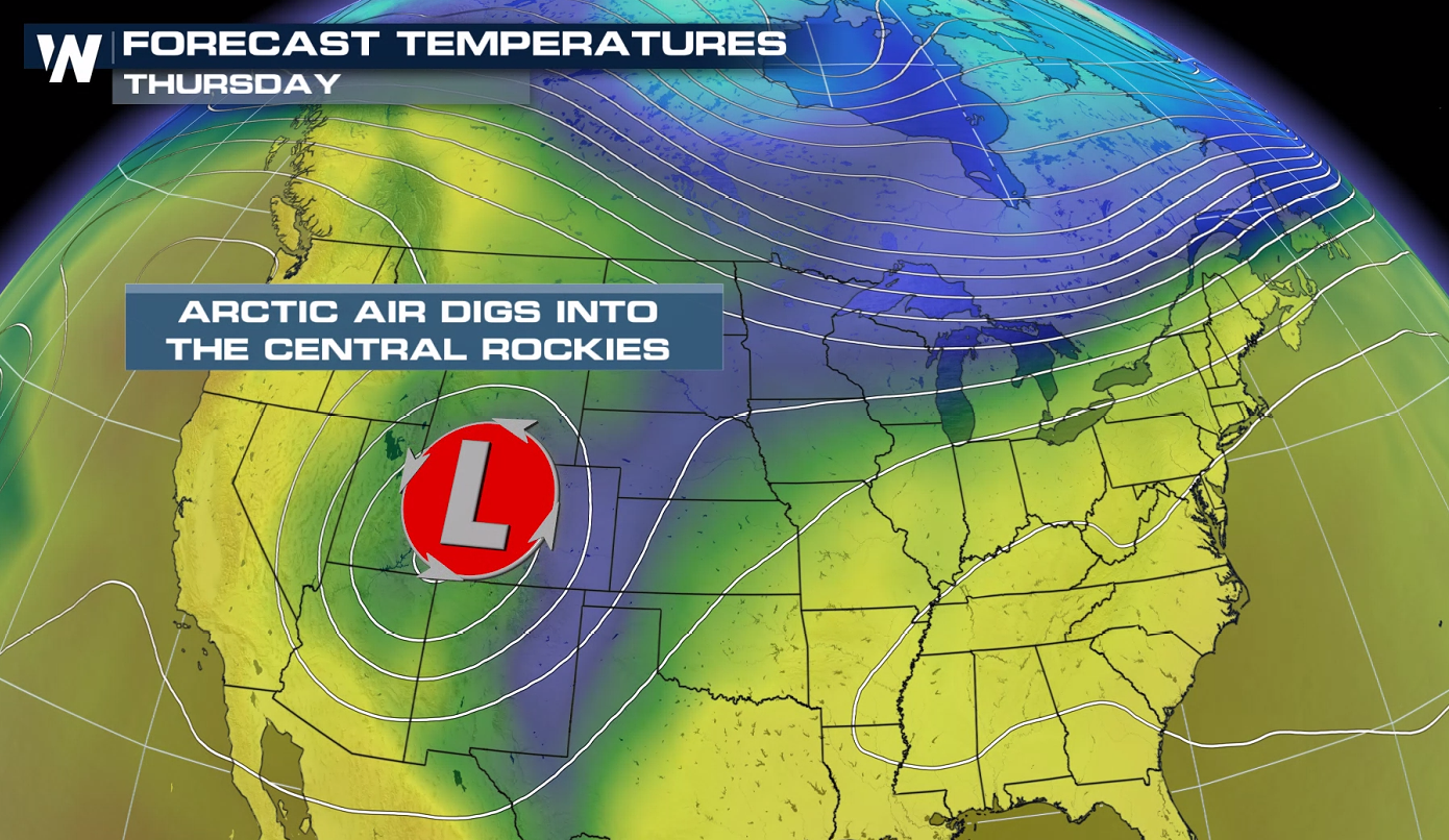
A strong jet stream has pushed over the region, bringing a very cold arctic storm into the Rockies.
https://twitter.com/i/status/1303513457967468547
https://twitter.com/i/status/1303687100789714945
A strong jet stream has pushed over the region, bringing a very cold arctic storm into the Rockies.
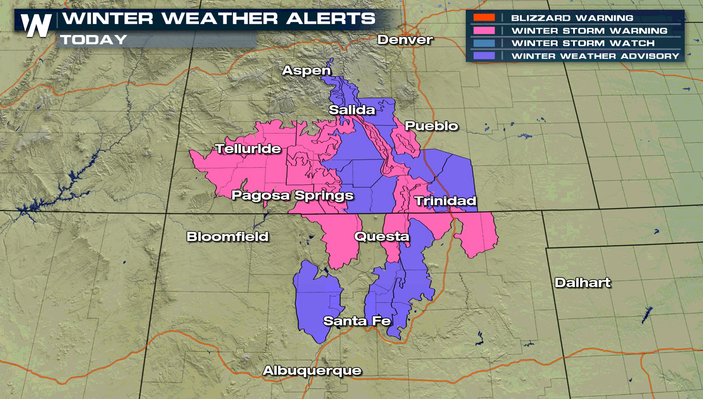
 Winter weather advisories and winter storm warnings are in still in effect from Colorado to New Mexico.
 Significantly colder air will kill unprotected plants and crops. This may also put a big dent in the fall foliage season, killing any living leaves. Additional snowfall will be possible, mainly in the higher elevations, even several inches in some areas!
https://twitter.com/i/status/1303619153941716992
Significantly colder air will kill unprotected plants and crops. This may also put a big dent in the fall foliage season, killing any living leaves. Additional snowfall will be possible, mainly in the higher elevations, even several inches in some areas!
https://twitter.com/i/status/1303619153941716992
 https://twitter.com/i/status/1303558753485074433
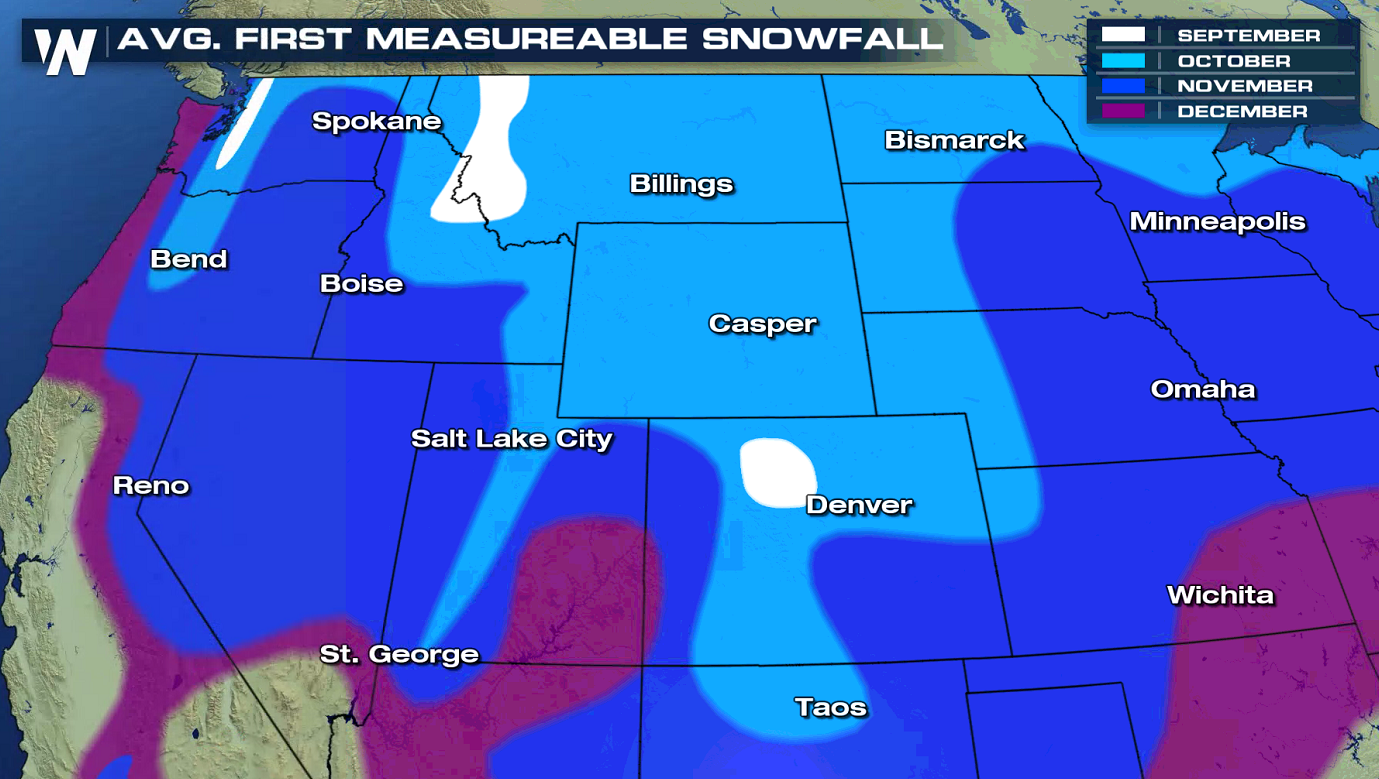
The additional snowfall will be mainly confined to trees, grassy surfaces, elevated surfaces, and the mountainous locations. Up to an additional foot of snow may fall in the highest elevations. No surprise, this is all happening well before the first average snowfall.
https://twitter.com/i/status/1303558753485074433
The additional snowfall will be mainly confined to trees, grassy surfaces, elevated surfaces, and the mountainous locations. Up to an additional foot of snow may fall in the highest elevations. No surprise, this is all happening well before the first average snowfall.
 Please stay with us here at WeatherNation as we bring you more details regarding the storm.
https://twitter.com/i/status/1303513457967468547
https://twitter.com/i/status/1303687100789714945
A strong jet stream has pushed over the region, bringing a very cold arctic storm into the Rockies.
Winter weather advisories and winter storm warnings are in still in effect from Colorado to New Mexico.
Significantly colder air will kill unprotected plants and crops. This may also put a big dent in the fall foliage season, killing any living leaves. Additional snowfall will be possible, mainly in the higher elevations, even several inches in some areas!
https://twitter.com/i/status/1303619153941716992
https://twitter.com/i/status/1303558753485074433
The additional snowfall will be mainly confined to trees, grassy surfaces, elevated surfaces, and the mountainous locations. Up to an additional foot of snow may fall in the highest elevations. No surprise, this is all happening well before the first average snowfall.
Please stay with us here at WeatherNation as we bring you more details regarding the storm.All Weather News
More
Storms Return From the Front Range to Texas
Moisture is moving back into the Central and
10 Jul 2025 10:45 PM

Medium Range Tropics Forecast Favors Gulf, CSU Updates Seasonal Forecast
While the Atlantic appears quiet, conditions
10 Jul 2025 10:40 PM

Severe Thunderstorms Expected Across the East Coast
The severe weather and flood threat continues
10 Jul 2025 10:30 PM

Rounds of Severe Storms to Impact Great Plains and Midwest Through the Weekend
A dynamic summer weather pattern is setting t
10 Jul 2025 10:25 PM

Timeline: How Catastrophic Flooding Unfolded in Texas Hill Country
TEXAS - Catastrophic flooding devastated port
10 Jul 2025 10:00 AM

Ruidoso Flash Flooding - Record Crest for the Rio Ruidoso River
A slow-moving monsoonal thunderstorm develope
10 Jul 2025 1:55 AM
