Wet Weekend Ahead in Florida

Special Stories
25 Jan 2019 8:20 PM
The wettest state in the Lower 48 this weekend will definitely be Florida. Unfortunately the timing could be much better as a few inches of rainfall is forecast to fall during Saturday, Sunday and some of Monday.
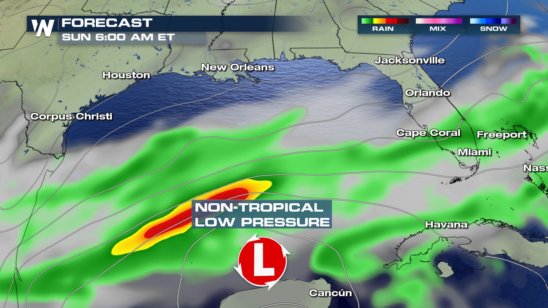 The surface weather forecast on Sunday morning, January 27 where green shows rain and yellows/reds show heavy rain.
On Saturday, light to moderate rain showers will move across parts of South Florida including the Lake Okeechobee region, the Palm Beaches, the Everglades and the Florida Keys. These showers on Saturday will be on the lighter side compared to Sunday. Perhaps you can focus your outdoor weekend plans on Saturday while the weather will cooperate a little more. However by Sunday, that weather story changes completely.
The surface weather forecast on Sunday morning, January 27 where green shows rain and yellows/reds show heavy rain.
On Saturday, light to moderate rain showers will move across parts of South Florida including the Lake Okeechobee region, the Palm Beaches, the Everglades and the Florida Keys. These showers on Saturday will be on the lighter side compared to Sunday. Perhaps you can focus your outdoor weekend plans on Saturday while the weather will cooperate a little more. However by Sunday, that weather story changes completely.
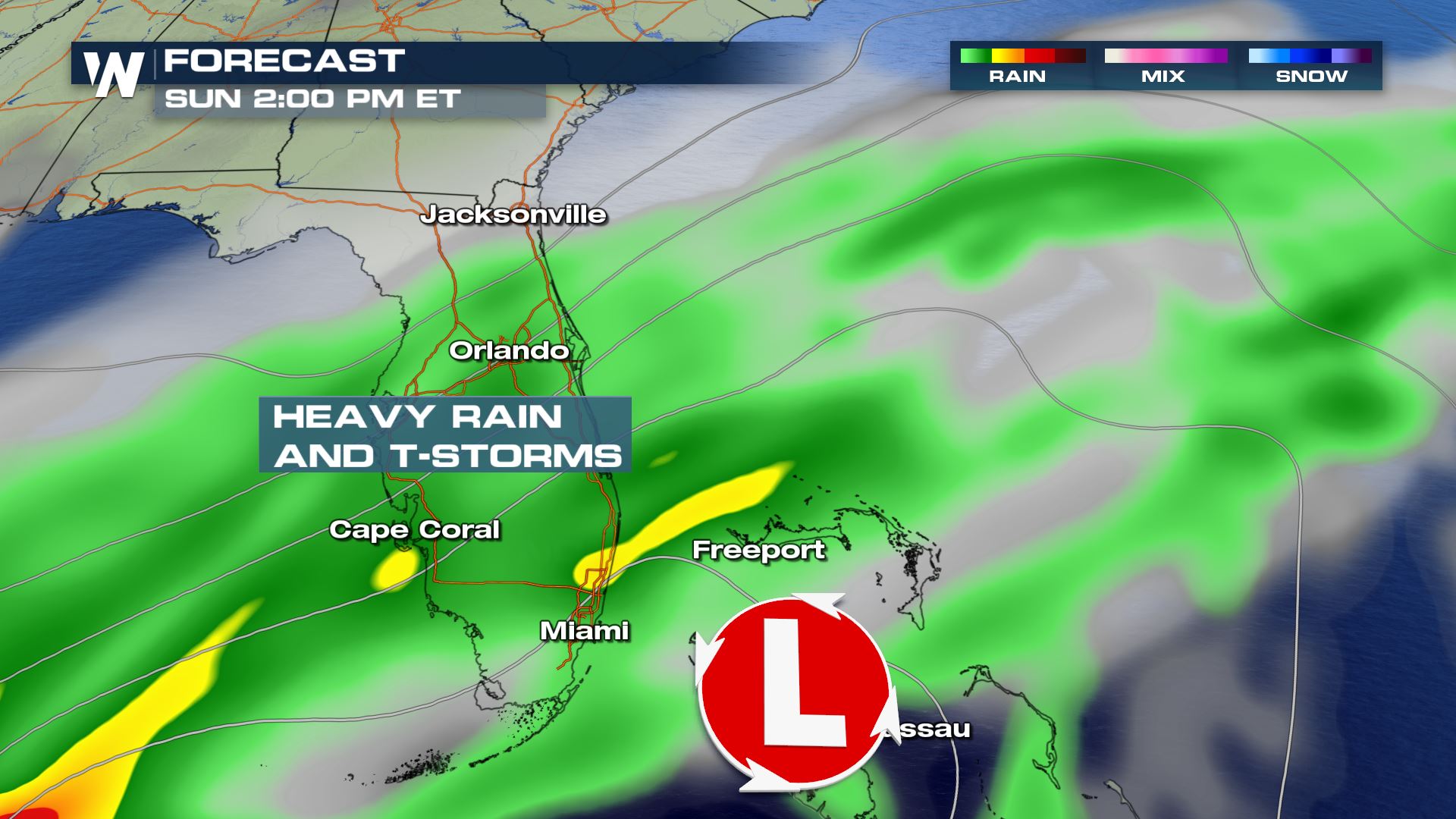 The surface weather forecast on Sunday afternoon, January 27 where green shows rain and yellows show heavy rain.
By Sunday the rain will get much heavier, in fact spread north through *more* of Florida compared to Saturday. That means cities like Tampa, Orlando and St. Augustine will get in on the rainy weather Sunday. While the low pressure system is not expected to be a true, tropical entity it will bring in heavy showers and a few thunderstorms.
The surface weather forecast on Sunday afternoon, January 27 where green shows rain and yellows show heavy rain.
By Sunday the rain will get much heavier, in fact spread north through *more* of Florida compared to Saturday. That means cities like Tampa, Orlando and St. Augustine will get in on the rainy weather Sunday. While the low pressure system is not expected to be a true, tropical entity it will bring in heavy showers and a few thunderstorms.
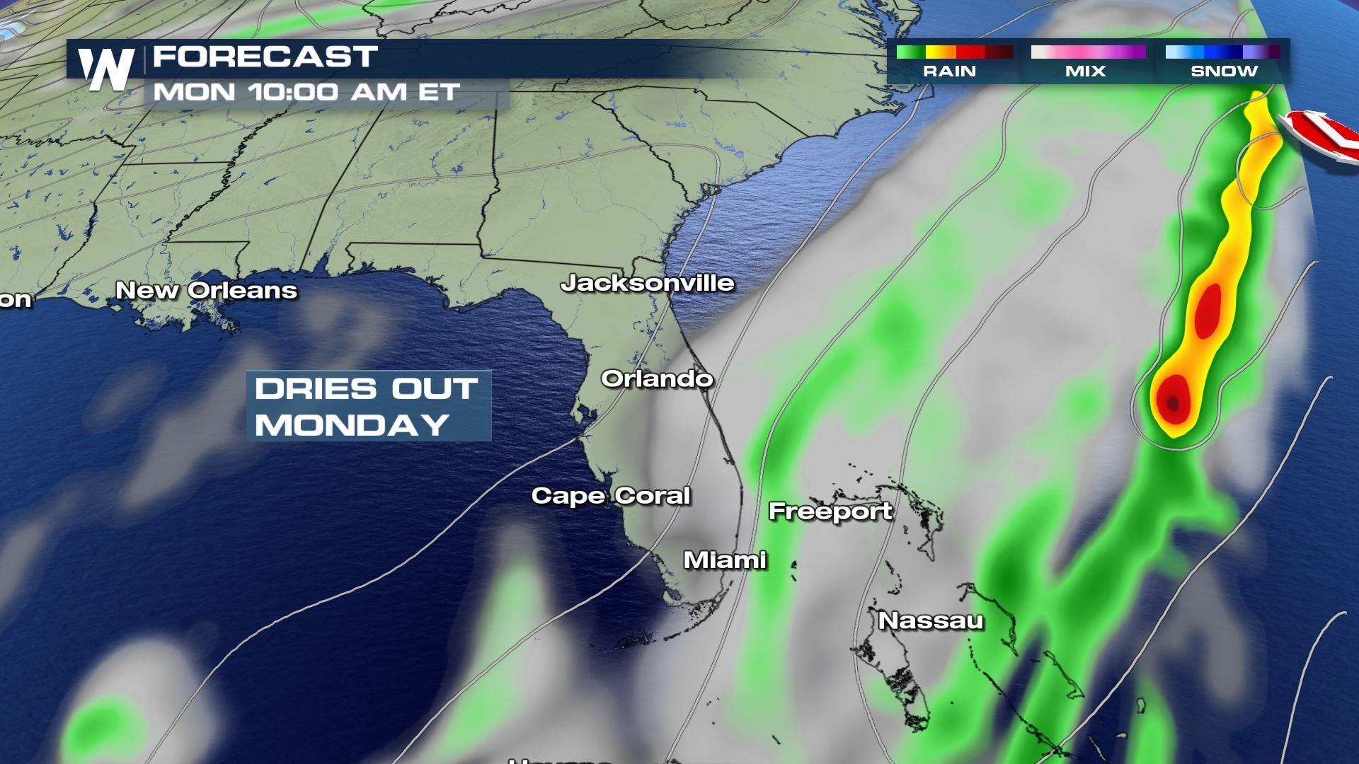 The surface weather forecast on Monday morning, January 28 where green shows rain.
In total as much as 3-5 inches of rain could fall! The highest amounts appear likely across South Florida from the Treasure Coast and Lake Okeechobee, southward.
The surface weather forecast on Monday morning, January 28 where green shows rain.
In total as much as 3-5 inches of rain could fall! The highest amounts appear likely across South Florida from the Treasure Coast and Lake Okeechobee, southward.
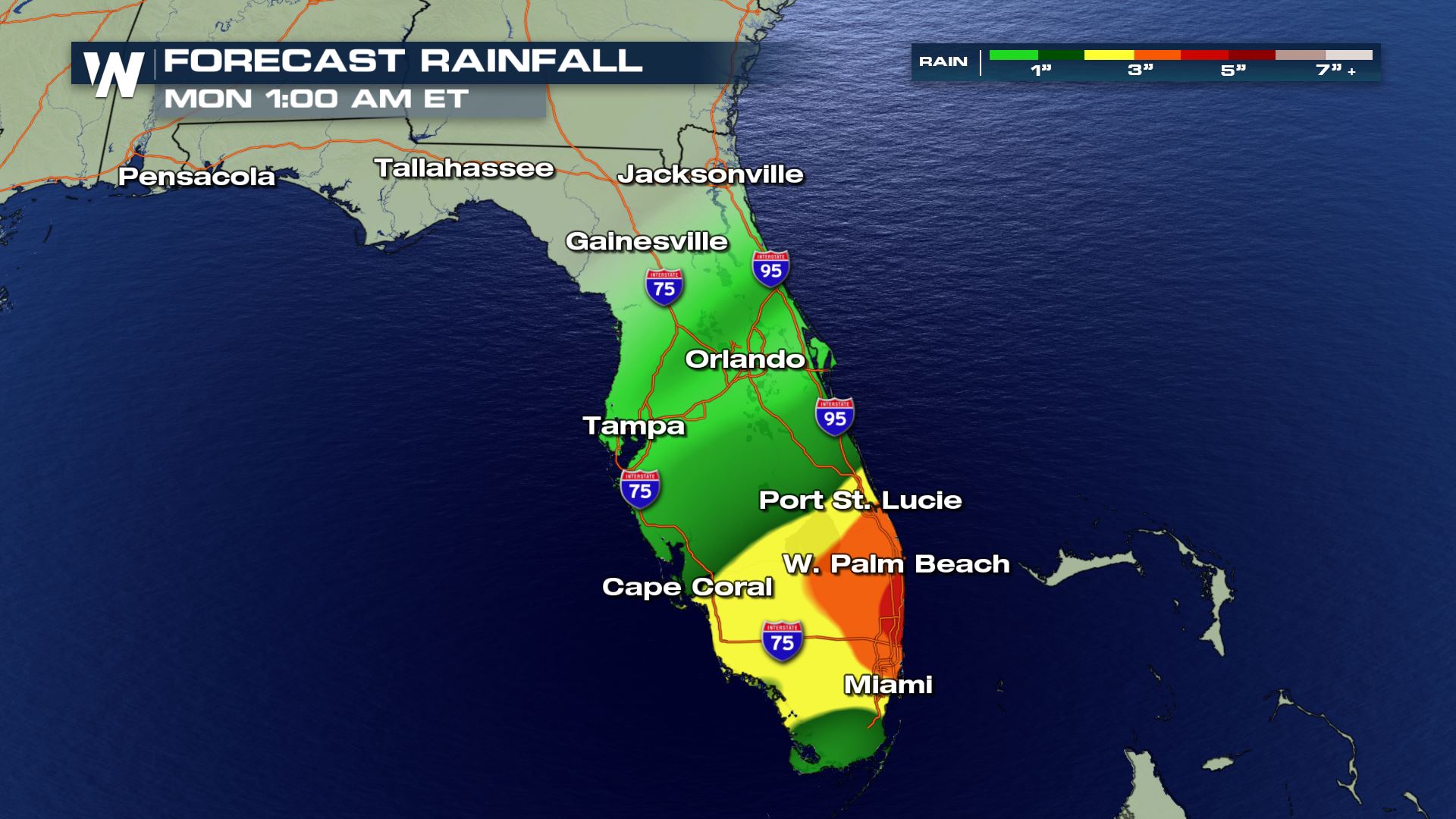 Forecast rainfall through Monday, January 28 where green indicates 0-2", yellow 2-3" and orange 3-4"
This is the dry season for South Florida, meaning what we normally deal with nice, sunny conditions with temperatures in the 70's. This rain will keep things overcast and gray while temperatures will be held in the 50's and 60's for highs on Sunday!
For WeatherNation, Meteorologist Steve Glazier
Forecast rainfall through Monday, January 28 where green indicates 0-2", yellow 2-3" and orange 3-4"
This is the dry season for South Florida, meaning what we normally deal with nice, sunny conditions with temperatures in the 70's. This rain will keep things overcast and gray while temperatures will be held in the 50's and 60's for highs on Sunday!
For WeatherNation, Meteorologist Steve Glazier
The surface weather forecast on Sunday morning, January 27 where green shows rain and yellows/reds show heavy rain.
On Saturday, light to moderate rain showers will move across parts of South Florida including the Lake Okeechobee region, the Palm Beaches, the Everglades and the Florida Keys. These showers on Saturday will be on the lighter side compared to Sunday. Perhaps you can focus your outdoor weekend plans on Saturday while the weather will cooperate a little more. However by Sunday, that weather story changes completely.
The surface weather forecast on Sunday afternoon, January 27 where green shows rain and yellows show heavy rain.
By Sunday the rain will get much heavier, in fact spread north through *more* of Florida compared to Saturday. That means cities like Tampa, Orlando and St. Augustine will get in on the rainy weather Sunday. While the low pressure system is not expected to be a true, tropical entity it will bring in heavy showers and a few thunderstorms.
The surface weather forecast on Monday morning, January 28 where green shows rain.
In total as much as 3-5 inches of rain could fall! The highest amounts appear likely across South Florida from the Treasure Coast and Lake Okeechobee, southward.
Forecast rainfall through Monday, January 28 where green indicates 0-2", yellow 2-3" and orange 3-4"
This is the dry season for South Florida, meaning what we normally deal with nice, sunny conditions with temperatures in the 70's. This rain will keep things overcast and gray while temperatures will be held in the 50's and 60's for highs on Sunday!
For WeatherNation, Meteorologist Steve GlazierAll Weather News
More
Tropics: Fausto Heads to Hawaii; Genevieve Has Formed and Could Become a Major Hurricane
Atlantic BasinBertha has dissipated after mov
25 Jul 2026 11:00 AM

Severe Storms Target the Midwest This Weekend
Extreme heat will be a big story this week ac
25 Jul 2026 11:00 AM

Southeast Flood Risk Lingers Near Stalled Front
A stalled boundary over the Southeast will ke
25 Jul 2026 10:55 AM

Fire Weather Continues This Weekend
Conditions have been really dry out west. We'
25 Jul 2026 10:50 AM

Weekend Heat For the Western and Central United States
Are you over the summer heat yet? Well, more
25 Jul 2026 1:40 AM

Another Round of Storms Targets the Northeast
Tuesday brought severe weather again across p
23 Jul 2026 1:15 AM

Another Round of Severe Weather for the Upper Midwest and Great Lakes
The upper-level low train continues to keep t
21 Jul 2026 1:45 AM