A Closer Look at the Louisiana & Texas Flash Flooding from Last Week
Special Stories
25 May 2021 1:40 AM
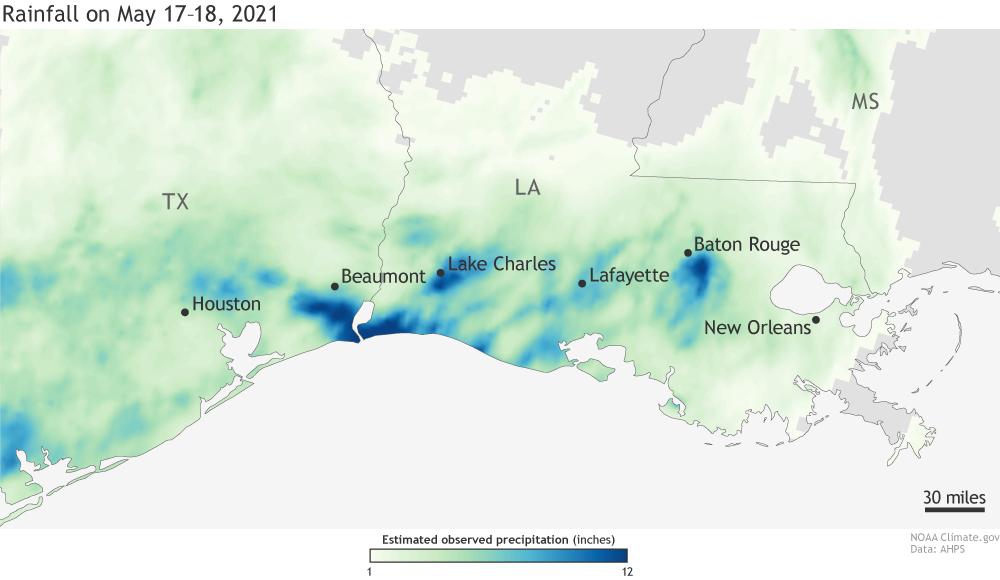
[Cumulative precipitation over May 17-18, 2021 across Texas and Louisiana. Several areas received more than a foot of rain. Map by NOAA Climate.gov, based on AHPS data from the National Weather Service.]
[From NOAA written by Tom Di Liberto] Deadly flash floods ravaged parts of southern Louisiana after torrential rains fell across a water-logged region still recovering from the impacts of two hurricanes during 2020 Atlantic Hurricane season. In particular, Lake Charles, LA, southwest of Baton Rouge, was hard hit, as a foot of rain fell in only 24 hours.
https://twitter.com/WeatherNation/status/1394971012278722564
A slow-moving cluster of thunderstorms allowed torrential rain to fall for hours on May 17 in southwestern Louisiana and neighboring Texas. The result was precipitation totals measured in feet. Lake Charles observed 12.49 inches of rain in just one day—six inches of which fell in just two hours—making May 17, 2021, the third-wettest day in the city’s history. And that’s a history that includes multiple landfalls of incredibly wet hurricanes! Meanwhile, just over the border in Texas, Port Arthur/Beaumont, an area very familiar with astonishing rainfall totals—Hurricane Harvey dropped 26 inches of rain in one day back in 2017—observed 9.86 inches of rain, its eighth-wettest day on record. Overall, a huge swath of the region observed at least six inches of rain on May 17.
https://twitter.com/WeatherNation/status/1394850298842128385
Flash floods
There is simply no way for a community to deal with that much water falling all at one time. According to news reports, the resulting flash flooding led to at least one fatality, turned roads into rivers, submerged cars and inundated homes and businesses across southwestern Louisiana. In Lake Charles, over 100 calls for rescues were made as nearly half the roads in the parish were under some water, according to CNN. The governor of Louisiana even declared a state of emergency due to the amount of rain and flooding. This event is just another in a growing list of weather catastrophes to affect this portion of the Gulf Coast. Lake Charles is still recovering from a double whammy of hurricanes—Hurricanes Laura and Delta—that made landfall just six weeks apart last summer. The one-day rainfall total (9.53 inches) from Hurricane Delta in early October were the ninth-wettest on record for the city. That means that two of the top-ten wettest days on record in Lake Charles have happened in the last eight months. https://www.youtube.com/watch?v=ysenYARrTDU&t=2s [Colorized infrared satellite data showing a river of clouds flowing north from the Gulf of Mexico over eastern Texas and western Louisiana from May 18-20, 2021. The darker orange colors indicate taller, colder cloud tops, which is a sign of more severe storm activity. Animation by NOAA Environmental Visualization Lab.]Why was there so much rain?
The culprit was a seemingly endless supply of moisture and a slow-moving cluster of thunderstorms. This shouldn’t surprise you, but the Gulf Coast is a humid place. With a close proximity to the Gulf of Mexico, moisture is never that far away. And recently the atmospheric set-up over the region was just perfect to tap into that for the creation of long-lasting heavy rains. Southerly winds blowing straight from the Gulf of Mexico north through Louisiana provided a constant stream of warm, humid air that fueled round after round of strong thunderstorms that moved slowly to the east. It was as if Mother Nature left the hose on over southern Louisiana. Edited for WeatherNation by Mace MichaelsAll Weather News
More
Storms Leave Texas, Move Through the Southeast
Several rounds of severe storms rocked the Lo
2 May 2026 12:10 PM

Rain or Shine? Your 152nd Kentucky Derby Forecast
Heading to Churchill Downs this Weekend?Derby
2 May 2026 11:50 AM

Cold Fronts Could Bring the Midwest More Severe Weather
Portions of the Midwest just wrapped up their
2 May 2026 11:39 AM

Potentail for Tropical Development Mid-May in the Eastern Pacific
Ready for hurricane season? The Climate Predi
2 May 2026 10:17 AM


Cooler Air Sweeps From the Plains to the Northeast
A trough of low pressure will keep things coo
2 May 2026 2:10 AM

Further Rain and Snow Chances Out West
We have a rather wet pattern ahead for much o
1 May 2026 11:25 PM