Big Southern Storm Brings Big Weather Threats
Special Stories
8 Dec 2018 11:59 AM
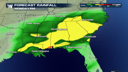
Heavy rain, ice, snow, and severe weather... all part of the latest storm tearing through the southern U.S. Portions of west Texas have already received 10 inches of snow. The mountains of North Carolina could see even more! And the rain has been drenching across almost all of the southeast.
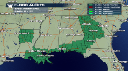
Rainfall totals through Monday will reach 3 inches in many areas. And there could be spots will more than that! All of this rain has prompted the National Weather Service to issue Flash Flood Watches.
 Flash Flood Watches are in effect from Georgia, down to the Gulf Coast, and back into Louisiana. The eastern portion of these watches are in effect through Sunday. The western portion will expire on Saturday.
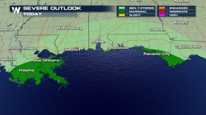
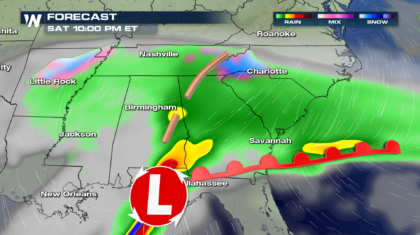
 There will also be a severe weather component with the storm along the gulf coast on Saturday. There could possibly be severe thunderstorms in southern Louisiana, and along the coastline of the Florida panhandle. Some storms could produce straight line winds over 58 mph. There will also be a slight risk for a few tornadoes.
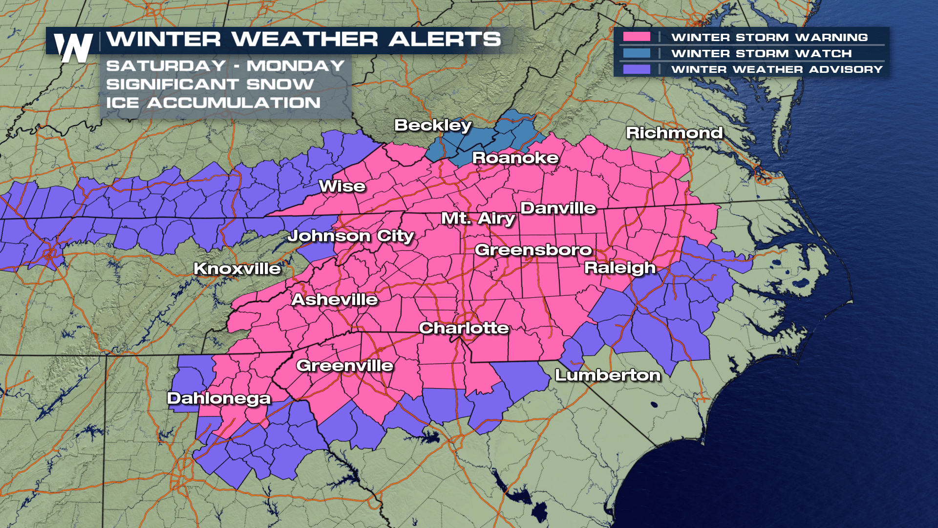
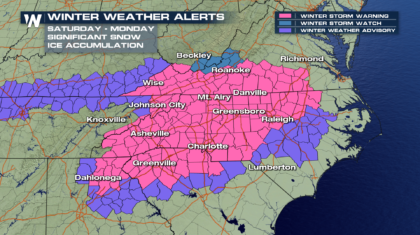
 But where the temperatures will be cold enough, ice and snow will be more of an issue than the rain. Winter Weather Alerts are in effect from southern Virginia and eastern Tennessee, across much of North Carolina, and into Georgia and South Carolina. This is going to be a big winter storm for many!
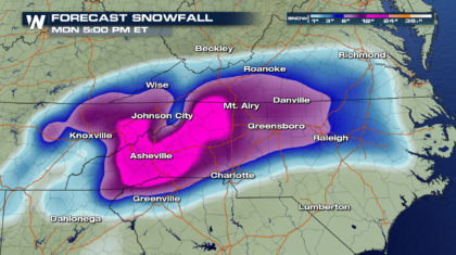
 Check out the potential snow totals. Asheville could easily pick up 12 inches of snow. Charlotte is expecting 4 to 8 inches of snow.
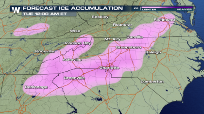
 Much of the region will see rain, before everything turns over to snow. As this transition happens, there may be a period of icing. This could lead to very dangerous road conditions. A layer of ice could form, with snow falling on top of it, covering the hazardous conditions beneath the snow. This could also lead to slip and falls on stoops, parking lots, sidewalks, and driveways. Please use caution when walking or driving.
 Most locations, except for high elevation areas, will see rain much of Saturday. But by Saturday night, everything will start turning over to either snow, ice, or a winter mix. This will begin in western North Carolina.
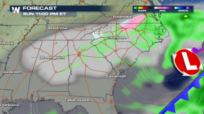
 By Sunday morning, the snow will be flying all across the Appalachian Mountains, into eastern North Carolina, western Tennessee, and down into South Carolina and Georgia.
 The winter weather event will rage on throughout Sunday, before slowly winding down Sunday night. There could be some residual precipitation on Monday, but most of the snow and ice will be done. Road conditions however, may continue to be very poor Monday, and more than likely, on Tuesday as well.
 WeatherNation will be tracking this storm right through the weekend. You can get the very latest information by watching on the Dish Network, Roku, Apple TV, and Amazon Fire TV.
For WeatherNation: Meteorologist Matt Monroe
WeatherNation will be tracking this storm right through the weekend. You can get the very latest information by watching on the Dish Network, Roku, Apple TV, and Amazon Fire TV.
For WeatherNation: Meteorologist Matt Monroe
Flash Flood Watches are in effect from Georgia, down to the Gulf Coast, and back into Louisiana. The eastern portion of these watches are in effect through Sunday. The western portion will expire on Saturday.
There will also be a severe weather component with the storm along the gulf coast on Saturday. There could possibly be severe thunderstorms in southern Louisiana, and along the coastline of the Florida panhandle. Some storms could produce straight line winds over 58 mph. There will also be a slight risk for a few tornadoes.
But where the temperatures will be cold enough, ice and snow will be more of an issue than the rain. Winter Weather Alerts are in effect from southern Virginia and eastern Tennessee, across much of North Carolina, and into Georgia and South Carolina. This is going to be a big winter storm for many!
Check out the potential snow totals. Asheville could easily pick up 12 inches of snow. Charlotte is expecting 4 to 8 inches of snow.
Much of the region will see rain, before everything turns over to snow. As this transition happens, there may be a period of icing. This could lead to very dangerous road conditions. A layer of ice could form, with snow falling on top of it, covering the hazardous conditions beneath the snow. This could also lead to slip and falls on stoops, parking lots, sidewalks, and driveways. Please use caution when walking or driving.
Most locations, except for high elevation areas, will see rain much of Saturday. But by Saturday night, everything will start turning over to either snow, ice, or a winter mix. This will begin in western North Carolina.
By Sunday morning, the snow will be flying all across the Appalachian Mountains, into eastern North Carolina, western Tennessee, and down into South Carolina and Georgia.
The winter weather event will rage on throughout Sunday, before slowly winding down Sunday night. There could be some residual precipitation on Monday, but most of the snow and ice will be done. Road conditions however, may continue to be very poor Monday, and more than likely, on Tuesday as well.
WeatherNation will be tracking this storm right through the weekend. You can get the very latest information by watching on the Dish Network, Roku, Apple TV, and Amazon Fire TV.
For WeatherNation: Meteorologist Matt Monroe
All Weather News
More

After Reaching Category 5, Genevieve Weakens in the Pacific
PacificFausto is now a post-tropical cyclone.
30 Jul 2026 12:00 PM

Flooding Risk Increases as Heavy Rain Targets the Tri-State Area
Tuesday, heavy rainfall moved across the Nort
30 Jul 2026 12:25 AM

Severe Weather: Energy From the Midwest Now in the Southeast
UPPER MIDWEST - Through Monday, dangerous tor
29 Jul 2026 10:30 PM


Southeast Flood Risk Lingers Near Stalled Front
A stalled boundary over the Southeast will ke
25 Jul 2026 10:55 AM

Another Round of Storms Targets the Northeast
Tuesday brought severe weather again across p
23 Jul 2026 1:15 AM