Hurricane Prep Week 2023: Changes Coming to the Forecast in 2023
We are a little under two months away from the start of the Atlantic Hurricane Season on June 1st, and even closer to the Eastern Pacific Hurricane Season on May 15th. The National Hurricane Center (NHC) in Miami, FL is responsible for issuing outlooks, alerts and discussions on areas of interest in the tropics along with storms that develop in both ocean basins. This year, there are some changes to the products that NHC issues, to help more clearly communicate threats and allow appropriate preparation timelines for storms.
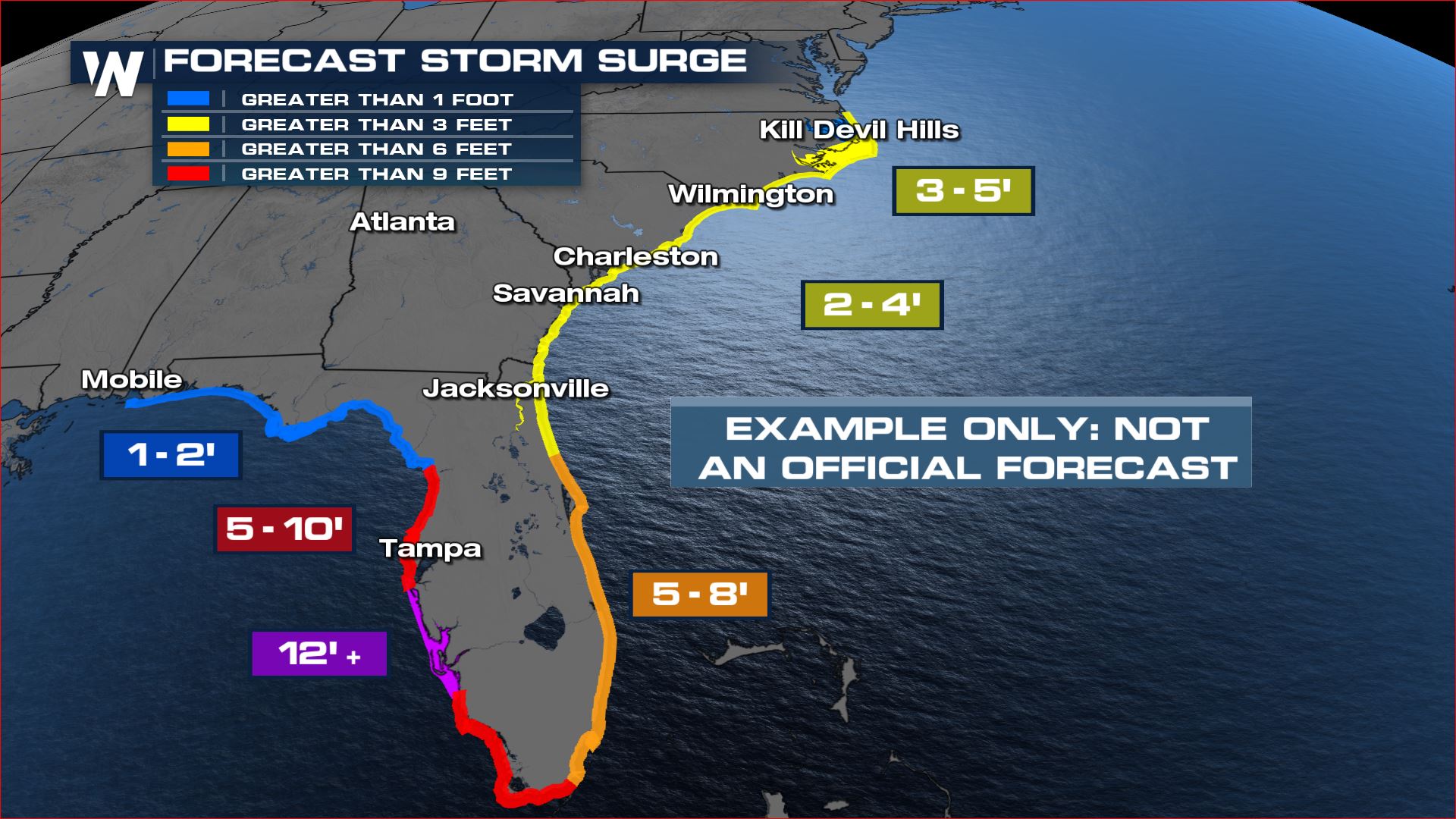
Change 1: Storm Surge
The "Peak Storm Surge" graphics have been experimental in the last few seasons, but as of 2023 they will be fully operational. This will not change how WeatherNation brings you storm surge forecasts, we have implemented the "new" storm surge graphics in our past two seasons. Storm surge outlooks are issued 4x daily, at 5a, 11a, 5p and 11p EDT. Additionally, the potential storm surge flooding map will now be available for the U.S. Virgin Islands and Puerto Rico. According to NHC, these maps "takes into account: Flooding due to storm surge from the ocean, including adjoining tidal rivers, sounds, and bays, Normal astronomical tides, Land elevation, Uncertainties in the track, landfall location, intensity, forward speed, and size of the cyclone".
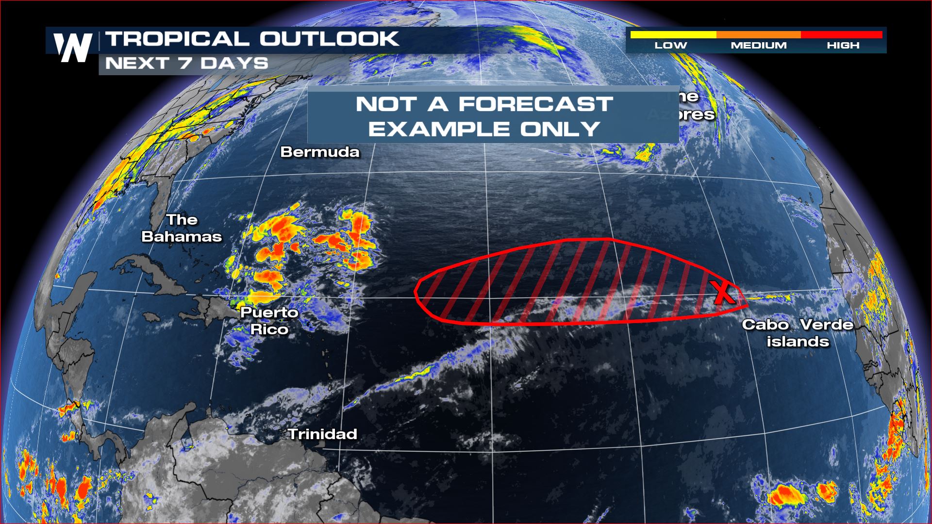
Change 2: Tropical Development Outlooks & Invests
Tropical storm outlooks have previously been issued for 2 and 5 day periods by the National Hurricane Center. They highlight areas of Low, Medium and High probability of development using "x"s and hatched regions in yellow, orange and red. In the 2023 season NHC will still issue 2 day outlooks but instead of 5 days will transition to 7 day outlooks. The additional lead time will be helpful for people to prepare ahead of a potential storm. Additionally, if a storm is labeled "Invest" as in an area that the NHC will be watching for potential development, those statistics and observations will be available on NHC's homepage. The National Hurricane Center begins issuing Tropical Cyclone Outlooks in both the Atlantic and Eastern Pacific on May 15, or sooner if required.
Change 3: Reducing Redundancy in Communication
Previously, tropical watches & warnings were published in multiple text advisories from the NHC and lead to communication failures and the potential for errors. This year, "NHC will remove land-based tropical cyclone watches and warnings from the Tropical Cyclone Forecast/Advisory (TCM). Currently, a list of tropical cyclone watches and warnings are provided in both the TCM text product and the Tropical Cyclone Public Advisory (TCP) issued by NHC." This means watches/warnings will ONLY be seen in the Tropical Cyclone Public Advisory or TCPs.
Change 4: Tropical Cyclone Error Track
Each year NHC uses analysis to determine how accurate their forecasts were from the actual path of the storm's center and work to correct the uncertainty. The "cone of uncertainty" is the official forecast of the storm's center (the line) and then the potential margin of error in the forecast based on historical accuracy. The forecast "cone" accounts ONLY for the center of the storm, and not for the potential impacts away from the center of the storm. This year there are no major changes to the Atlantic Basin forecast cone, but for the E. Pacific "it will be similar in size to the 2022 cone through 60 h, and slightly smaller at days 3 through 5."
Stay with WeatherNation for the latest in the Hurricane Season - our Hurricane Prepardness Week begins May 15.


