Wintry Weather Returns to New England
Special Stories
23 Oct 2018 5:08 PM
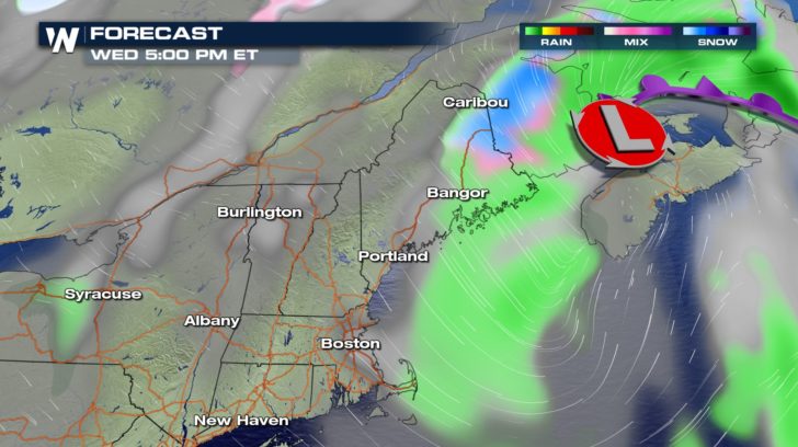
A quick-moving storm system that brought tornado warnings to southern New England Tuesday will coat northern New England in a blanket of fresh snow into Wednesday. In fact, the higher elevations of New Hampshire endured heavy snow and high wind as early as Tuesday afternoon.
https://twitter.com/MWObs/status/1054847256728346624
Northern New Hampshire and non-coastal Maine will receive the highest snowfall amounts from winter's glancing blow. It should come as no surprise since temperatures are certainly cold enough.
https://twitter.com/NWSCaribou/status/1054732074555531266
Temperatures are expected to remain in the 30s for afternoon highs on Wednesday. Winter Weather Advisories and Winter Storm Warnings are posted for several counties in northern New England where heavy, wet snow is forecast.
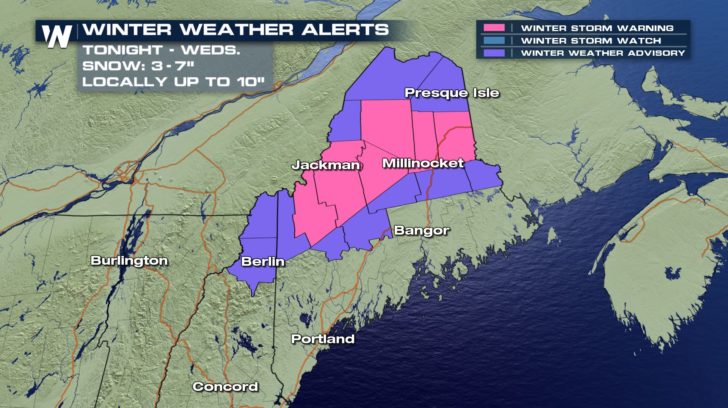 From late Tuesday night through Wednesday, snow will pile up between 3 and 7 inches. A few locations could potentially pick up 10 inches of snow.
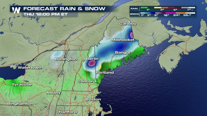 Heavy bursts of snowfall may reduce visibility for the morning drive to work, with snow lingering in some areas for the afternoon drive home.
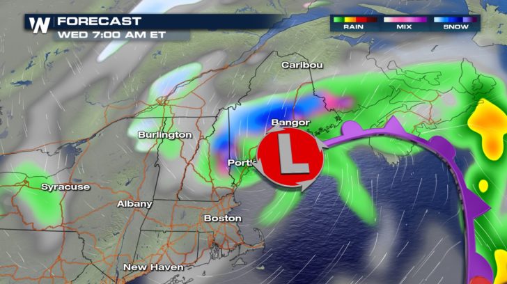
 Looking ahead, the potential for the season's first Nor'easter is on the horizon by the weekend. A low pressure in the Gulf of Mexico bringing rain to states like Texas will move east through Florida by Friday. This low will track up the East Coast during the weekend and bring heavy rain, gusty wind, high surf, and the potential for beach erosion.
https://twitter.com/NWSEastern/status/1054852199145185280
While temperatures will remain above freezing for many, some of the higher mountains in the interior Northeast may pick up some snow. Be sure to follow WeatherNation as we track this potential Nor'easter.
- Meteorologist Joe Astolfi
Looking ahead, the potential for the season's first Nor'easter is on the horizon by the weekend. A low pressure in the Gulf of Mexico bringing rain to states like Texas will move east through Florida by Friday. This low will track up the East Coast during the weekend and bring heavy rain, gusty wind, high surf, and the potential for beach erosion.
https://twitter.com/NWSEastern/status/1054852199145185280
While temperatures will remain above freezing for many, some of the higher mountains in the interior Northeast may pick up some snow. Be sure to follow WeatherNation as we track this potential Nor'easter.
- Meteorologist Joe Astolfi
From late Tuesday night through Wednesday, snow will pile up between 3 and 7 inches. A few locations could potentially pick up 10 inches of snow.
Heavy bursts of snowfall may reduce visibility for the morning drive to work, with snow lingering in some areas for the afternoon drive home.
Looking ahead, the potential for the season's first Nor'easter is on the horizon by the weekend. A low pressure in the Gulf of Mexico bringing rain to states like Texas will move east through Florida by Friday. This low will track up the East Coast during the weekend and bring heavy rain, gusty wind, high surf, and the potential for beach erosion.
https://twitter.com/NWSEastern/status/1054852199145185280
While temperatures will remain above freezing for many, some of the higher mountains in the interior Northeast may pick up some snow. Be sure to follow WeatherNation as we track this potential Nor'easter.
- Meteorologist Joe AstolfiAll Weather News
More
Another Day of Storms in New Mexico
A powerful low pressure system has been movin
24 Oct 2026 10:30 AM

Hurricane Vance Swirling in the Pacific
After becoming a hurricane Friday, Vance quic
24 Oct 2026 10:25 AM

Warmer Than Average: Above-Normal Temperatures Across the Central U.S. This Week
WHAT TO EXPECTA ridge of high pressure linger
24 Oct 2026 10:00 AM


Several Fires Break Out in SoCal Last Week Amid Santa Ana Wind Event
Santa Ana winds helped several fires grow qui
19 Oct 2026 1:25 PM

Another Cold Morning Before Things Warm Back Up
Across portions of the Ohio Valley through th
19 Oct 2026 10:15 AM

Severe Risk Diminishing Saturday Morning for the Northeast
Severe Storm PotentialSevere risk is decreasi
16 Oct 2026 10:20 AM